| Wednesday | Wednesday Night | Thursday | |
|---|---|---|---|
| Cloud Cover: | Mostly Cloudy | Partly Cloudy | Mostly Clear |
| Temperatures: | 30 to 37 deg. F. | 9 to 13 deg. F. | 19 to 25 deg. F. |
| Wind Direction: | Southwest | West | West |
| Wind Speed: | 39G66 | 23G53 | 12G23 |
| Snowfall: | 4" to 6" in. | 0" in. | 0" in. |
| Snow Line: | 3500' | 1000' | 0' |
Whitefish Range
Swan Range
Flathead Range and Glacier National Park
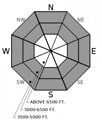
How to read the forecast
An Avalanche Warning is in effect until midnight tonight. Very dangerous avalanche conditions have developed overnight and large natural avalanches are expected today. You may be able to trigger very large avalanches from a distance. Loading from intense snowfall will last throughout the morning and strong winds will continue to build drifts through tonight. Avoid traveling on and under slopes steeper than about 30 degrees. Very large avalanches can come from above and run into the lower elevations.

4. High
?
Above 6500 ft.
4. High
?
5000-6500 ft.
3. Considerable
?
3500-5000 ft.
- 1. Low
- 2. Moderate
- 3. Considerable
- 4. High
- 5. Extreme
-
Type ?
-
Aspect/Elevation ?

-
Likelihood ?CertainVery LikelyLikelyPossible
 Unlikely
 -
Size ?HistoricVery LargeLargeSmall

Slabs of new and drifted snow can be 1 to 3 feet thick after intense loading over the past 24 hours. Heavy snowfall and strong winds will continue today. On slopes steeper than about 30 degrees, natural and human-triggered avalanches large enough to bury and kill you are very likely. Avoid traveling in, and under, avalanche terrain.
-
Type ?
-
Aspect/Elevation ?

-
Likelihood ?CertainVery LikelyLikelyPossible
 Unlikely
 -
Size ?HistoricVery LargeLargeSmall

Weak layers buried 1 to 5 feet deep in the snowpack are being pushed to their limits. Rapid loading from new snow, wind, and rain on snow has increased the likelihood for very large persistent slab avalanches. Deeper layers may be triggered from above or from adjacent terrain. Avalanches failing on deeper weak layers may run down into lower elevations. They pose a serious overhead hazard. It is possible for an avalanche to take out the entire season's snowpack, especially below areas where recent glide cracks have opened up in the Flathead Range and Glacier Park.
-
Type ?
-
Aspect/Elevation ?

-
Likelihood ?CertainVery LikelyLikelyPossible
 Unlikely
 -
Size ?HistoricVery LargeLargeSmall

Freezing levels began to rise yesterday and have steadily marched above 6500’ overnight. That warming, and rain on snow, likely caused a round of natural loose wet avalanches. They will still be a threat this morning until a cold front passes mid-day and brings temperatures and snow levels crashing down by this afternoon. Avoid very steep terrain with wet snow and roller balls. Watch out for steep terrain above you at lower elevations.
Slabs of new and drifted snow up to 18 inches thick were reactive across the region yesterday. We received reports of human triggered slides from across the Whitefish Range and in the Middle Fork during daylight hours. These avalanches were largely failing where the new snow meets the old snow.
Precipitation only increased overnight. As of early this morning, Big Mountain has been slammed with over 2” of snow water equivalent and roughly 15” of snow. The Stahl Peak weather station is reporting 1.3” of new water and 7” of snow. The Flattop Snotel is showing 1.6” of water and 11” of new snow. Noisy Basin has seen 2.2” of water and 10” of snow. Winds have been steady at snow-blowing speeds with strong gusts. Another .4-.5” of water and increasing winds are expected through tonight.
All of this new loading is over-burdening layers of surface hoar and near-surface facets in sheltered areas. The new snow is top-heavy with lower density snow underneath the stiffer snow above. In wind stripped areas, and below about 6500’, the new snow has been bonding poorly to thin crusts. Much of the new precipitation fell as rain at lower elevations. Roller balls tumbled yesterday below 5500' and loose wet avalanches likely ran overnight. Freezing levels have climbed above 6500’ this morning.
Deeper in the snowpack, recently buried surface hoar and faceted crusts have been found 12 to 24 inches below the surface. Crusts and weak facets from mid and early December are common 2 to 5 feet below the surface. These layers are being tested and are unreliable during this kind of heavy loading event. Glide cracks have opened recently in the Flathead Range and the southern tip of Glacier Park. Similar cracks opened, and subsequently failed, around the time of the Solstice storm. That storm bears the closest resemblance to the current situation. Monster avalanches can fail deep within the snowpack, or even on the ground. Check out the recent blog post by veteran forecaster, Mark Dundas, for an excellent summary of the state of our snowpack.
This video illustrates how the danger was rising through yesterday afternoon: Increasing Danger in the Flathead
The snow level this morning is above 6500'. A cold front passes through our area late this morning. Winds will increase significantly thoughout the morning with periods of heavy snowfall. Snow levels will come crashing down by this afternoon. Showers linger into the evening with continued strong winds.
This forecast applies only to backcountry areas outside established ski area boundaries. The forecast describes general avalanche conditions and local variations always occur. This forecast expires at midnight on the posted day unless otherwise noted. The information in this forecast is provided by the USDA Forest Service who is solely responsible for its content.


