THIS AVALANCHE FORECAST EXPIRED ON January 10, 2021 @ 12:07 am
Avalanche Forecast published on January 9, 2021 @ 7:07 am
Issued by Mark Dundas - Flathead National Forest

Whitefish Range

How to read the forecast

Several generations of wind slabs found on wind-loaded slopes are healing slowly, but you should still approach them with caution. Cracking is a sign that you have found an unstable slab. Triggering a slide on a weak layer buried 1-4’ deep remains a concern. After reports of reactive buried surface hoar Friday, we've increased the likelihood that you could trigger a large dangerous avalanche. If you are not interested in digging, choosing planar well-supported terrain is your safest choice. 

2. Moderate

?

Above 6500 ft.
Heightened avalanche conditions on specific terrain features. Evaluate snow and terrain carefully; identify features of concern.

1. Low

?

5000-6500 ft.
Generally safe avalanche conditions. Watch for unstable snow on isolated terrain features.

1. Low

?

3500-5000 ft.
Generally safe avalanche conditions. Watch for unstable snow on isolated terrain features.
    Heightened avalanche conditions on specific terrain features. Evaluate snow and terrain carefully; identify features of concern.
  • 1. Low
  • 2. Moderate
  • 3. Considerable
  • 4. High
  • 5. Extreme
Avalanche Problem 1: Wind Slab
  • Type ?
  • Aspect/Elevation ?
  • Likelihood ?
    Certain
    Very Likely
    Likely
    Possible
    Unlikely
  • Size ?
    Historic
    Very Large
    Large
    Small

Steady light winds, mild temperatures, and dry conditions continue strengthening slabs formed this week. Leeward aspects and cross-loaded slopes hold a potpourri ranging from larger, geriatric beasts created earlier in the week to thin, fresh-faced youngsters that cap the surface. Slabs are stiffening and becoming more difficult to trigger with time, but any triggered slides may be surprisingly large. Stiff, dense snow that your skis or machine ride above indicate that you have found a slab. They may sound hollow, look dune shaped, and have a rippled appearance. Sheltered terrain offers softer, more enjoyable, and safer conditions.

Avalanche Problem 2: Persistent Slab
  • Type ?
  • Aspect/Elevation ?
  • Likelihood ?
    Certain
    Very Likely
    Likely
    Possible
    Unlikely
  • Size ?
    Historic
    Very Large
    Large
    Small

Yesterday, two Flathead Range locations produced concerning stability test results with propagation on a buried layer of surface hoar. In one case, the block popped out into the lap of the observer in multiple sites. Earlier in the week, buried surface hoar was noted in two Swan Range locations and may have been the weak layer in two slab avalanches. Surface hoar has been found in the northern Whitefish Range but not to the extent as the southern part of our advisory area. Several crusts and weak layers have proven problematic and are buried one to four feet below the surface, with this layer being the most recent troublemaker. Cornice falls have the ability to trigger buried layers, and we recommend that you do not dawdle on slopes with these wind-formed features above. Digging into the snowpack is the only way to identify if these layers are present. Stability tests help determine if these layers are reactive, but tests are not foolproof. Terrain selection remains the only constant for dealing with this problem. Planar slopes with a uniformly deep snowpack are safer than undulating slopes with rollovers or a variable snowpack depth found on sunny or windswept aspects.  

Forecast discussion

We first listed Persistent Slab as an avalanche problem on December 19 following several skier triggered slides in the Canyon Creek area of the southern Whitefish Range. Over the past three weeks, a variety of weak layers and crusts have taken center stage; mid-November, December 9 (Mean Mr. Custard), December 22 (Solstice), and most recently, surface hoar. We have a poor grasp on the distribution of surface hoar, and this is what we know so far:

*     Skyland area of the eastern Flathead Range (Saturday) - Observers found a well-preserved layer of surface hoar 40 cm below the surface on an east aspect at 6800’. During stability tests, the entire block popped into their lap with 10-13 taps in multiple locations. Despite a week of windy conditions, the surface hoar had survived because these east-facing aspects went unaffected by the wind. 

*     Marion Lake area of the Flathead Range (Saturday) - Propagation was noted with moderate force on a SE sheltered slope at 6500’. The failure occurred 60 cm down on a well-preserved layer of buried surface hoar.

*     Noisy Basin (Thursday) - Clancy found a 1 cm surface hoar layer buried under about 45 cm. The feathers were broken in wind-exposed areas but better preserved on sheltered, northerly slopes where they could easily pull hand shear blocks from them. 

*     Northern Whitefish Range (Tuesday) - Clancy and Guy found a thin layer of buried surface hoar down about 50 cm. They noted 2 Persistent Slab avalanches that failed on either the surface hoar or the 12/22 interface.

*     Northern Swan around Jenny Lake (Monday) -  Guy and Jenny found a layer of well-preserved buried surface hoar capped by a thin crust. This layer was found on all aspects from 6,000 ft to the ridgeline, and they noted two wind slab avalanches that may have failed on this layer

Hear ye, hear ye! We need to get a handle on the distribution of buried surface hoar layers and are asking for your help. If you regularly dig pits, or don't but want to start the New Year off on the right foot, tell us what you see. The surface hoar we are finding is 15-25” inches, or so, below the surface and sometimes shows up as a thin grey stripe in your pit wall. You will have a better chance of locating this in areas sheltered from the wind. If you don’t have an interest in stability tests, no problem, send us the info on where you find it so that we can track this beast. Submit your information on our web page or call or text an observation to:40666AVYOB. Thank you for your support.

Weather and CURRENT CONDITIONS
weather summary

Cloud cover may limit warming, especially on the valley floor. If you can get above the cloud deck, mild temperatures, sunshine, and light winds await. 

Two-Day Mountain Weather Forecast Produced in partnership with the Missoula NWS
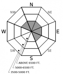
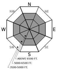
For 5000 ft. to 7000 ft.
Saturday Saturday Night Sunday
Cloud Cover: Mostly Cloudy Mostly Cloudy Mostly Cloudy
Temperatures: 20 to 26 deg. F. 15 to 17 deg. F. 21 to 28 deg. F.
Wind Direction: West Southwest Southwest
Wind Speed: 8 12 14G28
Snowfall: 0" in. 0" in. 0" in.
Snow Line: 2000' 1500' 2000'
Disclaimer

This forecast applies only to backcountry areas outside established ski area boundaries. The forecast describes general avalanche conditions and local variations always occur. This forecast expires at midnight on the posted day unless otherwise noted. The information in this forecast is provided by the USDA Forest Service who is solely responsible for its content.