| Wednesday | Wednesday Night | Thursday | |
|---|---|---|---|
| Cloud Cover: | Mostly Cloudy | Partly Cloudy | Mostly Cloudy |
| Temperatures: | 22 to 28 deg. F. | 17 to 21 deg. F. | 25 to 31 deg. F. |
| Wind Direction: | Southwest | Southwest | Southwest |
| Wind Speed: | 17G31 | 16G29 | 17G30 |
| Snowfall: | 0" to 2" in. | 2" to 6" in. | 1" to 5" in. |
| Snow Line: | 4000' | 4000' | 3500' |
Whitefish Range
Swan Range
Flathead Range and Glacier National Park
How to read the forecast
Several models of wind slab are on offer today. All can be dangerous. Thin, fresh deposits may cover older, stubborn drifts below. The first may be more manageable. The latter can be harder, larger, and break in unexpected ways. Sheltered slopes where the snow is soft are a safer bet. You can manage uncertainty about the distribution of buried weak layers by choosing low-angled, planar slopes without terrain traps below.

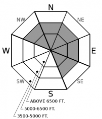
2. Moderate
?
Above 6500 ft.
2. Moderate
?
5000-6500 ft.
1. Low
?
3500-5000 ft.
- 1. Low
- 2. Moderate
- 3. Considerable
- 4. High
- 5. Extreme
-
Type ?
-
Aspect/Elevation ?

-
Likelihood ?CertainVery LikelyLikelyPossible
 Unlikely
 -
Size ?HistoricVery LargeLargeSmall

Waxing and waning winds over the past several days have left layered slabs below ridgelines and on cross-loaded features further down slope. These slabs rest on crusts and even buried surface hoar. A few inches of new snow and moderate winds may add new, thin slabs on the surface. Watch for blowing snow, growing cornices, and rippled, rounded drifts as signs that you are heading into wind-load terrain. Steep, convex, and unsupported slopes are where you’re most likely to trigger a small slab at the surface, or worse, a bigger, hard slab underneath.
-
Type ?
-
Aspect/Elevation ?

-
Likelihood ?CertainVery LikelyLikelyPossible
 Unlikely
 -
Size ?HistoricVery LargeLargeSmall

It’s not going away. Persistent slab avalanches up to 2 ½ feet deep failed naturally as recently as the 3rd. Faceted crusts and surface hoar are buried throughout the middle and upper snowpack. These layers are likely culprits of most of the human and natural triggered avalanches over the past two weeks. The problem is spotty and the picture is fuzzy. Your best option is to use terrain to your advantage. Steer away from rocky, complex start zones, and be wary of convexities further downslope. This is the kind of terrain, where the snowpack is thin and under stress, you are more likely to collapse one of these weak layers. The resulting avalanche could be large enough to injure or bury you.
Wind slabs will be layered like an onion. Large, widespread wind slabs developed on Sunday and Monday thanks to strong, sustained winds and new snow. Those slabs rest on crusts in the Flathead Range, and even buried surface hoar in the Swan and Whitefish ranges. They have been settling and healing over the past few days. Observers yesterday could trigger small wind slabs near ridgelines and on cross-loaded features down slope.
And that pattern continues. With moderate wind and 1 to 2 more inches of snow today, thin, fresh slabs may remain a problem. They can cover older generations of slabs from early in the week. The older slabs below may be stiffer, and harder to trigger, but also bigger and capable of breaking in surprising ways. Blowing snow and rounded, pillowy drifts below cornices, in the tops of bowls, and on the sidewalls of gullies are all signs that you’re dealing with wind-loading.
We are consistently finding faceted crusts buried 2 to 4 feet deep across the entire forecast area. Avalanche have failed near those crusts over the past two weeks. In the Swan Range and Northern Whitefish Range, surface hoar buried 1 to 2 feet deep may have played a role in slab avalanches in recent days. Feedback from these layers has been vexing. Some slopes produce avalanches while snowpack tests targeting the same layers on adjacent slopes have no results. Responding to this uncertatinty by betting only on snowpack tests has drastic consequences if you lose. Instead, play to win. Manage the variability and uncertainty by choosing low-angled, planar terrain with a deep snowpack and no terrain traps below. Rocky or convex slopes, especially those that are wind-loaded, are where the sleeping dragons lay in wait.
Moderate ridgetop winds and a dusting of new snow will dominate the weather pattern today, as well as rising freezing levels. More snow is on tap tonight as a cold front rushes through the northern Rockies. Snow totals by tomorrow are uncertain.
This forecast applies only to backcountry areas outside established ski area boundaries. The forecast describes general avalanche conditions and local variations always occur. This forecast expires at midnight on the posted day unless otherwise noted. The information in this forecast is provided by the USDA Forest Service who is solely responsible for its content.


