| Sunday | Sunday Night | Monday | |
|---|---|---|---|
| Cloud Cover: | Mostly Cloudy | Mostly Cloudy | Mostly Cloudy |
| Temperatures: | 25 to 32 deg. F. | 17 to 22 deg. F. | 27 to 33 deg. F. |
| Wind Direction: | Southwest | South | Southwest |
| Wind Speed: | 31G59 | 15G29 | 19G31 |
| Snowfall: | 3" to 6" in. | 0 in. | 1" to 3" in. |
| Snow Line: | 3500' | 3500' | 3000' |
Whitefish Range
Swan Range
Flathead Range and Glacier National Park
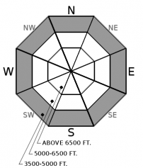
How to read the forecast
A powerful storm arrived overnight with increasing avalanche danger. New snow and wind are forming slabs 1-2’ thick at and above the treeline. Be alert for changing conditions as you gain elevation. Selecting wind-sheltered terrain away from areas harboring drifts of stiff, dense snow is today’s go-to. The chance of natural and triggered slides on buried weak layers increases during storms. Default to planar lower-angled slopes to successfully deal with this difficult problem.

3. Considerable
?
Above 6500 ft.
2. Moderate
?
5000-6500 ft.
2. Moderate
?
3500-5000 ft.
- 1. Low
- 2. Moderate
- 3. Considerable
- 4. High
- 5. Extreme
-
Type ?
-
Aspect/Elevation ?

-
Likelihood ?CertainVery LikelyLikelyPossible
 Unlikely
 -
Size ?HistoricVery LargeLargeSmall

Windy! For the past 30 hours, sustained winds have transported snow into slabs 1-2' thick. These slabs will grow in size and become more sensitive with today's new snow and wind. Strong gusts have moved some of this snow further downhill than what we are used to. Look for slabs in the usual spots below ridgelines and cross-loaded features, but don't let your guard down as you descend in elevation where slabs have recently been triggered mid-slope. Expect to find slabs that are harder than your normal storm wind slab. These may break above you and propagate further than expected. During wind events such as this, it is best to seek out sheltered terrain away from dense, stiff snow. Cracking or hollow sounding snow is a sign that you have found a slab.
-
Type ?
-
Aspect/Elevation ?

-
Likelihood ?CertainVery LikelyLikelyPossible
 Unlikely
 -
Size ?HistoricVery LargeLargeSmall

The danger of a natural or triggered Persistent Slab increases during loading events. Failure may occur on a faceted crust 1-2' below the surface, or worse, 3-4' down on another faceted crust. If you trigger one of these layers, the resulting slide will be large and dangerous. This is a difficult problem to assess, and the easiest way to manage this problem is with terrain selection. Sticking to slopes that appear to hold a deep snowpack devoid of scoured areas or visible rocks is a start. Avoiding convex slopes where the snowpack is pulling apart is another proven technique. Lastly, error on the side of caution with lower-angle terrain selection as the best way to ride during these uncertain times.
-
Type ?
-
Aspect/Elevation ?

-
Likelihood ?CertainVery LikelyLikelyPossible
 Unlikely
 -
Size ?HistoricVery LargeLargeSmall

Wet snow on steep slopes can pose a hazard today. You can trigger sluffs of dense debris that's hard to escape, turning small slopes above terrain traps into booby traps. Clear signs of this danger are rollerballs that release naturally or from your board or snowmachine. Avoid gully walls, cutbanks, and steep-sided creek beds.
Another potent storm barreled in overnight with warm temps, moderate to strong winds, rain at low-elevations, and snow above 4500-5000’. Snowfall intensifies through mid-morning when a cold front arrives drying out the atmosphere and dropping the temperatures back to more seasonable levels. As of 5:00 a.m., Flattop in central GNP has received the lion’s share with 1.1” of water and 5” of dense snow. (Here come old Flattop. He come grooving up slowly. He got joo joo eyeball. He one holy roller - the Beatles). The Whitefish Range has picked up a few inches of snow while the normally reliable Noisy Basin looks to miss most of the action with this fast-moving system. Wind speeds have been sustained moderate to strong for the past 30 hours, with the Mt Aeneas station reporting an average velocity of 44 mph with gusts into the 60’s.
We have elevated the avalanche danger across the board to CONSIDERABLE danger above treeline. If precipitation totals don't reach forecast amounts, expect slabs to be smaller in size and less dangerous. Wind slab is problem #1 today and the most obvious to find. Although the snowpack at low-elevations is thin, we bumped the danger up due to a rain-saturated surface. Our Persistent Slab problem remains the lurking danger. New snow and wind drifted snow will add weight to the snowpack and stress these buried weak layers. Today’s million-dollar question is will this load be enough to tip the balance and result in large dangerous slides? Will debris from wind slabs avalanches step down to these weak layers? Time will tell how today’s Persistent Slab problem will play out and the best way to handle this problem in uncertain times is defaulting to lower-angled terrain selection in wind-sheltered locations.
A warm and windy storm rolled in overnight. Precipitation will intensify through mid to later morning when a cold front arrives limiting moisture and dropping temperatures. Unsettled weather continues through the work week.
This forecast applies only to backcountry areas outside established ski area boundaries. The forecast describes general avalanche conditions and local variations always occur. This forecast expires at midnight on the posted day unless otherwise noted. The information in this forecast is provided by the USDA Forest Service who is solely responsible for its content.


