


For 5000 ft. to 7000 ft.
| Saturday | Saturday Night | Sunday | |
|---|---|---|---|
| Cloud Cover: | Mostly Cloudy | Mostly Cloudy | Mostly Cloudy |
| Temperatures: | 25 to 32 deg. F. | 21 to 26 deg. F. | 27 to 33 deg. F. |
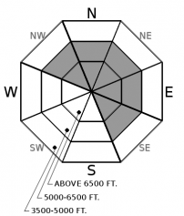
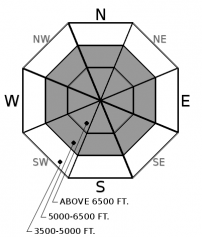
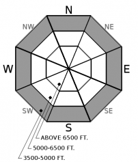
| Wind Direction: | Southwest | South | Southwest |
| Wind Speed: | 21G39 | 24G47 | 37G69 |
| Snowfall: | 2" to 4" in. | 7" to 9" in. | 4" to 5" in. |
| Snow Line: | 3500' | 3500' | 3000' |


