| Wednesday | Wednesday Night | Thursday | |
|---|---|---|---|
| Cloud Cover: | Mostly Cloudy | Mostly Cloudy | Mostly Cloudy |
| Temperatures: | 21 to 24 deg. F. | 18 to 21 deg. F. | 22 to 28 deg. F. |
| Wind Direction: | Southwest | Southwest | Southwest |
| Wind Speed: | 15G30 | 15G26 | 14G24 |
| Snowfall: | 1" to 4" in. | 2" to 4" in. | 1 to 2" in. |
| Snow Line: | 1500' | 2500' | 3000' |
Whitefish Range
Flathead Range and Glacier National Park
How to read the forecast
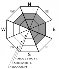
The chance of triggering small wind slabs on steep, leeward slopes will rise throughout the day. Watch for increasing snowfall and blowing snow as signs that drifts are getting denser and larger. Cracking in thick, drifted snow means that slabs are becoming unstable. You’re most likely to get into trouble below corniced ridgelines and on the sidewalls of gullies where more than 6 inches of new snow has drifted.

2. Moderate
?
Above 6500 ft.
2. Moderate
?
5000-6500 ft.
1. Low
?
3500-5000 ft.
- 1. Low
- 2. Moderate
- 3. Considerable
- 4. High
- 5. Extreme
-
Type ?
-
Aspect/Elevation ?

-
Likelihood ?CertainVery LikelyLikelyPossible
 Unlikely
 -
Size ?HistoricVery LargeLargeSmall

Westerly winds will drift new and recent snow into slabs below ridgelines and on the sidewalls of gullies. Watch for blowing snow as you gain elevation. Stiffer, rippled dunes can crack above the softer, lower density snow below. Use hand pits and test slopes to track whether slabs are forming and how well they are bonded to the underlying snow. Cracking on wind-loaded features means you should avoid bigger, steeper terrain.
-
Type ?
-
Aspect/Elevation ?

-
Likelihood ?CertainVery LikelyLikelyPossible
 Unlikely
 -
Size ?HistoricVery LargeLargeSmall

Persistent weak layers are buried under 1 to 4 feet of snow. The last report of an avalanche failing on one of these old, faceted crusts was on a southeast aspect around 7000 feet around Christmas time. Feedback from these layers has been inconsistent. Snowpack tests sometimes propagate above, and sometimes below, the crusts 2+ feet below the surface, and especially where the snowpack is thinnest. The most suspect trigger points are near rocky outcrops and convex rolls where the snowpack is stretched and shallower. This is where you are more likely to trigger a dangerously large slab. Plan to limit your exposure to that kind of terrain as new and drifted snow puts an additional load on the snowpack.
Observers over the past week have reported sporadic storm slab and loose dry avalanches. Yesterday, I was able to trigger a small wind slab in the southern Whitefish Range. The last avalanche failing on older weak layers likely failed around Christmas on a southeast aspect near Essex.
As new snow begins to accumulate throughout the day, it will fall on light, settled powder across the region, and patches of surface hoar in the Swan Range. That means it may have trouble bonding to the old surface. Westerly winds will be enough to stiffen slabs on leeward terrain, below ridgelines and saddles, and in cross-loaded gullies. Temperatures will increase a few degrees making the new snow slightly upside-down. New and drifted snow that is denser than what’s underneath can crack and slide on steep terrain. It can break wider than expected where it buries a fragile, feathery layer of surface hoar.
Weak layers buried up to 4 feet deep remain a secondary, but consequential, concern. A crust that was buried on the 22nd peters out and becomes sugary around 5500 to 6000 feet. Above that elevation, there is the off chance of triggering a deeper, larger slab. Facets around crusts buried earlier this month are found on just about every aspect. Snowpack tests continue to show propagating failures where the snowpack is shallower. The most suspect terrain for persistent slab avalanches is on southerly and easterly slopes, near rocky outcrops, and where the snowpack is stretched over convexities. I will think twice about exposing myself to that kind of terrain as more snowfall reloads buried weak layers.
A winter weather advisory will be in effect from 11pm tonight through 11am Thursday. LIght snowfall this morning will increase in intensity into tomorrow. The heaviest accumulations are expected in the Swan Range. Ridgetop winds will be moderate. Unsettled weather continues for the rest of the week with a strong warm front bringing Pacific moisture and stronger wind into the area by Sunday.
This forecast applies only to backcountry areas outside established ski area boundaries. The forecast describes general avalanche conditions and local variations always occur. This forecast expires at midnight on the posted day unless otherwise noted. The information in this forecast is provided by the USDA Forest Service who is solely responsible for its content.


