| Tuesday | Tuesday Night | Wednesday | |
|---|---|---|---|
| Cloud Cover: | Mostly Cloudy | Mostly Cloudy | Mostly Cloudy |
| Temperatures: | 15 to 20 deg. F. | 12 to 16 deg. F. | 22 to 25 deg. F. |
| Wind Direction: | West | Southwest | Southwest |
| Wind Speed: | 10G22 | 13 | 16G30 |
| Snowfall: | 0" in. | 0" in. | 1" to 2" in. |
| Snow Line: | 500' | 500' | 1500' |
Whitefish Range
Swan Range
Flathead Range and Glacier National Park
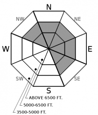
How to read the forecast
Continue to approach terrain carefully at middle and upper elevations. This is where the wind has thickened slabs and weak snow is buried deep in the snowpack. Ride around pillowy, textured looking surfaces below corniced ridgelines and cross-loaded terrain features. Ride one at a time and choose slopes that are planar or concave with runouts that are free of trees or other terrain traps.

2. Moderate
?
Above 6500 ft.
2. Moderate
?
5000-6500 ft.
1. Low
?
3500-5000 ft.
- 1. Low
- 2. Moderate
- 3. Considerable
- 4. High
- 5. Extreme
-
Type ?
-
Aspect/Elevation ?

-
Likelihood ?CertainVery LikelyLikelyPossible
 Unlikely
 -
Size ?HistoricVery LargeLargeSmall

Observers continue to trigger small avalanches on leeward facing aspects. Identify and steer around slopes below corniced ridgelines, or areas that appear rippled or pillowy. These are the places you are more likely to tango with a slab avalanche that is up to a foot thick. A safer and higher quality experience will be in terrain that is sheltered from the wind.
-
Type ?
-
Aspect/Elevation ?

-
Likelihood ?CertainVery LikelyLikelyPossible
 Unlikely
 -
Size ?HistoricVery LargeLargeSmall

Triggering a large, hard slab avalanche that breaks up to 4 feet deep is unlikely, but not impossible. If triggered, these avalanches would be large enough to bury and injure you. Give yourself a wide margin for error if your travels take you above roughly 5500 feet. Be cautious around slopes that are rocky and have steep rollovers. This is the kind of terrain where you are more likely to collapse a weak layer buried deeper in the snowpack causing a much larger and more dangerous avalanche.
Since the December 22nd avalanche cycle, we have received seven reported storm slab and loose dry avalanches. One of these avalanches was large enough to bury and injure you. Human triggered avalanches from the 27th and the 28th are friendly reminders that recently formed slabs still exist in specific areas. Avalanche activity is most common on leeward facing slopes where wind drifted snow into thicker slabs. Recent avalanche activity is bullseye information and should be utilized in decision making throughout the day.
Periods of good visibility over the past week allowed riders to observe the wreckage of the warm, wet, and windy event from December 21 and 22. Walking through the mountains and looking at big debris fields and crowns reminds me to acknowledge the destructive power of avalanches. It also reminds me to acknowledge the importance of timing. When to go, when to stay home, or maybe when to just enjoy slopes that are 25 degrees in steepness. Timing is everything.
Seven days have passed since the last known persistent slab avalanche. The snowpack is becoming more stable, but we're not out of the woods yet. Be cautious at elevations where the 12/22 crust is not present or is breakable. This elevation seems to be above roughly 5500' to 6000'. You are far less likely to collapse a weak layer further down in the snowpack where this crust is supportable. The main concern would be hitting a thin spot on a slope where deeply buried weak layers are closer to the surface. These areas would be near rock outcroppings and convex rolls. I am still giving myself a wide margin for error at this time. If your decisions lead you into steep terrain, choose slopes that are planar or concave with runouts that are free of trees and other terrain traps.
Today will be partly cloudy with temperatures in the low to mid twenties. Winds will be light with gusts up to 20 mph at the highest ridgelines.
This forecast applies only to backcountry areas outside established ski area boundaries. The forecast describes general avalanche conditions and local variations always occur. This forecast expires at midnight on the posted day unless otherwise noted. The information in this forecast is provided by the USDA Forest Service who is solely responsible for its content.


