| Monday | Monday Night | Tuesday | |
|---|---|---|---|
| Cloud Cover: | Mostly Cloudy | Mostly Cloudy | Partly Cloudy |
| Temperatures: | 20 to 25 deg. F. | 8 to 12 deg. F. | 15 to 20 deg. F. |
| Wind Direction: | Southwest | West | West |
| Wind Speed: | 10 | 10 | 10 |
| Snowfall: | 0" in. | 0" in. | 0" in. |
| Snow Line: | 2000' | 1500' | 500' |
Whitefish Range
Swan Range
Flathead Range and Glacier National Park
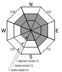
How to read the forecast
Triggering an avalanche that breaks up to 4 feet deep on buried weak layers remains a possibility. These slides have the potential to be large, dangerous, and destructive. Surface instabilities from our recent storm can prove troublesome in areas affected by the wind. Choose terrain carefully to enjoy today's nice weather. Planar or concave slopes with good runouts are always a good bet. Areas sheltered from the wind will provide a generally safer and more enjoyable experience.

2. Moderate
?
Above 6500 ft.
2. Moderate
?
5000-6500 ft.
1. Low
?
3500-5000 ft.
- 1. Low
- 2. Moderate
- 3. Considerable
- 4. High
- 5. Extreme
-
Type ?
-
Aspect/Elevation ?

-
Likelihood ?CertainVery LikelyLikelyPossible
 Unlikely
 -
Size ?HistoricVery LargeLargeSmall

Despite a strengthening surface snowpack, you can still trigger an avalanche on layers buried 1-4’ deep. The resulting slides will be large and dangerous. With good visibility today, take a moment to familiarize yourself with the potential trigger points on a slope. Weak areas include steep rollovers where stress is concentrated in the pack and thin areas that allow you or your machine to impact the underlying layer readily. Safer terrain choices are slopes with a planar or concave profile and areas that appear deeper and do not have a peppered appearance from rocks sticking out of the snow or a thin windswept look.
-
Type ?
-
Aspect/Elevation ?

-
Likelihood ?CertainVery LikelyLikelyPossible
 Unlikely
 -
Size ?HistoricVery LargeLargeSmall

Continued temperate weather is decreasing the chance of triggering an avalanche at the surface. However, the exception is on steep wind affected slopes where the snow feels stiff and has a rippled appearance. The danger will increase in areas where the slab approaches 8" thickness or ends in a terrain trap, or the runout is filled with trauma-inducing surface obstacles. It is safer and more fun to enjoy the soft snow in areas unaffected by the wind, such as gladed terrain. If your goal is to summit a peak, remaining on the windward aspects will improve your margin of safety.
The weekend storm arrived warm, wet, and apparently in a hurry to get out of town. Over 1” of water (SWE) in roughly 30 hours was reported in the Whitefish and Swan Range. Typically, a heavy hitter like this creates a bit of havoc with our snowpack, but so far, just four small slides reported. Why? The main reason is the Atmospheric River moisture event, which preceded this storm by several days. This warm, wet system delivered a heart punch to the snowpack with heavy, wet snow and rain. This left it worked over, so there just wasn’t much for the weekend storm to beat up. Reason two is that this weekend’s storm came in warm and bonded relatively well to the underlying layers, which weekend observations verified.
Cam noted no shortage of slabs and wind affected snow in the low-elevation open basin in Cascadilla, but he found these glued in and had no luck getting any to budge. A multi-day observation from the northern Whitefish Range remarked that upper elevation winds formed stubborn wind slabs above 7000', but they found good snow quality and stability in the trees. 2 reports from Marion Lake mentioned soft snow, minimal wind effect, and few signs of instability. In Glacier Park Saturday, I found poor quality shears in hand pits involving the new snow and generally soft conditions, especially in sheltered locations. The common theme in many of these observations is the snow’s high quality and good stability in areas sheltered from the wind. This is why we frequently mention the benefits of wind-sheltered terrain in our daily forecast and try to steer recreationists in that direction. Monday’s dry, mild air allowed the storm snow to strengthen further. You can still find areas where you could trigger a slide at the snow surface, but they are getting more difficult to find.
We first listed the Persistent Slab as a problem on December 19 following several days of human-triggered avalanches outside the boundary of Whitefish Mountain Resort. The Atmospheric River event put this problem on display with numerous large avalanches across our area. As expected, this problem won’t be going away anytime soon. Blase gave us a Christmas gift with his history lesson on our current Persistent Slab problem, which can be found here. Yesterday, Cam found the 12/9 crust improving while Clancy did not have any results on that layer but recorded ECTN below the 12/22 crust. We will continue to monitor both of these layers as our snowpack evolves.
Mild temperatures, light winds, and periods of sunshine are on tap for today. Snow flurries return tomorrow with cooler, cloudier weather. A stronger system may impact our area starting Wednesday night.
This forecast applies only to backcountry areas outside established ski area boundaries. The forecast describes general avalanche conditions and local variations always occur. This forecast expires at midnight on the posted day unless otherwise noted. The information in this forecast is provided by the USDA Forest Service who is solely responsible for its content.


