| Saturday | Saturday Night | Sunday | |
|---|---|---|---|
| Cloud Cover: | Mostly Cloudy | Mostly Cloudy | Mostly Cloudy |
| Temperatures: | 25 to 29 deg. F. | 18 to 21 deg. F. | 24 to 32 deg. F. |
| Wind Direction: | Southwest | West | West |
| Wind Speed: | 14G26 | 13G25 | 13 |
| Snowfall: | 4" to 8" in. | 4 to 8" in. | 0" in. |
| Snow Line: | 4000' | 2500' | 1500' |
Swan Range
How to read the forecast
Fresh snow and gusty winds today are creating new snow avalanche hazards on steep slopes. You can trigger soft slabs that will grow wider and thicker as the day develops. Don't let this visible hazard distract you from the potential for triggering slabs that break up to four deep on weak layers buried earlier this month. Stick to lower-angled, planar slopes with clean runouts.

2. Moderate
?
Above 6500 ft.
2. Moderate
?
5000-6500 ft.
1. Low
?
3500-5000 ft.
- 1. Low
- 2. Moderate
- 3. Considerable
- 4. High
- 5. Extreme
-
Type ?
-
Aspect/Elevation ?

-
Likelihood ?CertainVery LikelyLikelyPossible
 Unlikely
 -
Size ?HistoricVery LargeLargeSmall

Soft slabs of new and drifted snow can be dangerous today on steep slopes where they're more than about 8 inches thick, or on steep slopes above terrain traps. They'll typically break at the old snow/ new snow interface, or a few inches below, at the rain crust left Tuesday morning. Assessing this hazard is straightforward. Probing with a pole can tell you how much snow has accumulated. Shearing off a block with your hand can give you a sense of whether the new snow is a cohesive slab. Test slopes can tell you whether a slab is sensitive to your weight or the weight of your snowmachine. And of course, cracks, collapses, and fresh avalanches are clear signs of instability and danger.
-
Type ?
-
Aspect/Elevation ?

-
Likelihood ?CertainVery LikelyLikelyPossible
 Unlikely
 -
Size ?HistoricVery LargeLargeSmall

Limit your chances and consequences of triggering slabs that break 1 to 4 feet deep on weak snow around crusts buried 12/22 or 12/9. Choose slopes less than 35 degrees in steepness that aren't above terrain traps. Pick lines that avoid potential trigger points where the snowpack is thin. Pay particular attention to avoiding mid-slope breakovers, because that's the terrain configuration where many reported slides have released. And keep your partners in sight.
New and drifted snow is accumulating above a variety of weak and slick old snow surfaces, such as surface hoar, wind-hardened crusts, or low-density snow. While the accumulating snow will likely be sensitive to the weight of a person or snowmachine today, triggered slabs will generally be thin and not involve enough snow to bury a person. The exceptions will be the isolated slopes where 8 inches or more of new and drifted snow has accumulated, or where thin slabs exist above terrain traps. Expect the hazard to develop sooner and be more widespread as you gain elevation today. At mid elevations, low-density snow above the 12/22 crust are a recipe for easily-triggered thin slabs or sluffs running long distances.
A bigger concern is slabs breaking deeper in the snowpack. A quick review of how that developed, so the whys and wherefores today's forecast click. A dry spell ended 12/9, when snowfall began accumulating above a melt-freeze crust that extends to at least 7000 feet across the region. Over two weeks of regular snowfall, dense slabs roughly 1.5 to 4 feet thick accumulated above this crust. A natural avalanche cycle occurred during a warm, wet, and windy Solstice storm. That also left a rain crust up to about 6000 feet in the northern half of the region, and about 6500 feet in the southern half. Those two crusts, and the weak snow above and below them, remain our prime suspects for triggered slides going forward, though a few other persistent weak layers are spottily distributed across the region at similar depths.
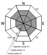
Since early December, recorded avalanches have almost exclusively occurred on slopes that face northwest through northeast to southeast. People have reported only one slide from south through west slopes, and less frequent signs of instability. However, the 12/9 crust and facets structure exists there too. Slabs above that crust/ weak layer structure are thinner on south through west aspects (1 to 2 feet as opposed to 2 to 4), and that may account for the lack of avalanche activity there. Additional loading, like the snowfall forecast for today and tonight, may be enough to activate the 12/9 crust/ facets on south through west aspects, so I've added them back into the Persistent Slab aspect/ elevation rose. Today's snowfall probably isn't enough to activate weak snow below the 12/22 rain crust except where it's thin. That's about the upper 500 feet of its extent.
The upshot of this history? There's a lingering hazard of triggering slabs that break below today's new snow/ old snow interface. We're not in Colorado anymore, Toto, so this hazard isn't as hair-trigger sensitive. It's also not as obvious. So it's important to maintain practices that limit the likelihood and consequences of triggering slabs that break well below the snow surface.
Snowfall will continue this morning before tapering off to showers as the upper air flow veers from southwest to northwest. Another pulse of snow fall is forecast for tonight. The snowfall should favor the Swan Range. Winds look to be gusty - average in the low teens but gusts of 25 to 30.
This forecast applies only to backcountry areas outside established ski area boundaries. The forecast describes general avalanche conditions and local variations always occur. This forecast expires at midnight on the posted day unless otherwise noted. The information in this forecast is provided by the USDA Forest Service who is solely responsible for its content.


