| Friday | Friday Night | Saturday | |
|---|---|---|---|
| Cloud Cover: | Partly Cloudy | Mostly Cloudy | Mostly Cloudy |
| Temperatures: | 24 to 29 deg. F. | 18 to 22 deg. F. | 23 to 29 deg. F. |
| Wind Direction: | Southwest | South | Southwest |
| Wind Speed: | 11 | 13 | 16G30 |
| Snowfall: | 0" in. | 2" to 3" in. | 3" in. |
| Snow Line: | 1500' | 1500' | 2500' |
Swan Range
How to read the forecast
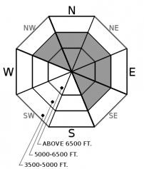
You're most likely to find trouble and miss your holiday dinner on near- and above-treeline slopes that face northwest through northeast to southeast. In this terrain, you can trigger slabs that break 2-4 feet deep on weak, old snow. You can also trigger freshly formed slabs of drifted snow near summits and exposed ridges. Avoiding steep slopes is the most straightforward way of keeping safe. Stick to slopes less than 35 degrees and pick lines that avoid likely trigger points.

2. Moderate
?
Above 6500 ft.
2. Moderate
?
5000-6500 ft.
1. Low
?
3500-5000 ft.
- 1. Low
- 2. Moderate
- 3. Considerable
- 4. High
- 5. Extreme
-
Type ?
-
Aspect/Elevation ?

-
Likelihood ?CertainVery LikelyLikelyPossible
 Unlikely
 -
Size ?HistoricVery LargeLargeSmall

The distribution of natural avalanches, triggered slides, and other signs of instability are concentrated on slopes that face northwest through northeast to southeast, with a few outliers. Unfortunately, that's the terrain that also harbors the best snow, after a sun crust formed Thursday. So limit the chances and consequences of triggering a slab that breaks 2 to 4 feet deep. Choose slopes that are less than 35 degrees in steepness that aren't above terrain traps. Pick lines that avoid likely trigger points: anywhere the snowpack is thin, such as convex breakovers and patches of thin snow above buried rocks. Stop in places where you're clear of slides running down on top of you. And keep your partners in sight.
-
Type ?
-
Aspect/Elevation ?

-
Likelihood ?CertainVery LikelyLikelyPossible
 Unlikely
 -
Size ?HistoricVery LargeLargeSmall

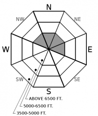
Above about 7000 feet, expect to find freshly-formed slabs of drifted snow that could be triggered by a person or a snowmachine. Expect these in places prone to collecting wind-blown snow: the tops of couloirs, the downwind sides of chutes and passes, and just below ridges on their leeward sides. In terrain like this, look for dune shaped drifts or surface snow etched by wind and littered with conifer needles. Steer around slopes where the snow feels thicker and chalkier than the low density snow that's prevalent elsewhere. With winds forecast to decrease through the day, expect these to slowly stabilize.
Merry Crust-mas! The heat from Santa's sled engines left a thin crust on steep mid and upper elevation slopes that received direct sun Thursday. And people are reporting the rain crust from Tuesday morning extends to 5900 or 6500 feet, depending on location. It's generally higher in the southern half of our region.
More significantly, our primary avalanche hazard involves crust and facet combinations. With good visibility Thursday, crowns from a cycle of natural avalanches were visible in the Flathead and Whitefish Ranges. The slides released deep in the snowpack, likely on crusts and weak snow that formed in November or early December. The natural slides were mostly large - D2-2.5 - with a few very large slides - D3s. In general, they failed between 6500 and 7000 feet, on northwest- through northeast-facing slopes, with a few outliers on east- and southeast-facing slopes. And many failed well-below ridgelines or summits. If that description hasn't convinced you to avoid terrain like this for the moment, Santa's waxing your boards and filling your tank with a lump of coal.
One primary suspect for the failure plane in the natural avalanche cycle is a crust buried Dec. 9; it typically shows up in snowpits as a gray, dirty layer 20-30 inches below the snow surface. It's regularly (but not always) propagating in large column tests, mostly with hard force. The crust's thickness and strength vary with elevation and location. Tuesday, I found a crust 5 inches thick with no facets above it. Wednesday, a layer of facets below the crust failed in my test. Thursday, it was a layer of facets and depth hoar above it that failed. Each pit was higher than the previous one (6200-7000 feet) Other people have reported similar variability.
There's less variability in the aspects where avalanches and signs of instability are occurring. Nearly all of the avalanches reported the past few days have failed on slopes facing northwest through northeast to southeast. There was one outlier on a southwest-facing, mid elevation slope. Most of the propagation reported in tests is on the same aspects, and most of the slides and signs of instability have occurred in the transition between near- and above-treeline terrain. The range is roughly 6000 to 7000 feet. So we've trimmed the Persistent Slab aspect/ elevation rose to those aspects and elevations. The variability in the sensitivity makes an Extended Column Test a good idea before committing to any steep slope.
Happy and safe holidays, all!
After morning fog and clouds dissipate, expect a partly sunny day with mild temperatures in the mountains, generally light winds with moderate gusts. A warm front arriving later today will bring light snow to the region tonight and early tomorrow, with increasing winds Saturday.
This forecast applies only to backcountry areas outside established ski area boundaries. The forecast describes general avalanche conditions and local variations always occur. This forecast expires at midnight on the posted day unless otherwise noted. The information in this forecast is provided by the USDA Forest Service who is solely responsible for its content.


