THIS AVALANCHE FORECAST EXPIRED ON December 22, 2020 @ 11:56 pm
Avalanche Forecast published on December 22, 2020 @ 6:56 am
Issued by Cam Johnson - Flathead Avalanche Center

Whitefish Range
Swan Range
Flathead Range and Glacier National Park

How to read the forecast

A special avalanche bulletin has been issued for the region today. Complex and dangerous avalanche conditions exist. Overnight rain and warm temperatures have weakened the snowpack. Snowfall and wind today may create easily-triggered new slabs. Natural and triggered avalanches may entrain wet snow and run long distances, making them more dangerous. Use caution and conservative decision-making to avoid avalanche start zones and runouts. 

3. Considerable

?

Above 6500 ft.
Dangerous avalanche conditions. Careful snowpack evaluation, cautious route-finding and conservative decision-making essential.

3. Considerable

?

5000-6500 ft.
Dangerous avalanche conditions. Careful snowpack evaluation, cautious route-finding and conservative decision-making essential.

2. Moderate

?

3500-5000 ft.
Heightened avalanche conditions on specific terrain features. Evaluate snow and terrain carefully; identify features of concern.
    Dangerous avalanche conditions. Careful snowpack evaluation, cautious route-finding and conservative decision-making essential.
  • 1. Low
  • 2. Moderate
  • 3. Considerable
  • 4. High
  • 5. Extreme
Avalanche Problem 1: Persistent Slab
  • Type ?
  • Aspect/Elevation ?
  • Likelihood ?
    Certain
    Very Likely
    Likely
    Possible
    Unlikely
  • Size ?
    Historic
    Very Large
    Large
    Small

Recent avalanches are your warning to stay off of, and out from underneath slopes that are roughly 35 degrees or steeper today. We have received reports each of the past 6 days of human-triggered avalanches. Most of these are failing on weak layers buried 1 to 2 feet below the surface. The combination of rain, new snow, and drifting snow creates the possibility that slabs may release lower in the snowpack, creating larger, more dangerous avalanches.

Avalanche Problem 2: Storm Slab
  • Type ?
  • Aspect/Elevation ?
  • Likelihood ?
    Certain
    Very Likely
    Likely
    Possible
    Unlikely
  • Size ?
    Historic
    Very Large
    Large
    Small

Today, expect storm slabs to grow thicker and more dangerous as new snow continues to fall. Expect storm slabs to be most dangerous on leeward aspects where strong winds drifted snow into a thicker, harder slabs. Cracking in new snow is a sign to stay off of steeper, more consequential terrain. There is a possibility of a smaller avalanche stepping down to a more dangerous, persistent slab avalanche.

Avalanche Problem 3: Loose Wet
  • Type ?
  • Aspect/Elevation ?
  • Likelihood ?
    Certain
    Very Likely
    Likely
    Possible
    Unlikely
  • Size ?
    Historic
    Very Large
    Large
    Small

Rain and above freezing temperatures overnight have weakened the snowpack. Choose a route where you do not cross underneath large avalanche paths today. Natural avalanches from high-elevation start zones will entrain wet snow as they gain momentum. This will cause avalanches to run further and be much more destructive.

Forecast discussion

Early this morning, remote weather stations above 6000 feet are showing continued precipitation with temperatures above freezing. I will not be surprised to see we went through a large natural avalanche cycle overnight. Temperatures will slowly drop throughout the morning. This should severely alter your travel plans today. Stay out from underneath large avalanche paths. Any triggered avalanche up high will entrain wet snow as it gains momentum. Wet debris may run long distances and be more destructive. These are nothing to mess with.

In the past weak, we have received reports of both human triggered, and natural avalanches that were large enough to bury and injure a person from all three of our forecast zones. Most of these avalanches are failing on a faceted crust or surface hoar buried 1 to 2 feet down. Yesterday, mitigation work at Whitefish Mountain Resort produced sizable avalanches with explosives and ski cuts. The difference in these avalanches was that they failed on facets above the early November crust, taking out most of the season's snowpack. One of these avalanches was remotely triggered while ski cutting. This is clear evidence that we have a complicated snowpack. The weather oday will continue to test these weak layers. Find places to recreate that do not expose you and your party to overhead hazards, and steer away from avalanche start zones.

You will likely feel the winds shift to the north by late morning. During this time expect bands of heavy snowfall and dropping temperatures. Although the timing is uncertain, cooling temperatures will help lock the snowpack in place. Afterward, we will primarily be dealing with surface snow hazards.

Weather and CURRENT CONDITIONS
weather summary

Snow levels this morning will hover around 6000 feet. An arctic airmass is expected to engulf our forecast area by 11 AM bringing cooling temps and northerly winds.

Two-Day Mountain Weather Forecast Produced in partnership with the Missoula NWS
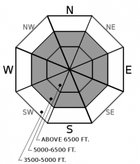
For 5000 ft. to 7000 ft.
Tuesday Tuesday Night Wednesday
Cloud Cover: Mostly Cloudy Mostly Clear Partly Cloudy
Temperatures: 21 to 28 deg. F. 4 to 9 deg. F. 14 to 20 deg. F.
Wind Direction: North Northwest West
Wind Speed: 23G36 11G22 13G24
Snowfall: 5" in. 0" in. 0" in.
Snow Line: 1000' 0' 0'
Disclaimer

This forecast applies only to backcountry areas outside established ski area boundaries. The forecast describes general avalanche conditions and local variations always occur. This forecast expires at midnight on the posted day unless otherwise noted. The information in this forecast is provided by the USDA Forest Service who is solely responsible for its content.