THIS AVALANCHE FORECAST EXPIRED ON December 15, 2020 @ 11:55 pm
Avalanche Forecast published on December 15, 2020 @ 6:55 am
Issued by Mark Dundas - Flathead National Forest

Whitefish Range
Swan Range
Flathead Range and Glacier National Park

How to read the forecast

The avalanche danger may rise as the first in a series of storms impacts our area. Thin slabs may develop downwind of ridgelines and in cross-loaded gullies—monitor new snow totals and blowing snow as you gain elevation. Investigate slopes with a pillowy or thicker look before committing. Opt for slopes out of the wind if you find cracking or stiff snow. Manage sluffs on steep slopes, especially above terrain traps or cliffs. 


2. Moderate

?

Above 6500 ft.
Heightened avalanche conditions on specific terrain features. Evaluate snow and terrain carefully; identify features of concern.

1. Low

?

5000-6500 ft.
Generally safe avalanche conditions. Watch for unstable snow on isolated terrain features.

1. Low

?

3500-5000 ft.
Generally safe avalanche conditions. Watch for unstable snow on isolated terrain features.
    Heightened avalanche conditions on specific terrain features. Evaluate snow and terrain carefully; identify features of concern.
  • 1. Low
  • 2. Moderate
  • 3. Considerable
  • 4. High
  • 5. Extreme
Avalanche Problem 1: Wind Slab
  • Type ?
  • Aspect/Elevation ?
  • Likelihood ?
    Certain
    Very Likely
    Likely
    Possible
    Unlikely
  • Size ?
    Historic
    Very Large
    Large
    Small

Today’s snow and wind may form small, shallow slabs on leeward slopes. They will be thickest, and most dangerous, below ridgelines, saddles, and in gullies. Where deposited on weak layers or crusts, these may propagate wider and run further than expected. Stiffer feeling snow should alert you to changing conditions. Cracks under your machine or feet are confirmation that you are on an unstable slab. You can avoid these conditions by sticking to sheltered or windward terrain.

Avalanche Problem 2: Loose Dry
  • Type ?
  • Aspect/Elevation ?
  • Likelihood ?
    Certain
    Very Likely
    Likely
    Possible
    Unlikely
  • Size ?
    Historic
    Very Large
    Large
    Small

As snow totals pile up, the chance of triggering a loose slide increases—especially where you find 8” or more cohesionless surface snow on steep slopes. Some areas will have an underlying crust inhibiting bonding and allowing slides to travel further than expected. You can attempt to manage your sluffs, provided you are not above a terrain trap. A less stressful option is to head for low-angle terrain where the snow will not only be safer but probably deeper, as well.

Forecast discussion

FAC staff has been tracking near-surface conditions in anticipation of a return to a snowier weather pattern and rising avalanche conditions. Observers have noted a weak, faceted, low-density snow surface that is generally 2-8” thick at mid and upper elevations. This snow rests on a slick melt-freeze crust that formed December 8 in many locations. Therefore, as Blase mentioned yesterday, we have two of the three ingredients necessary for a slab avalanche--a bed surface and a weak layer. The third ingredient, the slab, is potentially on the way as a series of warm Pacific storms are poised to enter our area through the weekend. 

The current storm inched in this morning with slowly rising temperatures, light snow showers, and increasing westerly winds. Accumulations as of 6:00 am are nil to an inch or so at mountain weather stations. The bulk of the moisture arrives later and overnight with a winter weather advisory on tap from 3 p.m. until 5 am tomorrow. Most mountain locations will receive a much-needed refresh of 4-8” by tomorrow morning.

The snowpack is generally stable this morning, but if moisture arrives earlier or delivers more snowfall than expected, the avalanche danger will rise to MODERATE at upper elevations. If the storm fails to deliver much snow during the day, the threat will increase overnight into tomorrow. 

New snow should be denser with increasing wind and warming temperatures than the snow it will fall on, resulting in an upside-down snow surface, which will exacerbate the avalanche danger. Stick your hand or a ski pole into the snow to find this structure. Monitor the depth of new and windblown snow and use your hand, skis, or machine to test how it bonds to the underlying layer.

Our friends at Patagonia are helping us and the Friends of the Flathead Avalanche Center with a special showing of their latest film, Solving for Z. We're stoked to have the heart of the film, Zahan Billimoria, with us to chat about his experience and answer questions from a virtual audience. Join us on Monday, December 21st, from 6:00 to 7:30 MST for this special event. Learn more and get tickets here.

Weather and CURRENT CONDITIONS
weather summary

Unsettled weather entered our area overnight with precipitation increasing through the day and overnight. We get a short-lived break from moisture tomorrow before another system moves in tomorrow night. Models continue to depict a potential atmospheric river affecting our area this weekend.

Two-Day Mountain Weather Forecast Produced in partnership with the Missoula NWS
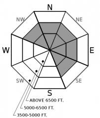
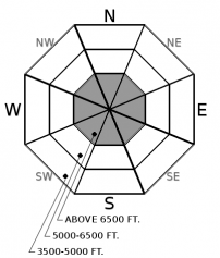
For 5000 ft. to 7000 ft.
Tuesday Tuesday Night Wednesday
Cloud Cover: Mostly Cloudy Mostly Cloudy Mostly Cloudy
Temperatures: 18 to 23 deg. F. 16 to 19 deg. F. 23 to 27 deg. F.
Wind Direction: West Southwest Southwest
Wind Speed: 10 14G26 17G36
Snowfall: 2-4" in. 2-4" in. 0-2" in.
Snow Line: 1500' 1500' 1500'
Disclaimer

This forecast applies only to backcountry areas outside established ski area boundaries. The forecast describes general avalanche conditions and local variations always occur. This forecast expires at midnight on the posted day unless otherwise noted. The information in this forecast is provided by the USDA Forest Service who is solely responsible for its content.