| Monday | Monday Night | Tuesday | |
|---|---|---|---|
| Cloud Cover: | Mostly Cloudy | Mostly Cloudy | Mostly Cloudy |
| Temperatures: | 18 to 23 deg. F. | 16 to 19 deg. F. | 23 to 27 deg. F. |
| Wind Direction: | West | Southwest | Southwest |
| Wind Speed: | 10 | 14G26 | 17G36 |
| Snowfall: | 0" in. | 0" in. | 3" to 4" in. |
| Snow Line: | 1500' | 1500' | 1500' |
Whitefish Range
Swan Range
Flathead Range and Glacier National Park
How to read the forecast
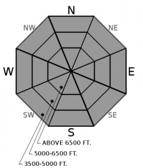
You're most likely to stumble into today's isolated avalanche hazards in steep, upper-elevation terrain. Triggered sluffs and small wind slabs in this terrain can have serious consequences if they sweep you into or over cliffs, rock, trees, or gullies. The avalanche danger will rise steadily through the week as a parade of weak storms brings snow and stronger winds to the forecast region. Monitor changing conditions by reading each day's forecast.

1. Low
?
Above 6500 ft.
1. Low
?
5000-6500 ft.
1. Low
?
3500-5000 ft.
- 1. Low
- 2. Moderate
- 3. Considerable
- 4. High
- 5. Extreme
-
Type ?
-
Aspect/Elevation ?

-
Likelihood ?CertainVery LikelyLikelyPossible
 Unlikely
 -
Size ?HistoricVery LargeLargeSmall

Be alert for small but isolated avalanche hazards, particularly above terrain traps where small slides can have outsized consequences. Where you find loose snow at the surface, you can trigger sluffs of dry snow on slopes steeper than about 38 degrees. These can run fast and far on slick crusts and pile up deep enough to bury a person where they involve about 8 inches or more of loose snow. Near ridgecrests and summits, you may be able to trigger hard slabs of drifted snow that sit on soft, weak, sugary snow. Pockets of surface hoar may have survived this week's warming and wind in sheltered, mid-elevation, shaded slopes throughout the region. Evaluate each steep slope you plan to climb or ride for these isolated hazards and the potential for serious consequences.
Some parts of the forecast region managed to wring a trace to a few inches of new snow out of Sunday's clouds. The big winner in the penny-ante poker game was Noisy Basin, with 3 to 4 inches. The Whitefish Range saw an inch or less, while a trace to 3 inches fell in the Flathead Range, Glacier National Park, and Marias Pass. This low-density snow adds to the loose snow at the snow surface, but doesn't create new avalanche problems. The one exception may be the crest of the Swan Range, where moderate winds may have drifted the new snow into thin, isolated slabs.
What jumps out at me in observations from the past few days are descriptions of loose, dry snow sitting on a slick crust. Observers generally report 2 to 4 inches of faceting snow and a melt-freeze crust extending into upper elevations on many aspects. For now, that combination means Dry Loose Snow avalanches that are unlikely to pile up deep enough to bury a person. They may, however, run fast and far, increasing the chances of injury if you're knocked off your feet and swept into trees or rocks. Looking ahead, the loose snow and crust are two components for slab avalanches: a weak layer and a bed surface. The missing third component, a slab, may develop this week, as new and drifted snow accumulate. That creates the potential for dangerous avalanches.
Observations indicate that the melt-freeze crust isn't present on northerly slopes above about 5800 feet. The snow on these aspects didn't get wet during the warm, sunny weather on Dec. 8. The layer of weak, loose snow is thicker - up to 8 inches in the northern Whitefish Range. Any triggered sluffs today on this shaded terrain will involve notably more moving snow and debris, increasing the chances of a burial. A slab deposited on this thicker layer of loose snow may not prove as troublesome.
I'm looking beyond the danger posed by today's surface conditions because weather models show a series of weak storms approaching our region. As new and wind-drifted snow accumulate through the week, the avalanche danger will rise. The primary failure plane for avalanches will likely be today's near surface facets and crust. There are few weak layers buried deeper in the snowpack. One exception is a thin ice lens deposited in mid-November; it's roughly a foot below the snow surface and is sandwiched between softer, weaker snow. While this structure hasn't been reactive in tests the past few days, it may activate with a steady accumulation of snow.
Our friends at Patagonia are helping us and the Friends of the Flathead Avalanche Center with a special showing of their latest film, Solving for Z. We're stoked to have the heart of the film, Zahan Billimoria, with us to chat about his experience and answer questions from a virtual audience. Join us on Monday, December 21st at 6:00 to 7:30 MST for this special event. Learn more and get tickets here.
Another day of light winds, flurries, and cool temps before a series of weak storms arrives. Over the next few days, these storms will bring stronger winds, light snow, and warming temperatures to the region. A very warm, wet system may cap the parade this weekend.
This forecast applies only to backcountry areas outside established ski area boundaries. The forecast describes general avalanche conditions and local variations always occur. This forecast expires at midnight on the posted day unless otherwise noted. The information in this forecast is provided by the USDA Forest Service who is solely responsible for its content.


