


For 5000 ft. to 7000 ft.
| Thursday | Thursday Night | Friday | |
|---|---|---|---|
| Cloud Cover: | Mostly Cloudy | Mostly Cloudy | Mostly Cloudy |
| Temperatures: | 21 to 28 deg. F. | 14 to 17 deg. F. | 19 to 24 deg. F. |
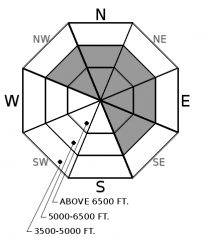
| Wind Direction: | West | Northeast | Southeast |
| Wind Speed: | 6 | 11 | 10 |
| Snowfall: | 0" in. | 0" in. | 0" in. |
| Snow Line: | 2000' | 1500' | 1000' |


