| Saturday | Saturday Night | Sunday | |
|---|---|---|---|
| Cloud Cover: | Mostly Clear | Mostly Clear | Mostly Clear |
| Temperatures: | 20 to 26 deg. F. | 12 to 16 deg. F. | 24 to 32 deg. F. |
| Wind Direction: | Northwest | North | Southwest |
| Wind Speed: | 11G23 | 9 | 7 |
| Snowfall: | 0" in. | 0" in. | 0" in. |
| Snow Line: | 1500' | 1500' | 3000' |
Whitefish Range
Swan Range
Flathead Range and Glacier National Park
How to read the forecast
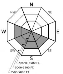
The snowpack is generally stable. The exception is steep sunny slopes where isolated areas of dry surface snow remain. Continued warming and sunshine may moisten this surface and result in loose slides. With the thin snow cover, even a small avalanche can have severe consequences. Areas sheltered from the sun and wind offer a safer and higher quality experience.

No Rating
?
Above 6500 ft.
No Rating
?
5000-6500 ft.
No Rating
?
3500-5000 ft.
-
Type ?
-
Aspect/Elevation ?

-
Size ?HistoricVery LargeLargeSmall

In areas where snow remains on trees or rocks, snow falling from these features will be an early clue to instability. On other slopes, indications may be rollerballs or the snow becoming sticky. As the high pressure intensifies, isolated pockets of dry snow may warm and weaken. Terrain capable of producing slides is steep, open to the sun, and at or above treeline. A safer, more enjoyable option is riding the dry low-density snow found in sheltered terrain. If you must cross on or below solar slopes, limit this to early morning or where a crust exists.
Sophia Sunshine is sitting in for old Man Winter this week. Strong high pressure began developing Tuesday, December 1, resulting in mountain air temperatures climbing to near or above freezing. Despite the sun’s low angle, solar input has melted snow up to 8500’ (Observation). Warming of dry surface snow on sunny aspects has produced the expected results, with loose snow slides reported from some of our area’s more impressive terrain (Observation, Observation). Many sunny slopes at or above treeline have transitioned to a moist snow surface with diminished loose slide potential. However, isolated areas harboring dry snow remain capable of loose slide activity. Thursday, most NW aspects on my tour held dry snow at mid and upper elevations. Do yourself a favor and skip the moist or crusty snow (Observation) and head for the north side of the compass, where you will find up to 9” of low-density surface snow and a deeper snowpack.
While traveling on north through east aspects at or above treeline, look for thin wind slabs. These have not shown signs of recent instability, but our observations are limited (Observation). It is good practice to identify and mitigate the hazards associated with this type of slab.
If you don’t park your vehicle in a garage, you have been scraping hoar frost from your windshield for the past few mornings. Something similar is occurring in the mountains, as surface hoar is developing on various aspects and elevations (Observation). This layer is pretty to look at and fun to slide through but may become a problematic weak layer when buried. Tracking where this layer is present or absent and then sharing your data with the FAC is a wonderful community service you can perform on your next outing. While you are at it, look for near-surface facets formed during this period of clear skies. Radiation recrystallization occurs on open sunny aspects at mid and upper elevations. Diurnal recrystallization forms “loud powder” in the dry low-density snow on the compass’s north side. Both of these are worth noting and can be weak reactive layers following a load.
FAC staff will begin daily forecasts on December 9. Your observations would be very helpful in the meantime. Stay in touch using our handy Snowpack Tracker.
Check out this winter's avalanche safety course schedule and sign up for a class that fits your needs.
A dominant ridge of high pressure continues to have a vice-like grip over our area. Valley floors will be stuck in a foggy, stratus soup while mountain locations above the cloud deck enjoy the sunshine and above-average temperatures. A change in this weather pattern may occur mid-week with the return of mountain snow.
This forecast applies only to backcountry areas outside established ski area boundaries. The forecast describes general avalanche conditions and local variations always occur. This forecast expires at midnight on the posted day unless otherwise noted. The information in this forecast is provided by the USDA Forest Service who is solely responsible for its content.


