| Tuesday | Tuesday Night | Wednesday | |
|---|---|---|---|
| Cloud Cover: | Mostly Clear | Mostly Clear | Mostly Clear |
| Temperatures: | 20 to 26 deg. F. | 12 to 16 deg. F. | 24 to 32 deg. F. |
| Wind Direction: | Northwest | North | Southwest |
| Wind Speed: | 11G23 | 9 | 7 |
| Snowfall: | 0" in. | 0" in. | 0" in. |
| Snow Line: | 1500' | 1500' | 3000' |
Whitefish Range
Swan Range
Flathead Range and Glacier National Park
How to read the forecast
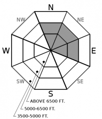
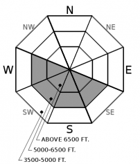
Avalanche conditions are generally safe. The exceptions are isolated thin slabs on north through east slopes at and above treeline. These will have a smoother and rounded appearance downwind of terrain features. Slopes sheltered from the wind offer soft snow and a safer option. More exceptions may occur on steep sunny slopes if prolonged sunshine develops. Move to shadier aspects, or lower slope angles, as the surface snow moistens.

No Rating
?
Above 6500 ft.
No Rating
?
5000-6500 ft.
No Rating
?
3500-5000 ft.
-
Type ?
-
Aspect/Elevation ?

-
Size ?HistoricVery LargeLargeSmall

Thin wind slabs formed below ridgelines and in cross-loaded gullies during the Thanksgiving holiday. They will appear pillowy and thicker than the surrounding snowpack. The steady wind has stiffened slabs and may not present signs of instability until you are on them. Early season surface hazards make even a small avalanche dangerous. You can find higher quality snow in sheltered locations.
-
Type ?
-
Aspect/Elevation ?

-
Likelihood ?CertainVery LikelyLikelyPossible
 Unlikely
 -
Size ?HistoricVery LargeLargeSmall

Rollerballs and snow melting from tree branches are precursors to loose slides. Up to 8" of dry low-density snow rests at the snow surface in sheltered locations. If forecasted warming and solar input materialize, this layer will weaken and result in loose snow sluffs. These will occur on steep sunny aspects at mid and upper elevations and may travel further than expected due to the underlying crust. Move to shadier slopes as the snow becomes moist.
Moisture ended Thanksgiving Day with modest snowfall (Observation, Observation ) and precipitation amounts. Since then, wind speeds have remained strong enough to transport low-density snow into thin slabs (Observation). However, snow available for transport has diminished daily, limiting new slab development but stiffening existing slabs. We have limited observations from alpine terrain (Observation), but we're assuming slabs are generally older and more stubborn to trigger. They may not present typical early warning signs of instability such as cracking or collapsing (whumphing) and lull you into a false sense of security. Slabs will be most dangerous where they rest on weak snow, surface hoar, or a slick crust. Identifying wind slabs on the slope, and steering around them, is a safe strategy and a great tool to have in your avalanche toolbox.
Loose snow avalanches may develop in the next few days courtesy of a strengthening inversion. A building ridge of high pressure is expected to increase mountain air temperatures and allow extended periods of sunshine through the week. Warming of cold, dry snow weakens bonds between the grains and may result in loose snow slides on steep southerly slopes. Your first clue might be the quality of the snow you're riding has deteriorated a bit. Your best bet is to move around the compass ahead of the sun or stick to the shady, sheltered aspects. This problem is relatively straightforward to identify and avoid.
The anticipated period of high pressure may also contribute to the development of faceted layers (Observation) at the base of our snowpack, around crusts, or just below the surface. Expect to find surface hoar (Observation) on a variety of aspects and elevations. Tracking where this layer develops will be beneficial to our forecasts when the snow returns.
Despite a mixed bag of early-season weather, we are wrapping up November with near to above-average snowpack at area Snotels between 4300 - 6300'. This percentage varies from 96% in the northern Whitefish Range, 114% in the Swan, 143% in the foothills above the Hungry Horse Reservoir, and 134% in GNP's interior.
FAC staff will continue to monitor conditions and post a snowpack update this Saturday, December 5. We anticipate daily forecasts to begin December 9. Your observations would be very helpful in the meantime. Stay in touch using our handy Snowpack Tracker.
Check out this winter's avalanche safety course schedule and sign up for a class that fits your needs.
A building ridge of high pressure will dominate our weather through the workweek. Mountain temperatures will steadily increase with extended periods of sunshine. Low clouds may develop, leading to dreary conditions and stagnant air quality on the valley floor
This forecast applies only to backcountry areas outside established ski area boundaries. The forecast describes general avalanche conditions and local variations always occur. This forecast expires at midnight on the posted day unless otherwise noted. The information in this forecast is provided by the USDA Forest Service who is solely responsible for its content.


