| Friday | Friday Night | Saturday | |
|---|---|---|---|
| Cloud Cover: | Mostly Cloudy | Mostly Cloudy | Mostly Cloudy |
| Temperatures: | 22 to 29 deg. F. | 19 to 23 deg. F. | 23 to 30 deg. F. |
| Wind Direction: | Southwest | Southwest | Southwest |
| Wind Speed: | 15G30 | 10G25 | 10G20 |
| Snowfall: | 1" to 3" in. | 0 to 1" in. | 0" in. |
| Snow Line: | 3000' | 3000' | 2500' |
Whitefish Range
Swan Range
Flathead Range and Glacier National Park
How to read the forecast
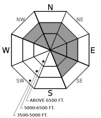
Recently formed slabs of new and drifted snow can have harsh consequences if they drag you into rocks, trees, stumps, or gullies. Be observant in your travels and watch for areas where wind transported new snow into slabs deeper than 8 inches. Shooting cracks and collapses are signs to seek terrain with slope angles less than 35 degrees.

No Rating
?
Above 6500 ft.
No Rating
?
5000-6500 ft.
No Rating
?
3500-5000 ft.
-
Type ?
-
Aspect/Elevation ?

-
Size ?HistoricVery LargeLargeSmall

Be wary of slopes that face North through East at mid and upper elevations. Recent snow and moderate to strong southwesterly wind drifted snow into slabs large enough to bury or injure you. Expect these slabs to be thickest and most dangerous near ridgelines and cross-loaded terrain features. Look for blowing snow and pillowy surface conditions as cues to seek wind-sheltered terrain. Give these areas a wide berth since even a small avalanche can drag you over trees, rocks, and stumps causing significant trauma.
Since Tuesday's update, warm temperatures and sunny skies have brought spring-like avalanche conditions. Observations came in describing the snowpack as "slop" and "isothermic," terms we typically see in March. This wave of warm weather did three things for the snowpack. On one hand, warm temperatures promoted rounding and settlement, making for dense, strong layers. On the other hand, it left us with a melt-freeze crust that makes a nice bed surface for new snow avalanche hazards.
Recent snow accumulations are difficult to map. The most favored areas seem to be around Marias Pass, where up to 8 inches of snow fell at remote weather stations. Stations in the Swan and the Whitefish Range appear to have picked up roughly a half-inch of water with little change in snow height. Two observations from Glacier National Park both found accumulations around 4 to 6 inches of new snow falling on the recently formed melt-freeze crust. One observer noted that the new snow was forming slabs up to 4 inches thick (observation 1, observation 2). Accompanying this precipitation were moderate winds that gusted to 60 mph out of the Southwest.
Warming, snowfall, and wind mean that the most significant avalanche hazard will be recently formed slabs of drifted snow. These will be most likely found on leeward aspects where 8 or more inches of snow fell. I expect this problem to be primarily located in the Flathead Range and Glacier National Park, though I wouldn’t be surprised if you can find this kind of accumulation at the upper elevations in the Swan or Whitefish Range.
At elevations where we have traveled and received observations (all below roughly 7200’), I have good confidence that you will be seeing primarily new snow hazards described above. The largest uncertainty is above this elevation where the snowpack is deeper and may have a weaker snowpack structure. The primary concern here is a crust/facet combination in the basal snowpack. This would result in a thicker, more dangerous avalanche if triggered. Give alpine start zones a wide berth if you feel whumpfing collapses or see recent avalanches.
FAC staff will continue to monitor conditions and post updates as conditions warrant. We anticipate daily forecasts and full operations to begin in December. Your observations would be very helpful in the meantime. Stay in touch using our handy Snowpack Tracker.
Check out this winter’s avalanche safety course schedule and sign up for a class that fits your needs.
Expect lingering snow showers to persist throughout the day and into Saturday evening. Snow accumulations are favoring the Whitefish Range, as well as the Flathead Range and Glacier National Park. High pressure sets into the region for the remainder of the weekend.
This forecast applies only to backcountry areas outside established ski area boundaries. The forecast describes general avalanche conditions and local variations always occur. This forecast expires at midnight on the posted day unless otherwise noted. The information in this forecast is provided by the USDA Forest Service who is solely responsible for its content.


