Avalanche Forecast published on November 14, 2020 @ 11:57 am
Issued by Blase Reardon - Flathead Avalanche Center

Whitefish Range
Swan Range
Flathead Range and Glacier National Park

How to read the forecast

With storms bringing new snow and strong winds to the region, be wary of slabs of new and drifted snow on steep slopes. These can have particularly harsh consequences if they drag you into rocks, trees, stumps, or gullies. The hazard is most widespread at upper elevations, where freshly-formed slabs may be sitting on hard, icy layers near the ground. Shooting cracks and collapses are warning signs of danger. Carry rescue gear and keep your partner in sight.

No Rating

?

Above 6500 ft.

No Rating

?

5000-6500 ft.

No Rating

?

3500-5000 ft.
Avalanche Problem 1: Storm Slab
  • Type ?
  • Aspect/Elevation ?
  • Size ?
    Historic
    Very Large
    Large
    Small

Recent storms and winds have deposited slabs of new and drifted snow 1 to 2 feet thick near ridgelines, in gullies, and behind prominent terrain features. Cracking in the surface snow or whumpfing collapses are signs that the slabs are sensitve to the weight of a rider or snowmachine, and that you can trigger slides on adjacent slopes. You can test for these slabs by punching your hand below the snow surface when you stop you snowmachine or by probing with a ski pole, being alert for hard-over-soft or dense-over-loose structures. Hidden obstacles can increase the consequences of getting caught in an early season slide, so look downslope for these obstacles before committing to steep terrain. 

Forecast discussion

Since Wednesday morning, 6-15" of new snow and 0.5-1.3" of SWE has accumulated at mountain weather stations. The series of storms looks to have favored the Whitefish and Flathead Ranges. The new snow is reported to be a little upside down (denser snow above lower-density snow). Some sites may also have picked up a thin ice crust near the surface, thanks to a brief freezing rain event Friday evening. Wind speeds were generally light to moderate during the snowfall, but have increased as the snowfall has tapered off. They've also veered more to west-northwest. 

After this combination of snowfall and wind, you can trigger slabs of new and drifted snow 1-2 feet thick on slopes steeper than about 35 degrees. These will break at density changes in the storm snow or where slabs of wind-stiffened snow are sitting on soft snow. Below about 6500 feet, there's few spots with older layers beneath the storm snow. Above that elevation, a very hard, icy layer of refrozen snow exists at the ground. This basal ice is, however, not continuously distributed below about 7500 feet, thanks to the warm winds and rain that preceded this week's snowfall. The top of that icy layer is also a potential failure plane for triggered slides, particularly if it harbors a thin layer of faceted snow.

The upshot is that assessing the hazard will be more straightforward at mid elevations, where drifts, dunes, and scoured patches can show where winds have created or removed slabs. At upper elevations, the spotty distribution of the basal melt-freeze layer makes things trickier. Because the snowpack is shallow, you can test for the presence of that layer by probing - ski pole or proble - before committing to steep slopes.  

With more light snow forecast for tonight and early in the week, expect these conditions to persist for a few days. A rapid warm up forecast for mid week will change things.

FAC staff will continue to monitor conditions and post updates as conditions warrant. We anticipate daily forecasts and full operations to begin in December. Your observations would be very helpful in the meantime. Stay in touch using our handy Snowpack Tracker.

We continue to get weather stations back up and running for the season. The Big Mountain station has not been recording accurate snow depths. Take it with a grain of salt.

Now is the time to tune up your avalanche knowledge. The last session of The 2020 Northern Rockies Snow and Avalanche Workshop is tonight (Saturday). You can still register!and buy raffle tickets 

Check out this winter’s avalanche safety course schedule and sign up for a class that fits your needs.


Weather and CURRENT CONDITIONS
weather summary

The mountains could wring a few inches of snow from low-level moisture each 12-hour period until Monday evening. Accompanying the light snow will be light to moderate, southwesterly windsl Temperatures will steadily warm before spiking on Tuesday. Another storm is forecast for Wednesday. 

Two-Day Mountain Weather Forecast Produced in partnership with the Missoula NWS
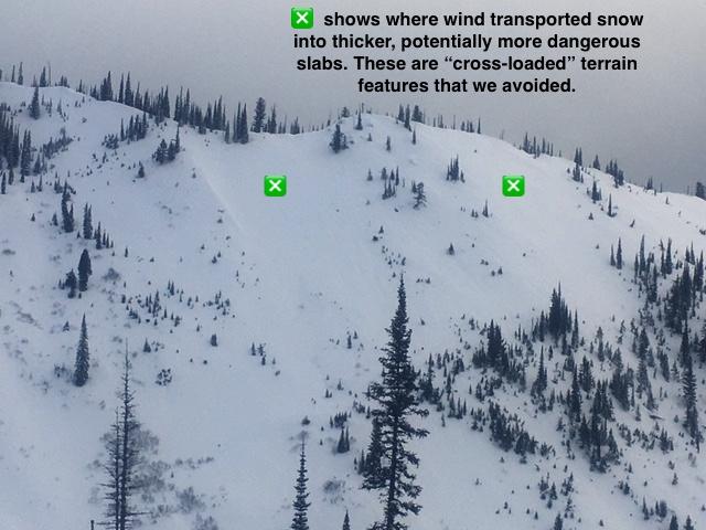
For 5000 ft. to 7000 ft.
Saturday Saturday Night Sunday
Cloud Cover: Mostly Cloudy Mostly Cloudy Mostly Cloudy
Temperatures: 16 to 26 deg. F. 15 to 20 deg. F. 28 to 33 deg. F.
Wind Direction: West Southwest Southwest
Wind Speed: 10 to 15, gusting to 40 10 to 15, gusting to 25 15 to 20, gusting to 30
Snowfall: T to 5" in. T to 4" in. 2" to 5" in.
Snow Line: 1500' 1000' 3500'
Disclaimer

This forecast applies only to backcountry areas outside established ski area boundaries. The forecast describes general avalanche conditions and local variations always occur. This forecast expires at midnight on the posted day unless otherwise noted. The information in this forecast is provided by the USDA Forest Service who is solely responsible for its content.