| Friday | Friday Night | Saturday | |
|---|---|---|---|
| Cloud Cover: | Mostly Cloudy | Mostly Cloudy | Partly Cloudy |
| Temperatures: | 15 to 22 deg. F. | -5 to 10 deg. F. | 5 to 15 deg. F. |
| Wind Direction: | Southeast | Northeast | Northeast |
| Wind Speed: | 5-10 G15 | 15-25 G45 | 15-25 G 40 |
| Snowfall: | 2" to 3" in. | 4-6" in. | 0" in. |
| Snow Line: | 1000' | 500' | 0' |
Whitefish Range
Swan Range
Flathead Range and Glacier National Park
How to read the forecast
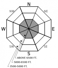
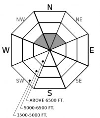
A winter snowpack exists at upper elevations, and this weekend's snow and wind will create more widespread avalanche hazards in this terrain. These are localized to steep slopes with with sufficient snow coverage to ski or ride. Carry rescue gear - beacon, shovel and probe. Look for the obvious clues of danger - recent avalanches, shooting cracks, and whumpfing collapses - if you're on or below steep terrain with continuous snow cover.

No Rating
?
Above 6500 ft.
No Rating
?
5000-6500 ft.
No Rating
?
3500-5000 ft.
-
Type ?
-
Aspect/Elevation ?

-
Size ?HistoricVery LargeLargeSmall

The ingredients for widespread drifting will be in place this weekend: low-density surface snow and a forecast for strong, easterly winds forecast Friday night. The drifting snow may collect into slabs sensitive to the weight of a rider or snowmachine on steep, upper-elevation slopes. These slabs can be dangerous where they're more than about six inches thick or triggered from below. They may feel hollow or crack around you. Look for them below ridges, in gullies, or behind other prominent terrain features. Because of the week's easterly winds, you may find these slabs in unusual spots. Thin snow cover means even small slides can have nasty consequences.
-
Type ?
-
Aspect/Elevation ?

-
Size ?HistoricVery LargeLargeSmall

On isolated, northerly slopes at high elevations, weak, faceted snow may exist below recent snow. This snow can collapse, triggering surprisingly wide slides despite the shallow snow cover. This hazard is localized to steep slopes with glaciers or other year-round snow cover, and shaded slopes where the ground surface is smooth grass or bedrock. Shooting cracks or whumpfing collapses are clear signs you've found these conditions. If you exerience these phenomena, retreat to lower-angled slopes with no steep slopes overhead.
Years ago, a Halloween reveler in Whitefish included a chainsaw in his costume. He'd start the saw at random moments, rev the throttle, and swing it around, terrifying people nearby who didn't know he'd taken the chain off the bar. You don't expect the real thing at a costume party.
The white in the mountains is no Halloween costume. At upper elevations, it's a winter snowpack with slabs and weak layers. Expect real avalanche hazards.
Over the past two weeks, snow, rain, wind, and cold temperatures have created a layered, winter snowpack at upper elevations. With a layered snowpack comes the potential for slab avalanches. This hazard is confined to steep slopes above about 6000 feet where the snowpack is deep enough to cover anchors. Visualize chutes or slopes near ridgelines where the surface is year-round snow or firn, low bushes and grass, or smooth, exposed bedrock. At lower elevations, the snow is shallow but the bush is deep.
So far, the upper-elevation snowpack is developing in ways that favor wind and storm snow avalanche problems. At all but the highest elevations, snow began accumulating less than two weeks ago, with only brief windows between storms. The snowpack generally consists of slabs of storm and drifted snow sitting above layers of softer snow or rain crusts. A mid-week storm favored opposite corners of the region (7"/0.5" SWE in the northern Whitefish Range and 7-11"/ 0.6-1" SWE near Marias Pass). More low-density snow is forecast for Friday afternoon and evening.
This week's cold, low-density snow was easily drifted by several bouts of wind. On Tuesday, riders reported small wind slabs existed on south and east slopes in the Lake McDonald area . Both the Hornet (Whitefish Range) and Aeneas Ridge (Swan Range) stations recorded strong northerly or easterly winds midweek, though these winds didn't appear at stations in the Flathead Range and Stevens Canyon. Another round of strong northerly and easterly winds is forecast for Friday night and is likely to result in widespread drifting at upper elevations.
The unseasonably cold temperatures could change trajectory of snowpack development. The weekend's Arctic temperatures will promote faceting in the relatively shallow snowpack, either in undisturbed, low-density snow near the snow surface or in moist snow near the ground. If the cold weather persists, these facets may develop into weak layers, creating the structure for Persistent Slab avalanche problems. In isolated spots, this hazard may already exist. Likely terrain includes high-elevation, shaded slopes with little ground cover for anchors.
Keep in mind that the shallow snow cover creates non-avalanche dangers, like hitting rocks, stumps, and logs. Hitting these while riding can have harsh, even tragic consequences. The same is true of getting caught in a slide.
FAC staff will monitor conditions through the fall and post updates as conditions warrant. We anticipate daily forecasts and full operations to begin in December. Your observations would be very helpful in the meantime.
Now is the time to tune up your avalanche knowledge. The 2020 Northern Rockies Snow and Avalanche Workshop will be held virtually from Nov. 12-14. The details are here and registration is open! Stay tuned for our upcoming avalanche class schedule later this fall.
We're working on getting the weather station at the summit of Whitefish Mountain Resort back online.
Moist Pacific air will overrun very cold Arctic air today, an unusual pattern for this time of year. The forecast region should see 4-8" of low-density snow this afternoon and evening, with higher amounts possible near the Continental Divide and in the southern Swan Range. Strong, easterly winds will follow the snowfall as the Arctic air pours over the Divide. The winds do not look to be confined to valley bottoms. Sunday will see cold but sunny conditions with light winds.
This forecast applies only to backcountry areas outside established ski area boundaries. The forecast describes general avalanche conditions and local variations always occur. This forecast expires at midnight on the posted day unless otherwise noted. The information in this forecast is provided by the USDA Forest Service who is solely responsible for its content.


