Avalanche Forecast published on April 21, 2020 @ 7:39 am
Issued by Blase Reardon - Flathead Avalanche Center

Whitefish Range
Swan Range
Flathead Range and Glacier National Park

How to read the forecast

Avalanche activity typically continues into summer in northwest Montana. Snow stability can deteriorate quickly with subtle changes in snow, rain, wind, sun, and temperatures. Until the snow melts, assess weather, snowpack, and terrain, and practice safe travel techniques that minimize your chances of triggering slides and the consequences of triggered and natural avalanches. Consider conditions on slopes above you while you’re traveling, as many Springtime avalanche concerns involve natural avalanches.

No Rating

?

Above 6500 ft.

No Rating

?

5000-6500 ft.

No Rating

?

3500-5000 ft.
Avalanche Problem 1: Loose Wet
  • Type ?
  • Aspect/Elevation ?
  • Size ?
    Historic
    Very Large
    Large
    Small

Loose wet avalanches are the most frequent avalanche problem in the spring. Unconsolidated new snow or saturated old snow sheds off steep terrain with rising temperatures, sun, or rain. These slides release from a single point but produce a surprisingly powerful amount of debris if they run long distances or entrain a lot of snow.  Rollerballs, pinwheels, or natural sluffs warn of decreasing stability. Move to colder snow or lower angled terrain when the snow becomes slushy or gloppy, and use extra caution below long, confined gullies.   

Avalanche Problem 2: Storm Slab
  • Type ?
  • Aspect/Elevation ?
  • Size ?
    Historic
    Very Large
    Large
    Small

Spring snowstorms often mean a return to winter-like conditions and a revival of wind slab, storm slab, and loose dry avalanche concerns. The danger these pose depends on the amount of new and drifted snow that accumulates, with more snow equaling larger, longer-running avalanches. Their sensitivity to human triggers tends to diminish after several days. During active weather, monitor storm totals, wind loading patterns, and bonding of the new snow to old snow surfaces, particularly melt-freeze crusts. Shooting cracks, more than a foot of new snow, or blowing snow are signs to stay off terrain steeper than 35 degrees. 

Avalanche Problem 3: Wet Slab
  • Type ?
  • Aspect/Elevation ?
  • Size ?
    Historic
    Very Large
    Large
    Small

Wet slab avalanches usually fail during prolonged or intense warmups, as meltwater pools and compromises the strength of deeply-buried weak layers. Your best defense is to travel early while the snowpack is frozen. If the snowpack doesn’t refreeze overnight, avoid steep terrain. Post-holing in wet snow is a sign you’re not welcome in avalanche terrain. Meltwater in the snowpack can also lubricate the ground, resulting in unpredictable catastrophic glide avalanches. Avoid traveling below slopes with glide cracks or large, overhanging cornices, especially during or shortly after warmups. These conditions can result in very destructive debris that runs across all elevation bands onto bare ground.  

Forecast discussion

Avalanche hazards linger until the snow is gone from the mountains, as demonstrated by a history of late-season accidents in the region. On May 27, 2019, natural wet snow avalanches (like those described above in the Wet Loose avalanche problem) stranded 13 cyclists on the Going-to-the Sun Road.  Earlier that spring, a skier was caught and carried in a soft slab that broke on a melt-freeze crust, a clear reminder of the Storm Slab avalanche problems that develop after springtime snowfall. Cornice fall caught a skier on Heavens Peak in Glacier National Park in May, 2018. 

These reports highlight the primary hazards of springtime travel in the mountains. Snow-covered slopes high above you can produce natural wet-snow avalanches that often reach well below snowline. Winter-like avalanche hazards can return when stormy weather hits the mountains. Cornices can break surprisingly far back, pulling people off a ridge and down a slope below. When and how you travel can reduce your exposure to these hazards. Start and end your day early, and limit your time below slopes with glide cracks or overhanging cornices, especially during or shortly after warmups. After recent snowfall, be alert for fresh avalanches, collapses, and cracks in the new snow, which are signals to avoid steep terrain. Stay well back from cornices on ridges.

This season, the transition away from winter has been slow. In the past few days, riders have reported natural avalanches involving recently drifted snow and a large avalanche that broke several feet deep on facets buried a month ago. At upper elevations, the snowpack continues to build, and layers of weak, faceted snow persist both in the the upper snowpack and near the ground. You can find the former just above crusts buried one to three feet deep. Several close calls involving these layers occurred in early April, and they do not yet seem to have gone dormant. An even larger concern are facets buried in November that produced very large and destructive avalanches in January and February. These layers may reactivate once meltwater percolating down from the surface reaches them, which may not occur until well into May. Extended periods of hot, sunny weather or rain on snow have the potential to produce catastrophic avalanches that involve the entire season's well-above average snowpack. 

The past week has also seen a round of wet snow avalanches at mid elevations and on steep, sun-exposed upper- elevation slopes. Most of these have been loose snow slides involving saturated surface snow. Some have gouged deep into the snowpack, pulling out snow near the ground. Some wet slabs have also run as meltwater reached near-surface weak layers. Wet snow avalanches will remain a hazard during periods of rain or when fresh snow heats up in sun and warm temperatures. Consecutive nights without a refreeze at higher elevations or recent wet slab activity mean it is time to take up a summer hobby until the snowpack refreezes again or transitions to a mature state. 

We've had reports of glide cracks starting to open in the Swan Range. No doubt they're opening elsewhere in the region as well. The slopes below these cracks can fail unpredictably, and the resulting slides can involve the entire season's snowpack. Don't dawdle below open glide cracks, even those well above you. This hazard can be particularly widespread on the slopes above the Going-to-the-Sun Road in Glacier National Park. 

This will be the last snowpack update for the season. We encourage you to continue to share and check observations, and use our weather stations map to follow conditions.  We will continue to update our social media with critical observations.  Thanks for a great winter and have a safe spring!   -Zach, blase, Clancy and Cam.

Video showing some of the avalanches that trapped cyclists on the Going-to-the-Sun road in May, 2019. 

A video report on an accident involving a skier and a storm slab avalanche in April, 2019. It's a good illustration of the hazards that stormy weather can create even when it's spring in the valleys.


Weather and CURRENT CONDITIONS
Two-Day Mountain Weather Forecast Produced in partnership with the Missoula NWS
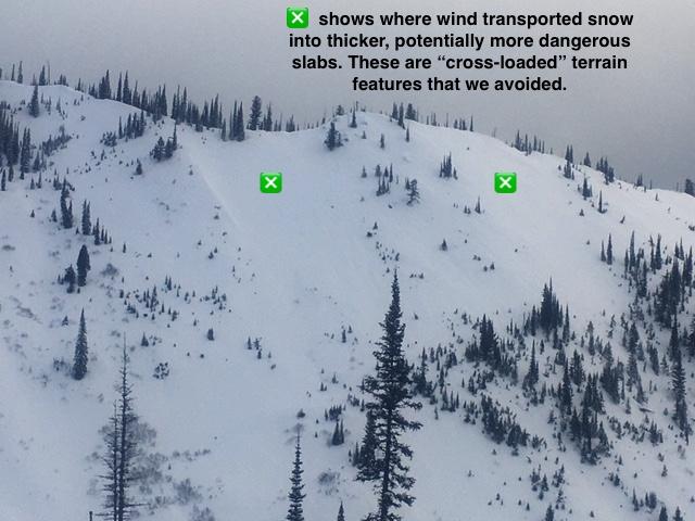
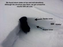
For 5000 ft. to 7000 ft.
Tuesday Tuesday Night Wednesday
Cloud Cover: Mostly Clear Mostly Cloudy Mostly Cloudy
Temperatures: 42 to 54 deg. F. 27 to 33 deg. F. 37 to 46 deg. F.
Wind Direction: Southwest West Southwest
Wind Speed: 14G25 14 15G25
Snowfall: 0" in. 0" in. 0" in.
Snow Line: 7000' 6500' 5500'
Disclaimer

This forecast applies only to backcountry areas outside established ski area boundaries. The forecast describes general avalanche conditions and local variations always occur. This forecast expires at midnight on the posted day unless otherwise noted. The information in this forecast is provided by the USDA Forest Service who is solely responsible for its content.