THIS AVALANCHE FORECAST EXPIRED ON April 18, 2020 @ 12:40 am
Avalanche Forecast published on April 17, 2020 @ 7:40 am
Issued by Zach Guy - Flathead Avalanche Center

Whitefish Range
Swan Range
Flathead Range and Glacier National Park

How to read the forecast

Instabilities this weekend will include solar-triggered wet loose slides on Friday and Sunday, and new or windblown snow that accumulates on Saturday.  Concerns for larger persistent slabs are becoming more isolated, but still exist.  

No Rating

?

Above 6500 ft.

No Rating

?

5000-6500 ft.

No Rating

?

3500-5000 ft.
Avalanche Problem 1: Loose Wet
  • Type ?
  • Aspect/Elevation ?
  • Size ?
    Historic
    Very Large
    Large
    Small

Expect new or recent snow to sluff as it becomes wet from sunshine and warming temperatures.  Observers on Thursday reported numerous fresh loose wet avalanches originating from steep terrain (Example A). Expect this trend to continue during Friday's and Sunday's sunny weather.  Solar induced wet instabilities generally start on the northeast quadrant of the compass in the morning, and shift through the south and then west as the day progresses.  Watch for rollerballs, pinwheels, and natural sluffs to warn you of changing conditions.  Move to colder snow or lower angle terrain to avoid the problem.  

Avalanche Problem 2: Wind Slab
  • Type ?
  • Aspect/Elevation ?
  • Size ?
    Historic
    Very Large
    Large
    Small

2" to 7" is forecast for Saturday, along with moderate winds that shift from the west to the east.  Watch for instabilities in the new and windblown snow by monitoring snowfall accumulations and noting where the winds are thickening and forming soft slabs.  Steer around slabs of wind drifted snow where the consequences of a slide could push you down a gulley, into trees, or over a cliff.  

Avalanche Problem 3: Persistent Slab
  • Type ?
  • Aspect/Elevation ?
  • Size ?
    Historic
    Very Large
    Large
    Small

On north-facing, high elevation terrain, persistent slabs breaking several feet thick remain a low likelihood and isolated concern.  A cornice-fall triggered persistent slab this week in the Flathead Range exemplifies the hazard.  Be wary of overhead hazards from cornice fall.   Be cautious on suspect aspects, particularly near unsupported rollovers or in terrain with rocky, variable snow coverage.  

Forecast discussion

Saturday's quick hitting storm will break the pattern of warm, sunny weather that started on Thursday.  Primary avalanche concerns will alternate between solar-triggered loose wet avalanches on Friday and Sunday, and new and wind blown instabilities on Saturday.

On Thursday, observers in the Swan and Flathead Ranges reported up to 6" of recent snow that sluffed easily under sunny weather, along with some cracking in wind drifted slopes.  In the Flathead Range, Mark also spotted a large persistent slab that was likely triggered by a cornice fall this week.  Friday looks to bring a similar weather pattern, and similar avalanche issues.  

A system on Friday night through Saturday will refresh the snow surface and refresh the avalanche problems.   Forecasts are calling for 2" to 7" by the end of the day on Saturday, favoring the Swan Range.  Winds start from the west but shift to the east/northeast early in the storm.  Watch for shallow storm instabilities to develop; most commonly wind slabs.  In areas that receive more than 6" of snow, be alert for storm slabs as well. 

Sunday will bring another round of sunshine and warming temperatures.  Wind slab instabilities that formed on Saturday will continue to pose a concern, but the more common problem will be loose wet sluffs caused by sunshine warming the new snow.   The size of instabilities on Saturday and Sunday will depend on how much new snow falls; expect larger and more widespread concerns in areas that receive more snow.  

This is our final off-season snowpack update for the spring.   We will issue a spring travel advisory on Monday that will serve the remainder of the season.  

Weather and CURRENT CONDITIONS
Two-Day Mountain Weather Forecast Produced in partnership with the Missoula NWS
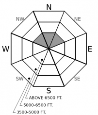
For 5000 ft. to 7000 ft.
Friday Friday Night Saturday
Cloud Cover: Partly Cloudy Mostly Cloudy Mostly Cloudy
Temperatures: 36 to 46 deg. F. 24 to 29 deg. F. 29 to 38 deg. F.
Wind Direction: West West Northeast
Wind Speed: 15G31 12G28 13G23
Snowfall: 0" in. 2" to 3" in. 2" to 3" in.
Snow Line: 4500' 5500' 4000'
Disclaimer

This forecast applies only to backcountry areas outside established ski area boundaries. The forecast describes general avalanche conditions and local variations always occur. This forecast expires at midnight on the posted day unless otherwise noted. The information in this forecast is provided by the USDA Forest Service who is solely responsible for its content.