Avalanche Forecast published on April 13, 2020 @ 1:55 pm
Issued by Blase Reardon - Flathead Avalanche Center

Whitefish Range
Swan Range
Flathead Range and Glacier National Park

How to read the forecast

A storm interrupts a week that starts cool and ends warm and sunny. Adapt to conditions of the day. New snow? Put your avalanche toque on and focus on wintertime avalanche hazards, like persistent slabs and new snow hazards. Sunny and warm? Lather up with sunscreen and wet-snow avalanche awareness. Details for the smorgasboard of hazards in the problem descriptions below. 

No Rating

?

Above 6500 ft.

No Rating

?

5000-6500 ft.

No Rating

?

3500-5000 ft.
Avalanche Problem 1: Persistent Slab
  • Type ?
  • Aspect/Elevation ?
  • Size ?
    Historic
    Very Large
    Large
    Small

Slopes that hold the most winter-like conditions are also the slopes most likely to harbor slabs 2-3 feet deep that sit on weak snow buried in late March. This structure produced a cycle of large, natural avalanches in the higher peaks of the region last week (Flathead Range, more Flathead Range, southern Swan Range). These slabs are gradually growing less sensitive to a person's weight, and the potential size of triggered slides is likely decreasing as well. Getting caught in one of these slides remains serious, however. Let this low likelihood / high consequences problem dictate your terrain choices. In the high, shady terrain where this problem is likely to persist, the least risky slopes are low-angle, planar, and free from rocks, trees, gullies, and cliffs. Lines that lack any of those characteristics increase your likelihood of triggering a slide, a well as the  potential consequences of triggered slides. Other triggers for these slides include falling cornices and smaller slides in the new snow, so it's worth staying out from under slopes likely to harbor this hazard.

Avalanche Problem 2: Loose Wet
  • Type ?
  • Aspect/Elevation ?
  • Size ?
    Historic
    Very Large
    Large
    Small

Start early, end early, and avoid being on or under steep slopes that receive sustained sun late in the day. Once the snow surface starts softening, make sure you have an exit strategy that allows you to escape to low angle or shady slopes before the snow near surface snowpack gets saturated. Slopes where fresh snow is getting wet for the first time are most likely to shed natural slides, so be alert for this hazard Wednesday and Thursday, if Tuesday night's storm delivers.

Avalanche Problem 3: Wind Slab
  • Type ?
  • Aspect/Elevation ?
  • Size ?
    Historic
    Very Large
    Large
    Small

Small slabs of drifted snow leftover from the past week pose an isolated hazard in steep, consequential terrain at upper elevations. If Tuesday night's storm delivers both new snow and northeasterly winds, a new crop of fresh slabs could form in the same terrain. The size will depend on the amount of new snow, with 6 to 8" of new snow and moderate winds likely to result in slabs large enough to bury or injure a person in terrain prone to collecting drifted snow. These spots include the tops of chutes and couloirs, the lee sides of gullies, and the downwind sides of ridges and saddles. With easterly winds, that's generally southwerly and westerly slopes, opposite of normal. These may be unusually sensitive to a person's weight when they're receiving direct sun. 

Forecast discussion

Sideswiped. Saturday's storm dove south, dropping 6-12" of snow in the Mission and southern Swan Ranges. Peaks just east of Marias Pass saw 6-8" while areas east and north only picked up a dusting. The new snow in the Missions sluffed easily (loose dry slides) before transitioning to wet loose slides as the day progressed. We had reports of small, isolated wind slabs at upper elevations from the Mission Range, the Middle Fork, and near near Marias Pass. Nobody reported venturing onto high, northerly slopes where the 3/24 facets and crusts are best preserved, so it's not clear if this structure is as sensitive to people as it was last week. 

A general outlook: Triggering avalanches that break on weak snow buried in March remains the primary concern. New snow hazards will develop for Wednesday, as a cold storm drops out of Canada. The extent and severity of these hazards depends on snowfall totals, which aren't clear yet. The hazard posed by wet snow avalanches will rise as warm weather and mostly clear skies arrive for the end of the week. Adapting to the conditions of the day will help you find the best riding with the least risky conditions. 

It is spring, so conditions can vary dramatically in short distances and over short intervals. And while cornice falls and glide slabs didn't make the problem list above, they can still pose immediate or site-specific hazards. Cornices tend to weaken and sag in sustained sunny weather, so look up at the terrain above you. Don't dawdle under ridges capped with cornices cantilevered into the air; the debris from falling cornices is remarkably dense and can travel surprisingly far. Similarly, avoid being under glide cracks - the brown frowns where the season's snowpack has slipped downslope at the ground. These too can fail randomly and produce long-running debris. 

Weather and CURRENT CONDITIONS
weather summary

Tonight the region will see cool temperatures and increasing clouds. Tuesday looks to have a brief push of warm air and broken skies before a cold, moist storm drops south from Canada. This system will bring snow and northeast and east winds Tuesday night, both favoring the Continental Divide and southern reaches of the region. The rest of the week sees a warming trend, with clearing skies.

Two-Day Mountain Weather Forecast Produced in partnership with the Missoula NWS
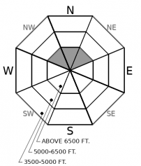
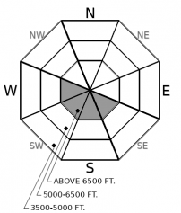
For 5000 ft. to 7000 ft.
Monday Monday Night Tuesday
Cloud Cover: Mostly Clear Mostly Cloudy Mostly Cloudy
Temperatures: 24 to 33 deg. F. 17 to 21 deg. F. 33 to 41 deg. F.
Wind Direction: Northwest West West
Wind Speed: 11G24 13G24 13G24
Snowfall: 0" in. 0" in. 0" in.
Snow Line: 500' 2000' 3000'
Disclaimer

This forecast applies only to backcountry areas outside established ski area boundaries. The forecast describes general avalanche conditions and local variations always occur. This forecast expires at midnight on the posted day unless otherwise noted. The information in this forecast is provided by the USDA Forest Service who is solely responsible for its content.