THIS AVALANCHE FORECAST EXPIRED ON April 10, 2020 @ 11:28 am
Avalanche Forecast published on April 6, 2020 @ 11:28 am
Issued by Blase Reardon - Flathead Avalanche Center

Whitefish Range
Swan Range
Flathead Range and Glacier National Park

How to read the forecast

The past week's run of remotely-triggered avalanches and near-misses highlights the complex conditions that exist on steep, shady slopes at upper-elevations. This hazard will linger through the week, while windy, warm and sunny weather also increases the likelihood of wet snow avalanche hazards at mid and low elevations and wind slabs near ridges and summits. Start and end your day early, minimize your time under steep start zones, and approach steep terrain cautiously. 

No Rating

?

Above 6500 ft.

No Rating

?

5000-6500 ft.

No Rating

?

3500-5000 ft.
Avalanche Problem 1: Persistent Slab
  • Type ?
  • Aspect/Elevation ?
  • Size ?
    Historic
    Very Large
    Large
    Small

The most reliable way to reduce your chances of triggering slides that break 2 to 3+ feet deep on old snow is by riding on slopes less than 30 degrees in steepness and stopping in spots that aren’t below steep start zones. If you choose steeper slopes, you can reduce your risk by riding in terrain that isn’t likely to harbor this hazard (the white quadrants in the aspect-elevation rose above), or with multiple, careful snowpack assessments. Keep in mind the past week’s string of remotely-triggered avalanches and near-misses, which highlight the complex and difficult-to-predict conditions left by a mid-March dry spell. Check out the discussion below for more details.

Avalanche Problem 2: Loose Wet
  • Type ?
  • Aspect/Elevation ?
  • Size ?
    Historic
    Very Large
    Large
    Small

The danger posed by wet snow avalanches will increase with the warm and sunny conditions forecast for the week. Recent snow that gets wet or saturated old snow can shed from steep terrain, often releasing from a single point but producing powerful amount of debris if they run long distances or gouge below the snow surface. Rollerballs, pinwheels, or natural sluffs warn of decreasing stability. Move to colder snow or lower angled terrain when the snow becomes slushy or gloppy, and use extra caution below long, confined gullies. Start your day early and have an exit strategy that avoids being on or under steep slopes where wet snow is likely.

Avalanche Problem 3: Wind Slab
  • Type ?
  • Aspect/Elevation ?
  • Size ?
    Historic
    Very Large
    Large
    Small

Gusty winds from multiple directions will drift snow at upper elevations, forming slabs 1 to 2 feet thick that can be triggered by a person's weight. Winds are forecast to be westerly and moderate to strong through Tuesday. Cold temperatures have kept the snow on windward aspects available for transport, so expect slabs to form at the tops of couloirs, on the lee sides of gullies, and below ridges and passes. Things get complicated Wednesday, when cold air east of the Divide could produce northerly or easterly winds at upper elevations. Though these winds should be lighter, they may build isolated small slabs on normally windward terrain and other unusual spots. Keep a sharp eye for dense snow that cracks around your machine or boards, and look for pillows, dunes, and drifts mid slope. 

Forecast discussion

FAC staff will issue the next snowpack update on Friday, April 10.

The one sentence version of the outlook: the persistent slab avalanche hazard will slowly diminish through the week, while the wet snow avalanche hazard will increase. 

Now for the details:

The past week’s run of remotely-triggered avalanches and near-misses (here and here) highlights the complex and unpredictable conditions created when storms buried facets and faceted crusts left by a mid-March dry spell. The storm snow has settled into slabs roughly 18 to 36 inches thick that sit atop the mid-March weaknesses. This structure has produced natural avalanches, slides that failed after multiple people crossed a slope, slides that wrapped across confining terrain features, and slides that released on lower-than-usual slope angles. Inconsistent feedback is complicating the problem, with no collapses or propagation in snowpit tests near slopes that subsequently released. The avalanche activity has been concentrated in the northeast quadrant of the compass above 5,800 feet. Nearly all reported slides have occurred in the Flathead Range, along with one natural avalanche reported from the southern Whitefish Range.  

With little additional loading, I expect the likelihood of triggering avalanches that break on the facets and faceted crusts to slowly diminish over the next few days. The unpredictability and spatial variability of the hazard will nonetheless prompt me to be very patient and mindful of slope angles and overhead start zones when traveling above about 5800 feet. Any terrain steeper than about 30 degrees will set off yellow caution lights in my head, and it should do the same for you. If you're tempted by steeper terrain, be aware that snowpack tests may not give an accurate sense of whether a collapse is likely to propagate across a slope. Tracks on a slope are definitely not a sign of stability in these conditions. Slopes with clean runouts diminish the consequences of misjudgements. The warm, sunny weather forecast for the middle of the weak will ultimately help heal this problem, though it may leave slabs more sensitive to a rider's weight on the warmest days as slabs consolidate rapidly.  

As the week progresses, managing the wet snow avalanche hazard will become increasingly important. Timing is one useful tool. Early starts after clear nights allow travel when the snow surface is most likely to be refrozen and meltwater production is minimal. Have an exit strategy that keeps you off of and out from under steep slopes recieving sustained sun, particularly those with rocks and cliffs that heat the snow sooner. The wet snow avalanche hazard will spike first on steep, mid-elevation terrain that faces the sun. Thursday's very warm temperatures may be enough to create wet snow on shaded, mid elevation slopes and isolated upper elevation slopes. 

Two avalanche fatalities in Wyoming this week highlight the winter-like and challenging avalanche conditions that are unusual at this time of year. Preliminary reports indcate that the victims in both accidents were wearing avalanche transceivers that were not turned on. Check your gear before leaving the trailhead. 

Weather and CURRENT CONDITIONS
weather summary

Weak flow from the northwest will bring cool, showery weather this afternoon and Tuesday. Cold air pushes east over the Divide Tuesday night. It's quickly pushed back by a warm, southwesterly flow Wednesday afternoon that last through the end of the week. Expect snow showers and gusty westerly winds today and Tuesday, with clouds breaking up Tuesday afternoon. Wednesday and Thursday look to be more springlike - warm and mostly sunny. Northwest flow returns Friday, bringing increasing clouds and snow showers. 

Two-Day Mountain Weather Forecast Produced in partnership with the Missoula NWS
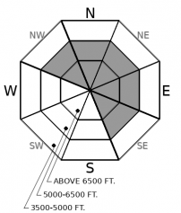
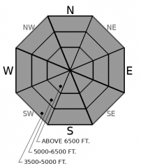
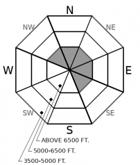
For 5000 ft. to 7000 ft.
Monday Monday Night Tuesday
Cloud Cover: Partly Cloudy Partly Cloudy Partly Cloudy
Temperatures: 30 to 39 deg. F. 23 to 27 deg. F. 32 to 40 deg. F.
Wind Direction: West Southwest West
Wind Speed: 14G25 16G29 18G36
Snowfall: 0 to 1" in. 0" in. 0" in.
Snow Line: 4000' 4500' 4000'
Disclaimer

This forecast applies only to backcountry areas outside established ski area boundaries. The forecast describes general avalanche conditions and local variations always occur. This forecast expires at midnight on the posted day unless otherwise noted. The information in this forecast is provided by the USDA Forest Service who is solely responsible for its content.