| Thursday | Thursday Night | Friday | |
|---|---|---|---|
| Cloud Cover: | Mostly Cloudy | Mostly Cloudy | Mostly Cloudy |
| Temperatures: | 18 to 26 deg. F. | 7 to 12 deg. F. | 23 to 30 deg. F. |
| Wind Direction: | South | Southwest | Southwest |
| Wind Speed: | 5 to 10, gusting to 15 | 5 to 10, gusting to 15 | 10 to 15, gusting to 25 |
| Snowfall: | 0 to 1" in. | 0" in. | 1 to 2" in. |
| Snow Line: | 500' | 1500' | 1500' |
Flathead Range and Glacier National Park
How to read the forecast
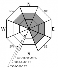
Everybody out of the pool. The deep end, at least. Complex and unpredictable conditions have curtailed the terrain where you can ride with confidence that slopes won't slide. The culprit is a weak layer buried 1 to 3 feet deep that produced a large, remotely-triggered avalanche in the northern Flathead Range Wednesday. Fortunately, cold weather is preserving good riding conditions on moderately-angled sunny slopes. Stick to these and avoid riding on or under steep, shady slopes.

2. Moderate
?
Above 6500 ft.
2. Moderate
?
5000-6500 ft.
1. Low
?
3500-5000 ft.
- 1. Low
- 2. Moderate
- 3. Considerable
- 4. High
- 5. Extreme
-
Type ?
-
Aspect/Elevation ?

-
Likelihood ?CertainVery LikelyLikelyPossible
 Unlikely
 -
Size ?HistoricVery LargeLargeSmall

You can trigger dangerous avalanches that break 1 to 3 feet deep on slopes steeper than about 30 degrees. It's possible to trigger these slabs from below or from adjacent slopes. Stay off and out from under any slope steep enough to slide that's above about 5500 feet and facing northwest through northeast to southeast. Snowpack tests and test slopes are not producing consistent feedback, and you may not see signs of instability before a slope fails. The potential size of triggered slides, uncertainty about the distribution of the weak layer, and unpredictability all demand a conservative approach today. Heed warning signs like shooting cracks, whumpfing collapses, and recent avalanches.
-
Type ?
-
Aspect/Elevation ?

-
Likelihood ?CertainVery LikelyLikelyPossible
 Unlikely
 -
Size ?HistoricVery LargeLargeSmall

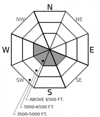
Northerly and easterly winds have been drifting snow into slabs that can break 1 to 2 feet deep under the weight of a snowmachine or person. Expect to find these in unusual spots, such as short convex rolls well below ridges. Cracking in dense snow is a clear sign that you've found this problem. Small slabs can have big consequences if they carry you into or over terrain that makes deep burials or trauma more likely.
The avalanche danger rating has diminished since Tuesday's storm, though the chances of an avalanche accident may be rising. That's because of an abrupt and unwelcome development in the near surface layers of the snowpack. Recent and drifted snow have buried a weak layer formed during the stretch of fair weather in mid March, when benign conditions put even very consequential slopes on run lists. Collapses on this weak layer - small near-surface facets, sometimes near a fragile crust - can propagate widely across start zones and adjacent terrain, producing large, dangerous avalanches. So after a long stretch of Low to Moderate danger, the party's over, at least for a little while. A defensive, conservative mindset is critical for the moment, on both ascents and descents.
To be clear, I'm basing the above on limited though very clear evidence. Tuesday, two forecaster teams in the Middle Fork reported propagating results on facets buried 3/24, the first propagating results in while. Wednesday, a forecaster team remotely triggered a large (R3 D2.5) avalanche in very consequential terrain. Zach's video below describes the event. One notable feature of the slide was the relatively low slope angle in much of the start zone - 33 degrees. Only one slide, sure. But it was the only slope they tested. And several other large slides had run on adjacent slopes. Those are the first slides breaking on buried weak layers reported in weeks, even with riders testing very steep slopes at all elevations during that time. It's like a lightning strike near the neighborhood pool. Everybody out until the storm passes, at least in the Flathead Range. That may not be long, if the 3/24 weak layer proves to be more isolated than the evidence of the past few days suggests.
In the other ranges, it's not clear yet how extensive this problem is. Yesterday's three reports from near Whitefish Mountain Resort describe isolated slabs of drifted snow and long-running sluffs as the primary hazards. Storm totals in the northern Whitefish Range were impressive - over 2 inches of Snow Water Equivalent - accompanied by gusty northerly and easterly winds. The Swan Range may, for once, have wrung less snow out of the storm than other ranges, but the Aeneas weather station shows powerful and sustained winds from both west and east at different stages of the storm. In these ranges, storm snow avalanche problems may remain the most widespread hazards. But I'll still be avoiding consequential avalanche terrain until I got more consistent evidence that the 3/24 facet/ facet crust layer didn't exist or wasn't reactive. Profiles and snowpack tests are the safest way to get that information right now.
Cold air infiltrating from Canada holds on today, though with some breaks in the clouds, it will be a few degrees warmer. Winds will be light with some moderate gusts, veering from SE to W early afternoon. While snow showers are possible, little snow will accumulate. A weak system Friday may bring a few inches of new snow and milder temperatures.
This forecast applies only to backcountry areas outside established ski area boundaries. The forecast describes general avalanche conditions and local variations always occur. This forecast expires at midnight on the posted day unless otherwise noted. The information in this forecast is provided by the USDA Forest Service who is solely responsible for its content.


