| Tuesday | Tuesday Night | Wednesday | |
|---|---|---|---|
| Cloud Cover: | Mostly Cloudy | Mostly Cloudy | Mostly Cloudy |
| Temperatures: | 24 to 32 deg. F. | 5 to 10 deg. F. | 16 to 25 deg. F. |
| Wind Direction: | Southwest | Northeast | Northeast |
| Wind Speed: | 16G37 | 18G32 | 17G33 |
| Snowfall: | 3" to 6" in. | 3" to 4" in. | 1" in. |
| Snow Line: | 2500' | 500' | 0' |
Whitefish Range
Swan Range
Flathead Range and Glacier National Park
How to read the forecast
On steep slopes, you can trigger avalanches of new and drifted snow that break one to two feet deep. Stay on the lookout for shooting cracks, whumpfing collapses, and recent avalanches. Stick to lower angled, sheltered slopes to minimize your exposure to these hazards. If snow accumulations exceed forecasts, the danger may spike to Considerable later this afternoon.

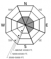
2. Moderate
?
Above 6500 ft.
2. Moderate
?
5000-6500 ft.
1. Low
?
3500-5000 ft.
- 1. Low
- 2. Moderate
- 3. Considerable
- 4. High
- 5. Extreme
-
Type ?
-
Aspect/Elevation ?

-
Likelihood ?CertainVery LikelyLikelyPossible
 Unlikely
 -
Size ?HistoricVery LargeLargeSmall

Strong southwesterly winds have deposited dense slabs of drifted snow below cornices, at the tops of chutes, and on the lee sides of gullies. These slabs have been building for several days. They are larger at upper elevations, where more snow was available for transport. Be alert for isolated examples at mid elevations, including runs at ski areas that aren't operating. These slabs may hard, more easily triggered from their edges, and break above you.
-
Type ?
-
Aspect/Elevation ?

-
Likelihood ?CertainVery LikelyLikelyPossible
 Unlikely
 -
Size ?HistoricVery LargeLargeSmall

On steep slopes sheltered from the wind, you can trigger soft slabs of new and recent snow that break 6 to 15 inches deep. These slabs will be thicker and more widespread at upper elevations. They will grow larger and more sensitive to a person's weight as snowfall accumulates today. Choose more conservative terrain if you see heavy snowfall rates or more than 6" of new snow today. Sticking to slopes less than about 30 degrees is a straightforward way to enjoy the new snow.
Despite yesterday's soggy valley weather, strong winds and new snow combined to create winter-like avalanche hazards at mid and upper elevations. The danger posed by these hazards peaked late yesterday as a cold front swept across the region. It left behind slabs of drifted and recent snow that continue to pose a danger on steep slopes today. Snow showers this afternoon may bring bursts of heavy snow, gusty winds, and increasing danger. Reset your mind to "Winter" and actively look for signs of new snow instabilities, like recent slides, shooting cracks, and whumpfing collapses. Or, stick to sheltered slopes less than about 35 degrees, where you can find good riding with fewer slabs.
There's some uncertainty about today's snowfall. If the storm track shifts slightly north, we could see higher accumulations of up to 8 inches by sunset. The convective nature of today's precipitation is adding to that uncertainty. Spots under convective cells could see brief periods with high snowfall rates and gusty winds. Be prepared for variable and changing conditions, and dial it back if you see more than about 6 inches of new snow today.
The line between winter and spring is somewhere between 5500 and 6000 feet. Above that elevation, a foot or more of recent snow has fallen in the past few days, and strong winds have drifted some snow into dense slabs one to two feet thick. Active tests can provide reliable information about the size and sensitivity of these Storm and Wind Slabs. Stomping above a skin track or at switchbacks can give you a sense of how cohesive and thick a slab is, as can hand pits. Probing with a pole can tell you whether slabs are similar thickness across a slope. On a snowmachine, cutting above another rider's tracks can give you similar information. Slope cuts on terrain with runouts clear of trees, gullies, and rockbands can provide good feedback about how sensitive a slab is to a rider's weight.
Below about 5500 feet, rain and warm temperatures have left the surface layers of the snowpack wet. This snow is gradually refreezing as temperatures cool. Without additional water input, you're unlikely to trigger wet snow avalanches. Glide slabs, however, can release more randomly, so stay out from under these brown frowns.
Winter holds on up high today, with snow showers increasing through the day and into tonight. Expect 2 to 4 inches of new snow across most of the region, with about the same tonight. Convective lifting may create some showers with more intense winds and snowfall rates. Arctic air drains over the Continental Divide early tomorrow morning, bringing single digit temps to upper elevations and easterly winds. No, not an April Fools prank.
This forecast applies only to backcountry areas outside established ski area boundaries. The forecast describes general avalanche conditions and local variations always occur. This forecast expires at midnight on the posted day unless otherwise noted. The information in this forecast is provided by the USDA Forest Service who is solely responsible for its content.


