| Monday | Monday Night | Tuesday | |
|---|---|---|---|
| Cloud Cover: | Mostly Cloudy | Overcast | Mostly Cloudy |
| Temperatures: | 30 to 38 deg. F. | 18 to 22 deg. F. | 25 to 33 deg. F. |
| Wind Direction: | Southwest | Southwest | Southwest |
| Wind Speed: | 10 to 20, G40 | 10 to 20, G40 | 10 to 20, G40 |
| Snowfall: | 2" to 6" in. | 3" to 7" in. | 3" to 6" in. |
| Snow Line: | 5500' | 3000' | 2500' |
Whitefish Range
Swan Range
Flathead Range and Glacier National Park
How to read the forecast
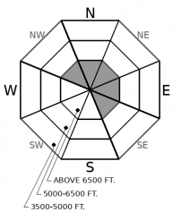
Wind loading continues up high, and wet avalanche hazards will redevelop below today's rain line. The danger is MODERATE through the day but will rise towards CONSIDERABLE this evening as a hard-hitting snow storm arrives. Pay attention to changing conditions this afternoon.

2. Moderate
?
Above 6500 ft.
2. Moderate
?
5000-6500 ft.
1. Low
?
3500-5000 ft.
- 1. Low
- 2. Moderate
- 3. Considerable
- 4. High
- 5. Extreme
-
Type ?
-
Aspect/Elevation ?

-
Likelihood ?CertainVery LikelyLikelyPossible
 Unlikely
 -
Size ?HistoricVery LargeLargeSmall

Stay off of steep, windloaded terrain features at upper elevations to avoid triggering a slab of drifted snow. With transportable snow at upper elevations, sustained southwest winds continue to thicken or build fresh wind slabs. Over the past two days, observers have reported blowing snow, shooting cracks, and triggered slides in leeward terrain. Some recently-formed slabs will be large and stubborn, while others will be small and easy to trigger. You can avoid all of them by seeking out wind-sheltered terrain away from blowing snow. Shooting cracks and collapses are obvious signs of instability.
-
Type ?
-
Aspect/Elevation ?

-
Likelihood ?CertainVery LikelyLikelyPossible
 Unlikely
 -
Size ?HistoricVery LargeLargeSmall

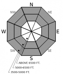
The rain line is expected to rise to around 5500' this afternoon. Where the snow surface becomes gloppy or mushy, expect to trigger loose wet slides in steep terrain. Several loose wet sluffs were triggered or ran naturally yesterday. These slides can pack a surprisingly heavy punch or grow to large sizes if they funnel down long, steep gullies. Move towards less consequential terrain if you observe the snow surface producing pinwheels, rollerballs, or sluffs under your feet or snowmachine.
Another warm, wet, windy day. Lather, rinse, and repeat in the Pacific Shower. But don't get complacent, because conditions will change this evening.
The past few days have brought high snow levels, with upwards of a foot of snow accumulating at high elevations, and a wintery mix of moist snow and rain at mid and low elevations. Where the snow is dry and blowing around in the wind, observers have triggered wind slabs, seen shooting cracks, and produced collapses in wind drifted terrain. Where the snow is wet and gloppy, observers have triggered loose wet slides (Example A, Example B). This pattern continues today, although I expect both problems to be a little quieter without the inputs of new snow or rain last night.
Instabilities will reinvigorate this afternoon with the arrival of more precipitation and a cold front. New and windblown snow will develop a fresh round of reactive storm hazards. Paired with decreasing temperatures, newly-developed slabs will expand down to mid-elevations. The danger will rise towards CONSIDERABLE. I expect the bulk of this action to occur after 6 p.m., so today's forecasted danger rating and problems focus on what we expect to see during the daylight hours. Pay attention to changing conditions if you are out after your Zoom happy hour is supposed to start.
Precipitation has eased off overnight into this morning, while southwest winds continue to gust beyond 30 mph at high elevations. Precipitation will increase this afternoon ahead of a cold front. Snow levels will initially start around 5,500', but drop through the evening. Favored areas could see up to a foot of new snow at high elevations by tomorrow afternoon.
This forecast applies only to backcountry areas outside established ski area boundaries. The forecast describes general avalanche conditions and local variations always occur. This forecast expires at midnight on the posted day unless otherwise noted. The information in this forecast is provided by the USDA Forest Service who is solely responsible for its content.


