THIS AVALANCHE FORECAST EXPIRED ON March 29, 2020 @ 11:30 pm
Avalanche Forecast published on March 29, 2020 @ 6:30 am
Issued by Zach Guy - Flathead Avalanche Center

Whitefish Range
Swan Range
Flathead Range and Glacier National Park

How to read the forecast

A handful of natural and triggered wind slabs ran yesterday.  Continued snow and winds last night will keep the hazard elevated on higher elevation, wind loaded terrain.  Watch for wet sluffs where the snow is gloppy and pinwheeling.  

2. Moderate

?

Above 6500 ft.
Heightened avalanche conditions on specific terrain features. Evaluate snow and terrain carefully; identify features of concern.

2. Moderate

?

5000-6500 ft.
Heightened avalanche conditions on specific terrain features. Evaluate snow and terrain carefully; identify features of concern.

1. Low

?

3500-5000 ft.
Generally safe avalanche conditions. Watch for unstable snow on isolated terrain features.
    Heightened avalanche conditions on specific terrain features. Evaluate snow and terrain carefully; identify features of concern.
  • 1. Low
  • 2. Moderate
  • 3. Considerable
  • 4. High
  • 5. Extreme
Avalanche Problem 1: Wind Slab
  • Type ?
  • Aspect/Elevation ?
  • Likelihood ?
    Certain
    Very Likely
    Likely
    Possible
    Unlikely
  • Size ?
    Historic
    Very Large
    Large
    Small

Seek out wind sheltered or wind-scoured terrain to avoid today's wind slab problem. Observers yesterday triggered wind slabs up to 12" thick on drifted rollovers, cross-loaded gullies, and below leeward ridgelines.  Steady southwest winds continue to thicken wind drifted slabs at upper elevations and in isolated areas at mid-elevations.   Step back from steep terrain where the snow is blowing into thick, dense drifts.  Shooting cracks and collapses are obvious signs of instability.  

Avalanche Problem 2: Loose Wet
  • Type ?
  • Aspect/Elevation ?
  • Likelihood ?
    Certain
    Very Likely
    Likely
    Possible
    Unlikely
  • Size ?
    Historic
    Very Large
    Large
    Small

The rain line is expected to rise to around 5500' or 6,000' today.  Where the recent snow becomes wet from warming temperatures or rain on snow, this can produce shallow sluffs in steep terrain.  Loose wet sluffs can pack a surprisingly heavy punch: you don't want to get knocked over by one above a terrain trap.  Watch out for natural sluffs dumping out of steep chutes above you.   Monitor the snow surface to identify changing stability - rollerballs and pinwheels are clear precursors to loose wet avalanches.  

Forecast discussion

Mountain stations are showing up to 0.7” of Snow Water Equivalent that fell since yesterday’s report, favoring Stahl Peak (Northern Whitefish) and Flattop (Glacier Park) SNOTELS.  Precipitation came in warm, with temperatures in the low 30’s.   This likely translates to rain at low elevations, a few inches of dense, moist snow at mid elevations, and deeper storm totals approaching 6” or more at upper elevations. This is similar in fashion to Friday night’s system, which favored the Swan.  Transportable wind speeds continue in the alpine, where stations are showing moderate to strong southwest winds. 

As you climb higher in elevation, storm accumulations are deeper and drier, which means there is more snow available for winds to work with.  Observers yesterday noted easily triggered wind slabs, shooting cracks, and collapses on wind loaded terrain features.  Wind slabs failed on sun crusts, low density snow, and faceted snow that was buried earlier in the week.  With continued snowfall and winds up high, expect these wind slabs to thicken and fresh wind slabs to develop.

Temperatures are on an upward trend in the last few days, with stations at 6,000' already hovering near freezing early this morning.  As the rain line rises through mid-elevations today, recent snow that moistens or becomes wet will be conducive for human triggered or natural loose wet sluffs.  Use caution near terrain traps as you transition through the elevation band with sticky, gloppy snow, highlighted by rollerballs and pinwheels.  I expect this will be somewhere around 5,500’, give or take.    

COVID-19 Updates:

The Montana Governor's Stay at Home Directive is in effect. The order allows for outdoor activities to continue (as long as you keep the mandated 6 feet of social distancing). However, "Montanans are discouraged from outdoor recreation activities that pose enhanced risks of injury or could otherwise stress the ability of local first responders to address the COVID-19 emergency (e.g., backcountry skiing in a manner inconsistent with avalanche recommendations or in closed terrain)."   Dial it back during these unusual times.

Glacier National Park has temporarily closed to visitors. The Flathead Avalanche Center will suspend fieldwork and forecasting for areas within Glacier National Park's boundaries. This includes the Apgar Range, the Lake McDonald area, and John F Stevens Canyon area north of Highway 2. The polygons on our forecast region map do not reflect these changes. The Flathead National Forest remains open to public use and the FAC will continue daily operations for the Whitefish, Swan, and Flathead Ranges under current guidance.


Weather and CURRENT CONDITIONS
weather summary

Southwest flow is streaming warm, moist Pacific air across the region today and tomorrow, bringing mild temperatures, a mix of snow and rain to the mountains, and steady southwest winds.  The polar jet sags over the Pacific Northwest on Monday night, bringing a cooler air mass over the region for the work week.  Monday evening’s cold front should intensify snowfall rates sometime late in the day.     

Two-Day Mountain Weather Forecast Produced in partnership with the Missoula NWS
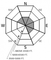
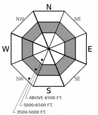
For 5000 ft. to 7000 ft.
Sunday Sunday Night Monday
Cloud Cover: Overcast Overcast Overcast
Temperatures: 34 to 39 deg. F. 24 to 29 deg. F. 32 to 37 deg. F.
Wind Direction: Southwest Southwest South
Wind Speed: 10 to 15, G30 10 to 15, G30 10 to 20, G35
Snowfall: 1" to 3" in. 2" to 3" in. 4" in.
Snow Line: 5500' 4500' 5000'
Disclaimer

This forecast applies only to backcountry areas outside established ski area boundaries. The forecast describes general avalanche conditions and local variations always occur. This forecast expires at midnight on the posted day unless otherwise noted. The information in this forecast is provided by the USDA Forest Service who is solely responsible for its content.