| Friday | Friday Night | Saturday | |
|---|---|---|---|
| Cloud Cover: | Mostly Cloudy | Mostly Cloudy | Mostly Cloudy |
| Temperatures: | 26 to 34 deg. F. | 22 to 27 deg. F. | 30 to 37 deg. F. |
| Wind Direction: | Southwest | Southwest | Southwest |
| Wind Speed: | 10G25 | 16G28 | 15G28 |
| Snowfall: | 1 to 3"" in. | 1" to 4" in. | 0" in. |
| Snow Line: | 3000' | 4000' | 4000' |
Whitefish Range
Swan Range
Flathead Range and Glacier National Park
How to read the forecast
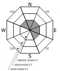
Enjoy mostly stable avalanche conditions today. Steer around recently formed wind slabs below leeward ridgelines. If we receive more snow than forecast, expect to see small loose dry sluffs in wind-protected areas. Though I expect both of these problems not to be large enough to bury you, they can be consequential if they knock you off your feet above a terrain trap.

1. Low
?
Above 6500 ft.
1. Low
?
5000-6500 ft.
1. Low
?
3500-5000 ft.
- 1. Low
- 2. Moderate
- 3. Considerable
- 4. High
- 5. Extreme
-
Type ?
-
Aspect/Elevation ?

-
Likelihood ?CertainVery LikelyLikelyPossible
 Unlikely
 -
Size ?HistoricVery LargeLargeSmall

Limited observations yesterday reported isolated slabs of wind drifted snow. Today you can find small slabs on leeward slopes below ridgelines and cross-loaded terrain features like gullies and sub ridges further downslope. They will likely be stubborn today and not large enough to bury you, but can be consequential if they drag you into a terrain trap. Look and feel for cracking in denser snow, and be cautious of hollow drifts. These are clues to seek wind-sheltered terrain.
Yesterday we received reports of generally stable avalanche conditions. Riders were able to trigger sluffs in wind protected areas, and small wind slabs just below ridgelines and cornices. Below roughly 5000 feet observations were unanimous, moist surfaces and fields of rollerballs. Expect to see similar conditions today with a good refreeze overnight and light snowfall.
Looking at remote weather stations, winds were at steady speeds of 15 to 20 mph with gusts up to 45 mph yesterday. Ideal speeds to form wind slabs, right? The answer is yes. However, the key ingredient is having snow available to transport. Recent, showery weather left us with trace amounts of snow in some locations and up to 6 inches of snow in others. So you'll have to assess for wind slab hazards “on the fly” because snow depths will vary from basin to basin and region to region. Look for dune shaped pillows and wind-scoured surfaces as clues of previous wind transport. Shooting cracks and hollow feeling drifts are signs that you're better off seeking wind sheltered terrain.
Forecast new snow amounts have trended lower over the past 24 hours. Models are showing fair confidence in a trace to three inches of snow. The Swan Range is favored. This will help refresh surfaces and increase the quality of riding without adding much of a hazard. If we do end up seeing more snow than forecast, which is possible, be mindful of loose dry avalanche hazards. These will be most common in terrain steeper than 40 degrees and under rocky cliff bands. Don't get taken out by your sluff and mind overhead hazards where snow can funnel down and knock you off your feet.
We encourage you to re-evaluate your level of acceptable risk. Our healthcare system could become increasingly overtaxed. Any backcountry accidents could put extra strain on already stressed emergency medical services. Please take care of yourself.
Snow showers will pick up throughout the day resulting in a trace to three inches of snow. Winds will be light gusting to moderate out of the southwest. The freezing line will hover around 5000 feet.
This forecast applies only to backcountry areas outside established ski area boundaries. The forecast describes general avalanche conditions and local variations always occur. This forecast expires at midnight on the posted day unless otherwise noted. The information in this forecast is provided by the USDA Forest Service who is solely responsible for its content.


