| Thursday | Thursday Night | Friday | |
|---|---|---|---|
| Cloud Cover: | Increasing Clouds | Mostly Cloudy | Mostly Cloudy |
| Temperatures: | 25 to 33 deg. F. | 18 to 23 deg. F. | 26 to 34 deg. F. |
| Wind Direction: | West | Southwest | Southwest |
| Wind Speed: | 15G31 | 15G31 | 14G29 |
| Snowfall: | 0" in. | 0 to 1" in. | 2" to 8" in. |
| Snow Line: | 1500' | 2500' | 2500' |
Whitefish Range
Swan Range
Flathead Range and Glacier National Park
How to read the forecast
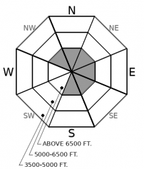
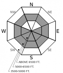
Fresh wind slabs will likely develop in leeward, alpine terrain. Loose wet avalanches are possible on very steep slopes where the surface thaws by this afternoon. Triggering avalanches is more likely where the most new snow fell yesterday. Watch for blowing snow up high and rollerballs down low as signs of increasing instability.

2. Moderate
?
Above 6500 ft.
1. Low
?
5000-6500 ft.
1. Low
?
3500-5000 ft.
- 1. Low
- 2. Moderate
- 3. Considerable
- 4. High
- 5. Extreme
-
Type ?
-
Aspect/Elevation ?

-
Likelihood ?CertainVery LikelyLikelyPossible
 Unlikely
 -
Size ?HistoricVery LargeLargeSmall

Increased winds and isolated showers will build fresh wind slabs on northwest through south aspects. Watch for blowing snow on the leeward side of alpine ridges and on the sidewalls of steep chutes. Recent drifts will be denser and may have a rippled texture. Older, potentially larger, drifts may be camouflaged by newer snow. Steer clear of rounded dunes in likely, down-wind areas. Even small wind slabs can be dangerous in consequential terrain. Continue to give cornices, and the slopes below them, due caution.
-
Type ?
-
Aspect/Elevation ?

-
Likelihood ?CertainVery LikelyLikelyPossible
 Unlikely
 -
Size ?HistoricVery LargeLargeSmall

Surface snow will thaw on all aspects if temperatures climb above freezing before the clouds come in today. Rollerballs are a warning sign that loose wet avalanches may be possible. Steep rocky gullies and vegetated areas will warm first and most. Avalanches will be more likely where loose snow is getting wet for the first time. If the weather forecast verifies, that will be middle elevations and on northerly aspects. Slides will be larger where there is more loose snow getting wet. You can avoid the problem by riding lower angled terrain as the surface thaws. You can limit the consequences by avoiding slopes with terrain traps below.
Spotty, brief, but heavy showers yesterday dropped a few inches of new snow here and there. Observers across the Flathead Range reported everything from blue skies to whiteout conditions, and between trace and 2 inches of snow by the afternoon. The Noisy Basin SNOTEL recorded the most new snowfall with 4 inches.
The new snow wasn’t doing much. People saw minor sluffing and no blowing snow. Warm temperatures and clouds thawed the surface below about 5,500’ producing rollerballs and a few loose wet avalanches in steep terrain. The last reports of wind slab avalanches came from the Flathead and Whitefish Ranges on Monday and Tuesday.
Conditions today will be similar, with a few critical differences. First, ridgetop winds have increased and will remain elevated throughout the day. Their ability to build fresh wind slabs will vary with the amount of loose snow available to blow around. Blowing snow and recent drifting are signs that slabs are developing. Second, temperatures will warm today ahead of increasing cloud cover. That could broaden the distribution of wet snow avalanches. Surfaces will warm first as they get sun. Then, wet snow will move around to northerly aspects as the clouds trap the heat. There’s more loose snow to moisten on those aspects, and sluffs could be larger.
We are continuing to encourage you to re-evaluate your level of acceptable risk. Our healthcare system is increasingly overtaxed. Any backcountry accidents could put extra strain on already stressed emergency medical services. More risk for you means more risk for everyone. Please take care of yourself.
Minimal shower activity is expected today with perhaps a few weak convective cells developing very late in the afternoon or early evening. A slightly stronger disturbance is forecast for Friday and thus more widespread shower activity is likely throughout the terrain. Accumulations will be incredibly diverse with some areas seeing little, if any snow while other ranges experience several inches.
This forecast applies only to backcountry areas outside established ski area boundaries. The forecast describes general avalanche conditions and local variations always occur. This forecast expires at midnight on the posted day unless otherwise noted. The information in this forecast is provided by the USDA Forest Service who is solely responsible for its content.


