


For 5000 ft. to 7000 ft.
| Tuesday | Tuesday Night | Wednesday | |
|---|---|---|---|
| Cloud Cover: | Mostly Cloudy | Mostly Cloudy | Mostly Cloudy |
| Temperatures: | 24 to 31 deg. F. | 14 to 20 deg. F. | 25 to 31 deg. F. |
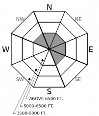
| Wind Direction: | West | Southwest | West |
| Wind Speed: | 8 to 13, gusting to 20 | 5 to 10, gusting to 20 | 8 to 13, gusting to 20 |
| Snowfall: | 1" to 3" in. | T to 2" in. | 1" to 3" in. |
| Snow Line: | 2500' | 2500' | 2000' |


