| Monday | Monday Night | Tuesday | |
|---|---|---|---|
| Cloud Cover: | Mostly Cloudy | Mostly Cloudy | Mostly Cloudy |
| Temperatures: | 30 to 39 deg. F. | 18 to 23 deg. F. | 24 to 31 deg. F. |
| Wind Direction: | Southwest | Southwest | Southwest |
| Wind Speed: | 16G31 | 15G30 | 13 |
| Snowfall: | 0" in. | 1" to 2" in. | 2" to 3" in. |
| Snow Line: | 4000' | 3000' | 2000' |
Flathead Range and Glacier National Park
How to read the forecast
Isolated avalanche hazards linger where more than a few inches of new and drifted snow has accumulated since Saturday night. Avoid the exceptions to the generally safe conditions by avoiding pockets of drifted snow and confined terrain where sluffs of loose snow can have outsized consequences.

1. Low
?
Above 6500 ft.
1. Low
?
5000-6500 ft.
1. Low
?
3500-5000 ft.
- 1. Low
- 2. Moderate
- 3. Considerable
- 4. High
- 5. Extreme
-
Type ?
-
Aspect/Elevation ?

-
Likelihood ?CertainVery LikelyLikelyPossible
 Unlikely
 -
Size ?HistoricVery LargeLargeSmall

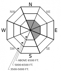
Several bouts of moderate winds (northwesterly Friday night; southwesterly since) have drifted snow into thin slabs that are sensitive to a person's weight and can pose a hazard where they have outsized consequences. Look for pockets of drifted snow 8 inches or so deep near summits and the crest of the Flathead Range. Pick lines that don't funnel you and debris from these slabs over cliffs or into gullies and chutes.
-
Type ?
-
Aspect/Elevation ?

-
Likelihood ?CertainVery LikelyLikelyPossible
 Unlikely
 -
Size ?HistoricVery LargeLargeSmall

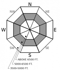
On steep slopes with more than a few inches of loose new snow, small triggered and natural loose snow avalanches may become a hazard if it warms enough to get sticky and wet. Roller balls releasing from your uptrack or turns are a good sign of wet snow hazard. Monitor the snow surface for quickly changing conditions and be ready to move towards less consequential terrain or lower-angled slopes if sluffs become large enough to push you around.
The northern Flathead Range won the hand in Saturday night's snowfall, though it was nickel-ante poker and the pot was only 4 inches or so of fresh snow. Accumulations were 1 to 2 inches in John F. Stevens Canyon, maybe the same in the Swan Range and Southern Whitefish, and negligible in the northern Whitefish Range. Gusty winds during and after the snowfall blew enough of this snow around to form isolated wind slabs that were sensitive to a rider's weight on steep, upper elevation leeward terrain. One party reported unintentionally triggering a slab on a northeast-facing slope above 7000 feet. This hazard will linger today on high, cold slopes near the crest of the Flathead Range and near summits in the Lake McDonald area. Winds are increasing today and shifting to the southwest, expanding the distribution and potential size.
Several parties reported triggering loose dry sluffs on shady mid and upper elevation terrain yesterday. I found that these fanned out wider and entrained more snow than I'd expect with only an inch or two of new snow, because they were entraining older, faceted snow. Look for this hazard on high, cold slopes where the surface snow is loose and unaffected by winds of the past few days.
Many southerly slopes shed their new snow in yesterday's sun; several parties in the Flathead Range reported small natural wet loose slides Sunday afternoon on steep, sunny, mid and low elevation slopes. I don't expect much more natural activity with today's cloud cover. The cloud cover might, however, allow the snow on shady, mid-elevation slopes to get wet, particularly in those areas where clouds don't arrive until later in the day. If that happens, rider-triggered sluffs on steep slopes will likely involve dense moist or wet snow that's tough to escape. You'll be able to recognize if this is happening by observing rollerballs or sticky, gloppy snow underfoot.
Today, the forecast region will see breezy southwest winds at ridgetops and increasing clouds and snow showers as a cold front approaches from the northwest. Temperatures will be mild. Oernight accumulations look to be 1 to 4 inches, with similar amounts tomorrow.
This forecast applies only to backcountry areas outside established ski area boundaries. The forecast describes general avalanche conditions and local variations always occur. This forecast expires at midnight on the posted day unless otherwise noted. The information in this forecast is provided by the USDA Forest Service who is solely responsible for its content.


