THIS AVALANCHE FORECAST EXPIRED ON March 17, 2020 @ 11:59 pm
Avalanche Forecast published on March 17, 2020 @ 6:59 am
Issued by Cam Johnson - Flathead Avalanche Center

Flathead Range and Glacier National Park

How to read the forecast

Warm temperatures and clear skies will cause loose wet avalanches on sun-baked slopes. If the snow becomes wet, travel quickly and one at a time through steep, sun-exposed terrain. Be wary of wind slabs in unusual locations. Choose terrain sheltered from the wind and only expose one rider at a time in the event you trigger an unexpected slab avalanche.

2. Moderate

?

Above 6500 ft.
Heightened avalanche conditions on specific terrain features. Evaluate snow and terrain carefully; identify features of concern.

2. Moderate

?

5000-6500 ft.
Heightened avalanche conditions on specific terrain features. Evaluate snow and terrain carefully; identify features of concern.

2. Moderate

?

3500-5000 ft.
Heightened avalanche conditions on specific terrain features. Evaluate snow and terrain carefully; identify features of concern.
    Heightened avalanche conditions on specific terrain features. Evaluate snow and terrain carefully; identify features of concern.
  • 1. Low
  • 2. Moderate
  • 3. Considerable
  • 4. High
  • 5. Extreme
Avalanche Problem 1: Wind Slab
  • Type ?
  • Aspect/Elevation ?
  • Likelihood ?
    Certain
    Very Likely
    Likely
    Possible
    Unlikely
  • Size ?
    Historic
    Very Large
    Large
    Small

Strong northerly and easterly winds this weekend drifted snow onto a variety of slopes and aspects with no real pattern. Yesterday, a rider unintentionally triggered a small wind slab at the bottom of their run on a steep breakover. This is a gentle reminder that wind slabs have yet to heal and of the tricky loading pattern. Wind slabs may also be hard to detect visually, because they’re camouflaged by a few inches of low density snow. Move quickly to wind sheltered locations if you feel hollow slabs of snow under your ski or machine. This may require you to dig with your hand or poke your pole into the snow to feel beneath surface snow.

Avalanche Problem 2: Loose Wet
  • Type ?
  • Aspect/Elevation ?
  • Likelihood ?
    Certain
    Very Likely
    Likely
    Possible
    Unlikely
  • Size ?
    Historic
    Very Large
    Large
    Small

Wet loose avalanches will become a concern on sun-baked slopes after the warm sun breaks down recently formed crusts and wind hardened surfaces. Though we expect most of them to be relatively small, they will be more of a concern in longer running paths where they can entrain enough snow to bury, injure, or kill you. Rocky areas exposed to the sun will be the first zones to slide. Rollerballs and pinwheels are your initial cue to seek cold, dry snow on shady aspects.

Forecast discussion

There is a gathering of avalanche problems out there today, luckily far less than 10. These problems are a bit more obvious and easy to manage than the most talked about problem today. However, a sneaky wind slab problem still lurks in obscure locations and has proven more challenging to identify.

In the past two days, riders and forecasters have highlighted a tricky loading pattern from recent northeasterly winds. On Sunday at Lake McDonald, Zach described wind slabs as hidden with no real pattern. Yesterday in the Flathead Range, I found isolated pockets of wind slabs on a variety of aspects and elevations. Other reports of running into pockets of wind slabs and variable conditions of wind hardened surfaces came out of the southern end of Glacier National Park, as well as the Whitefish Range. What do we do with this information? Treat each slope with a fresh set of eyes. Expose one rider at a time and be mindful of what is below you. A small, hard wind slab can have deadly consequences if caught above a cliff band or island of trees.

The more obvious problem will result from solar radiation and warm temperatures. Yesterday, riders reported a few small to large (D1 to D2) wet loose avalanches in the Flathead Range and Glacier NP (example 1, example 2). Other observers noted glopping skins, rollerballs, and isolated wet loose avalanches out of south facing, steep, rocky terrain. Today we can expect more of the same. Overnight temperatures dropped into the teens and low twenties, forming a crust on sun affected slopes. The sun crust, along with snow surfaces already hardened by the wind, will be slow to soften and delay wet snow concerns. If your plan has you crossing underneath sun-baked avalanche paths, or ascending them during morning hours, move quickly and retreat to cold, north facing aspects if you feel the crust break down and the surface becomes wet. We can’t rule out the possibility of cornice fall with the warm sun beating down on them. Give ridgelines a wide berth and don’t get caught below large, overhanging cornices.

Weather and CURRENT CONDITIONS
weather summary

Expect another balmy day before a quick-hitting cold front. Freezing levels will hover around 5500’ with mostly sunny skies. Winds will be light out of the northeast.

Two-Day Mountain Weather Forecast Produced in partnership with the Missoula NWS
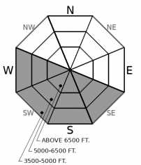
For 5000 ft. to 7000 ft.
Tuesday Tuesday Night Wednesday
Cloud Cover: Partly Cloudy Partly Cloudy Partly Cloudy
Temperatures: 28 to 36 deg. F. 7 to 12 deg. F. 22 to 30 deg. F.
Wind Direction: Northeast Northeast Northeast
Wind Speed: 10G20 17G32 10G21
Snowfall: 0" in. 0" in. 0" in.
Snow Line: 2500' 500' 500'
Disclaimer

This forecast applies only to backcountry areas outside established ski area boundaries. The forecast describes general avalanche conditions and local variations always occur. This forecast expires at midnight on the posted day unless otherwise noted. The information in this forecast is provided by the USDA Forest Service who is solely responsible for its content.