THIS AVALANCHE FORECAST EXPIRED ON March 16, 2020 @ 11:15 pm
Avalanche Forecast published on March 16, 2020 @ 6:15 am
Issued by Blase Reardon - Flathead Avalanche Center

Flathead Range and Glacier National Park

How to read the forecast

Two main clues to today's avalanche hazards: soft snow that's getting wet from sustained sun, and hard, hollow-feeling snow that's been packed by recent winds. Move on to shadier or lower-angled slopes if you find the first, and avoid crossing the second on steep slopes. The wet snow avalanche hazard will develop through the day; the wind slabs are more widespread at upper elevations, though you might find them in unusual spots.

2. Moderate

?

Above 6500 ft.
Heightened avalanche conditions on specific terrain features. Evaluate snow and terrain carefully; identify features of concern.

3. Considerable

?

5000-6500 ft.
Dangerous avalanche conditions. Careful snowpack evaluation, cautious route-finding and conservative decision-making essential.

2. Moderate

?

3500-5000 ft.
Heightened avalanche conditions on specific terrain features. Evaluate snow and terrain carefully; identify features of concern.
    Dangerous avalanche conditions. Careful snowpack evaluation, cautious route-finding and conservative decision-making essential.
  • 1. Low
  • 2. Moderate
  • 3. Considerable
  • 4. High
  • 5. Extreme
Avalanche Problem 1: Loose Wet
  • Type ?
  • Aspect/Elevation ?
  • Likelihood ?
    Certain
    Very Likely
    Likely
    Possible
    Unlikely
  • Size ?
    Historic
    Very Large
    Large
    Small

Triggered and natural wet loose avalanches pose a hazard on and below steep slopes that receive direct, sustained sun today and where the snow surface hasn't been hardened by recent winds. Snowballs rolling downslope in fan-shaped patterns are a clear sign that conditions are ripening for these slides. The debris from these slides can be difficult to escape, making slopes above trees, cliffs or gullies more dangerous. Plan your day so you don't have to cross under steep, sun-exposed gullies, stop in spots where slides can't hit you from above, and head for lower-angled, shadier slopes as the near-surface snow gets wet. 

Avalanche Problem 2: Wind Slab
  • Type ?
  • Aspect/Elevation ?
  • Likelihood ?
    Certain
    Very Likely
    Likely
    Possible
    Unlikely
  • Size ?
    Historic
    Very Large
    Large
    Small

Keep your distance from hard slabs of drifted snow leftover from the recent blast of easterly and northerly winds. These slabs may be hard to detect visually, because they're camouflaged by a few inches of low-density snow. If you feel them underfoot or it's hard to edge your sled, punch a hand or pole into the snow to check how thick they are. Head for an exit if you find more than about 8 inches of hard snow sitting on soft snow. You may find these well below ridgelines and in other unusual spots. They'll be tough to manage in confined terrain, so pick ascents and descents that allow you plenty of wiggle room. 

Forecast discussion

Thanks to everyone who contributed to this morning's forecast by submitting observations! It seems most people were in the same three drainages in the Flathead Range, so apparently our social distancing skills need work. Many thanks too to the hard-working ski patrol at Whitefish Mountain Resort for all their reports this winter and to the Patrol Fund for their excellent avalanche safety courses. 

This morning's temperatures are running 10 to 25 degrees warmer than yesterday, except at Marias Pass, where arctic air is still holding on. With another day of mostly clear skies, light east winds, and temperatures warming to freezing at mid elevations, expect a Loose Wet snow hazard to develop on sunny slopes, with natural and triggered slides possible or likely, depending on location. Across the region, roughly 2-18 inches of recent and/or drifted snow sits on hard surfaces - a thick, slick melt-freeze crust that's most widespread at low and mid elevations and hard, wind-packed surfaces at some upper elevations. Although it took me a few pushes to get the snow above this crust moving yesterday in the southern Whitefish Range, the debris ran far. The potential for large (D2) slides is greatest in the Flathead Range, where recent snowfall was greatest and avalanche paths are steeper for longer. The wet snow avalanche danger may develop on a few shady slopes at mid elevation as well, so don't turn off your spidey senses in that terrain.

The recent blast of powerful northerly and easterly winds has left a nasty wind slab problem at upper elevations across the region, and at mid elevations in the Flathead Range and Glacier National Park. The slabs are hard - 1 finger to pencil - and sit over much softer snow. Several natural avalanches (here and here) involving this combination occurred Saturday, and on Sunday, another natural slide occurred and large column tests propagated easily in the Lake McDonald area. Two of our forecasters turned back from their objectives because of this hazard (example 1, example 2). Three factors make this problem nasty. The hard slabs are distributed somewhat randomly, because winds were channeling and eddying due to local terrain factors. The distinct hardness difference between the slab and underlying snow means they'll be slow to stabilize. And lastly, several inches of new snow has covered wind-damaged surfaces, so it's hard to discern the spots where the slabs exist visually. Zach's video, below, does an excellent job of describing this hazard. Steep, confined terrain like chutes will be tough to manage today, because it will be hard to work around any slabs that exist.

Weather and CURRENT CONDITIONS
weather summary

Warm sumo wins. For now. A beautiful spring day in the mountains, with light easterly winds and daytime highs climbing to about freezing at mid-elevations, though it will feel warmer with direct sun under clear skies. Expect more of the same tomorrow. Cold sumo gets up off the mat Tuesday night, as arctic air pushes across the divide again. 

Two-Day Mountain Weather Forecast Produced in partnership with the Missoula NWS
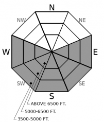
For 5000 ft. to 7000 ft.
Monday Monday Night Tuesday
Cloud Cover: Mostly Clear Mostly Clear Partly Cloudy
Temperatures: 28 to 34 deg. F. 8 to 13 deg. F. 30 to 37 deg. F.
Wind Direction: Northeast Southeast Northeast
Wind Speed: 5 to 10 5 to 10 9G21
Snowfall: 0" in. 0" in. 0" in.
Snow Line: 1500' 2000' 3000'
Disclaimer

This forecast applies only to backcountry areas outside established ski area boundaries. The forecast describes general avalanche conditions and local variations always occur. This forecast expires at midnight on the posted day unless otherwise noted. The information in this forecast is provided by the USDA Forest Service who is solely responsible for its content.