| Saturday | Saturday Night | Sunday | |
|---|---|---|---|
| Cloud Cover: | Mostly Cloudy | Partly Cloudy | Mostly Clear |
| Temperatures: | -3 to 2 deg. F. | -11 to -6 deg. F. | 18 to 23 deg. F. |
| Wind Direction: | Northeast | Northeast | Northeast |
| Wind Speed: | 15 to 30, G50 | 10 to 20, G30 | 5 to 15 |
| Snowfall: | 1" to 3" in. | 0" in. | 0" in. |
| Snow Line: | 0' | 0' | 0' |
Flathead Range and Glacier National Park
How to read the forecast
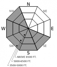
Keep it short, simple, and out of the wind today. Blustery northeast winds are thickening wind slabs in wind hammered terrain. Severe wind chill will complicate decision making and any attempts at rescue.

2. Moderate
?
Above 6500 ft.
2. Moderate
?
5000-6500 ft.
2. Moderate
?
3500-5000 ft.
- 1. Low
- 2. Moderate
- 3. Considerable
- 4. High
- 5. Extreme
-
Type ?
-
Aspect/Elevation ?

-
Likelihood ?CertainVery LikelyLikelyPossible
 Unlikely
 -
Size ?HistoricVery LargeLargeSmall

Northeasterly winds continue to blast their way through some basins while sparing others. In terrain affected by winds, you'll find thick, hard drifts littered behind trees and downwind of saddles, ridges, and rock outcrops. Winds are coming from the opposite direction than that we normally see and forming slabs in unusual locations. Don't mess with these land mines; they'll be the kind that can break above you or sweep you off your feet or machine. It will be obvious if you are in enemy territory; the trees will be swaying, the snow surface will be stiff and textured with thick dunes of hard wind deposits, and you may see more blowing snow. Retreat to a wind protected basin and avoid crossing over the obvious drifts in steep terrain.
You know that feeling of uneasiness. Will it impact my area? How bad will it be when it gets here? Where can I go to stay away from it?
These are the questions we forecasters ask ourselves with northeast wind events. They are a novel wind direction, unpredictable, and hard to map because of lack of wind sensor data. Observers in the Middle Fork yesterday reported light winds and generally stable conditions, yet anyone who tried to sleep last night in Flathead Valley can vouch that yes, the winds were indeed blowing in some places. Our neighbors near Fernie found themselves in a wind-affected basin yesterday, with blowing snow, shooting cracks, and rapidly forming wind slabs. Today we expect slabs to be thicker, harder, but more difficult to trigger. That means irregular feedback underfoot but fractures uphill of you. You don't want to mess with hard slabs, especially in terrain where you could get pushed into trees, down chutes, or into rocks. Wind chill is a serious consideration today; this morning's wind chills are -45 at Big Mountain and -60 on Sperry Glacier. A simple mishap, gear failure, or twisted knee in these conditions can quickly turn dangerous.
So where can you get out of the wind? Although there are lots of holes in the data, our weather station map is a good starting point, showing winds battering the Southern Whitefish Range, Lake McDonald area, and likely the western side of the Swan. This wind forecast map from Windy.com is showing a decent representation of where we are expecting the strongest winds. If you can hunt down a wind-sheltered basin, the avalanche danger is low and you can find good, soft powder with some shallow sluff management. It looks like a few inches of new snow have accumulated in the Flathead Range and John F. Stevens Canyon, and a couple more are expected today.
Arctic air centered over Alberta is flooding into Northwest Montana, bringing frigid temperatures and strong northeasterly winds. Winds start to phase out over the next 24 hours. High pressure starts moving our way on Sunday. Temperatures will rebound and skies will start clearing tomorrow, with a warming, sunny trend into the work week.
This forecast applies only to backcountry areas outside established ski area boundaries. The forecast describes general avalanche conditions and local variations always occur. This forecast expires at midnight on the posted day unless otherwise noted. The information in this forecast is provided by the USDA Forest Service who is solely responsible for its content.


