| Thursday | Thursday Night | Friday | |
|---|---|---|---|
| Cloud Cover: | Increasing Clouds | Mostly Cloudy | Mostly Cloudy |
| Temperatures: | 21 to 29 deg. F. | 4 to 10 deg. F. | 8 to 16 deg. F. |
| Wind Direction: | West | North | Northeast |
| Wind Speed: | 12G23 | 13G24 | 22G36 |
| Snowfall: | 0" in. | 0" in. | 2" to 3" in. |
| Snow Line: | 1000' | 1000' | 0' |
Whitefish Range
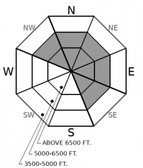
How to read the forecast
Winter has returned, along with winter avalanche problems. Watch for recently drifted snow on the down-wind sides of ridges and on the sidewalls of chutes. Assess how well slabs are bonding before committing to bigger terrain. Shooting cracks in dense drifts, and tender cornices should raise your hackles.

2. Moderate
?
Above 6500 ft.
2. Moderate
?
5000-6500 ft.
1. Low
?
3500-5000 ft.
- 1. Low
- 2. Moderate
- 3. Considerable
- 4. High
- 5. Extreme
-
Type ?
-
Aspect/Elevation ?

-
Likelihood ?CertainVery LikelyLikelyPossible
 Unlikely
 -
Size ?HistoricVery LargeLargeSmall

Up to 5" of new snow and moderate winds grew tender cornices and created sensitive drifts yesterday in the Whitefish Range. Small test slopes easily produced wind slab avalanches and shooting cracks. Slabs have developed atop slick crusts and weak, older snow. They will take time to heal. Assess how well they are bonding on small test slopes before committing to bigger terrain. Look for rounded drifts on the down-wind sides of ridges, trees, and rollovers. Dense snow that cracks around you mean that you can still trigger wind slabs on steep, leeward terrain. Lower slope angles or sheltered terrain are the antidote.
After a warm, and unimpressive start to the month, at last! New snow! It’s like Christmas all over again. Though your presents are either wrapped in dense packaging, or padded with those little Styrofoam balls.
Recent snowfall varied widely across the region. The Swan Range was the loser, for once, with a paltry 3 inches. The Whitefish Range picked about 5 inches or more of new snow. The storm overproduced further east. The Middle Fork and John Stevens Canyon saw heavy convective showers of rimed snow and graupel, and was refreshed with up to a foot of new. The winds were consistent out of the west and observers noted wind loading, shooting cracks, reactive cornices, and sensitive wind slabs. In sheltered areas, skiers could produce small loose dry avalanches. Warm temperatures and rain at lower elevations created rollerballs and a few, small, wet loose avalanches.
Cold temperatures overnight have refrozen lower elevations and maintained the dry, wintry snow and lingering instabilities as you gain elevation. The new snow is loose in sheltered areas and dense where the winds have had their way. Where the most snow fell, it is upside-down in places. It rests on a few inches of very soft snow from Sunday, which in turn sits on top of slick melt-freeze crusts and wind board. Observers in Kimmerly Basin even found a recent layer of surface hoar that was reactive under newer snow.
Winter has returned. Today’s quite weather makes you want to enjoy your 2nd Christmas gifts. But remember that the new snow – slabby or loose – will need time to bond to slick bed surfaces, and the soft weak snow above them. Unwrap your presents with caution. You may find a white elephant if you’re not careful.
Today will be mostly clear until clouds build down from Canada ahead of the next cold front. Temperatures will be more seasonable before dropping precipitously with the incoming arctic air. Winds have tempered from a roar to a yawn. That changes with the next winter weather system this weekend.
This forecast applies only to backcountry areas outside established ski area boundaries. The forecast describes general avalanche conditions and local variations always occur. This forecast expires at midnight on the posted day unless otherwise noted. The information in this forecast is provided by the USDA Forest Service who is solely responsible for its content.


