THIS AVALANCHE FORECAST EXPIRED ON March 7, 2020 @ 11:44 pm
Avalanche Forecast published on March 7, 2020 @ 6:44 am
Issued by Blase Reardon - Flathead Avalanche Center

Whitefish Range

How to read the forecast

Where it feels like winter today, you can trigger small but potentially dangerous slabs of drifted snow at upper elevations. Cornices continue to weaken; don't dawdle below these, and stay well back on ridges. Wet avalanches remain a concern in steep terrain that is slushy from warm temperatures and sun, or receives rain on dry snow today.

2. Moderate

?

Above 6500 ft.
Heightened avalanche conditions on specific terrain features. Evaluate snow and terrain carefully; identify features of concern.

2. Moderate

?

5000-6500 ft.
Heightened avalanche conditions on specific terrain features. Evaluate snow and terrain carefully; identify features of concern.

2. Moderate

?

3500-5000 ft.
Heightened avalanche conditions on specific terrain features. Evaluate snow and terrain carefully; identify features of concern.
    Heightened avalanche conditions on specific terrain features. Evaluate snow and terrain carefully; identify features of concern.
  • 1. Low
  • 2. Moderate
  • 3. Considerable
  • 4. High
  • 5. Extreme
Avalanche Problem 1: Wind Slab
  • Type ?
  • Aspect/Elevation ?
  • Likelihood ?
    Certain
    Very Likely
    Likely
    Possible
    Unlikely
  • Size ?
    Historic
    Very Large
    Large
    Small

You can trigger small slabs on steep slopes where more than about 8 inches of new and drifted snow has accumulated. The hazard will be isolated to steep start zones downwind of large, open slopes, unless snowfall totals exceed forecasts and there's more snow available for transport. Look for these slabs at the tops of chutes and below saddles. Terrain traps like cliffs, trees, and gullies can exaggerate the consequences of small slides.  

Avalanche Problem 2: Cornice
  • Type ?
  • Aspect/Elevation ?
  • Likelihood ?
    Certain
    Very Likely
    Likely
    Possible
    Unlikely
  • Size ?
    Historic
    Very Large
    Large
    Small

Large cornice falls remain a possibility after three consecutive days of minimal, if any, refreeze at high elevations. Cornice failures don’t give warning signs other than their obvious presence looming above you. Don’t hang out below cornices today; falling cornices are dangerous in and of themselves, and they have potential to trigger slab avalanches below. Give cornices a wide berth while traveling on ridgelines because they are notorious for breaking further back than expected. 

Avalanche Problem 3: Loose Wet
  • Type ?
  • Aspect/Elevation ?
  • Likelihood ?
    Certain
    Very Likely
    Likely
    Possible
    Unlikely
  • Size ?
    Historic
    Very Large
    Large
    Small

Triggering small wet loose slides remains a possibility on very steep slopes where the near-surface snow surface is wet. Be alert for rollerballs and pinwheels of wet snow fanning downslope from your machine or boards. If these coalesce into sluffs that pull wet snow down with them, especially in gullies, move on to slopes where the snow surface is refrozen or dry, or to lower-angled slopes. 

Forecast discussion

Complicated weather makes for uncertain snow and temperature forecasts, and thus, some uncertainty about the distribution and sensitivity of today's avalanche hazards. In other words, your mileage may vary. Don't let the hunt for good snow blind you to developing hazards.

You're most likely to find trouble where you find freshly-formed slabs of drifted snow. A few inches of new snow should start replenishing the supply of snow available for wind transport at upper elevations. The Wind Slab avalanche hazard will develop soonest and be most widespread in the Whitefish Range and then near the Continental Divide, the two areas favored for snowfall today. Any freezing rain that falls will limit drifting snow and the extent of this hazard.In areas without much fresh snow, older slabs that formed in the past week may remain unstable where they're markedly harder than snow beneath them. 

Whale-sized cornices guard many slopes where you might find these older slabs. These unusually-large cornices are gradually losing strength under our unseasonably warm temperatures. They pose a lingering and unpredictable hazard in their own right. The snow that comprises these monsters is hard, and any falling chunks will travel far on the relatively firm snow surfaces below them. 

Observers and forecasters yesterday reported few signs of wet snow instability. Data from most stations shows another night with brief, if any, refreezes. Forecasts for today call for above freezing temperatures and overcast skies at low and mid elevations. Those three factors indicate that at those elevations, triggered wet snow avalanches remain a possibility on very steep slopes - those about 40 degrees or steeper. The hazard will be more widespread in the Swan and Flathead Ranges. It will diminish as temperatures cool this afternoon and evening. 

A video summary of the past week's conditions is below:


Weather and CURRENT CONDITIONS
weather summary

Our nice neighbors to the north will get nice things today, as a storm brushes past our region. Most of the moisture will stay to the west and north this morning, then spread south this afternoon. Expect a trace to 4" of new snow by sunset, with the Whitefish Range favored. Cold air east of the Continental Divide complicates the picture; the Marias Pass and - less likely - the Lake McDonald areas could also see a few inches of snow today. Temperatures will hover near freezing at 6500 feet this morning before cooling this afternoon. Tonight, conditions should be more seasonable, with temperatures in the 20s and a few inches of snow across the region.  

Two-Day Mountain Weather Forecast Produced in partnership with the Missoula NWS
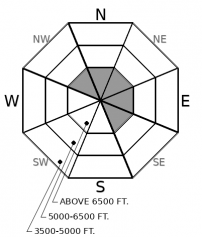
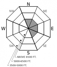
For 5000 ft. to 7000 ft.
Saturday Saturday Night Sunday
Cloud Cover: Mostly Cloudy Mostly Cloudy Mostly Cloudy
Temperatures: 29 to 35 deg. F. 16 to 19 deg. F. 23 to 30 deg. F.
Wind Direction: South Southwest Southwest
Wind Speed: 14G25 13G26 15G29
Snowfall: 3" to 5" in. 1" to 2" in. 0" in.
Snow Line: 5000' 2500' 1000'
Disclaimer

This forecast applies only to backcountry areas outside established ski area boundaries. The forecast describes general avalanche conditions and local variations always occur. This forecast expires at midnight on the posted day unless otherwise noted. The information in this forecast is provided by the USDA Forest Service who is solely responsible for its content.