| Wednesday | Wednesday Night | Thursday | |
|---|---|---|---|
| Cloud Cover: | Mostly Cloudy | Partly Cloudy | Mostly Cloudy |
| Temperatures: | 23 to 30 deg. F. | 11 to 15 deg. F. | 32 to 40 deg. F. |
| Wind Direction: | West | Southwest | South |
| Wind Speed: | 35G57 | 16G39 | 14G26 |
| Snowfall: | 1" to 2" in. | 0" in. | 0" in. |
| Snow Line: | 1500' | 500' | 2000' |
Whitefish Range
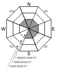
How to read the forecast
Small slabs may develop below corniced ridges and on the sidewalls of chutes. Watch for snow blowing onto isolated, leeward slopes. Use caution on wind-loaded slopes with terrain traps below. Cliff bands and dense trees will increase the consequences of even a small slide. Avoid spending time below large cornices.

1. Low
?
Above 6500 ft.
1. Low
?
5000-6500 ft.
1. Low
?
3500-5000 ft.
- 1. Low
- 2. Moderate
- 3. Considerable
- 4. High
- 5. Extreme
-
Type ?
-
Aspect/Elevation ?

-
Likelihood ?CertainVery LikelyLikelyPossible
 Unlikely
 -
Size ?HistoricVery LargeLargeSmall

Strong winds will have a few inches of new snow to drift onto leeward terrain. Expect small slabs on the down-wind side of ridges, rollovers, and trees. The sidewalls of chutes and gullies are also suspect. You can spot the most favored slopes from afar by watching snow blow onto them. Cornices will point to wind-loaded terrain below. Slabs may develop further down slope than usual, and in normally sheltered areas. Wind blown snow will be dense, rippled, and can crack under you. Terrain traps like cliff bands and dense trees below you will increase the consequences of getting knocked off your feet by a small slab.
It gives me no joy to say that the safest riding today with be where the snow is crusty. New snow will come and go quickly this morning, falling and drifting onto sun crusts, melt-freeze crusts, rime crusts, wind board...
The Flathead Range, and east to Marias Pass look favored for up to 5 inches. The Swan Range may see a little less. An inch or two looks possible for the Whitefish Range. A quick refresh would be welcome, except that the winds of the past few days will only be stronger today. With winds as strong as they are, I expect slabs to form in unusual places: openings in trees and at lower elevations than is normal. If snowfall in the Flathead Range exceeds expectations, wind slabs will become larger, more widespread, and more likely.
Cornices will continue to grow over many ridgelines. Cornices are dangerous in and of themselves. Give these giant prows, and the slopes below them, a wide berth.
In isolated areas, persistent weak layers of surface hoar and near-surface facets have been found under the storm snow from 2/23. They seem to be dormant in most places with no propagation in tests and no recent avalanches on adjacent slopes.
Conditions could change significantly with above average temperatures under a high pressure ridge on Thursday and Friday.
Strong westerly winds are expected again today. Numerous snow showers diminish by this afternoon with increasing sunshine. A ridge will bring warmer than normal temperatures Thursday and Friday. Another weather system is on tap for the weekend.
This forecast applies only to backcountry areas outside established ski area boundaries. The forecast describes general avalanche conditions and local variations always occur. This forecast expires at midnight on the posted day unless otherwise noted. The information in this forecast is provided by the USDA Forest Service who is solely responsible for its content.


