| Tuesday | Tuesday Night | Wednesday | |
|---|---|---|---|
| Cloud Cover: | Partly Cloudy | Mostly Cloudy | Mostly Cloudy |
| Temperatures: | 29 to 36 deg. F. | 19 to 24 deg. F. | 24 to 31 deg. F. |
| Wind Direction: | West | Southwest | West |
| Wind Speed: | 27G41 | 23G45 | 36G56 |
| Snowfall: | 0" in. | 2" to 4" in. | 2" to 3" in. |
| Snow Line: | 4000' | 4000' | 2000' |
Swan Range
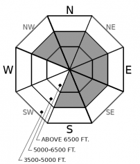
How to read the forecast
You can avoid triggering wind slab avalanches today by staying away from steep, leeward terrain where snow has been blowing. Cornices will point towards rounded drifts on the slopes below. Give both a healthy margin to stay out of trouble. Dense, rippled snow that cracks beneath you is a sign that you’ve already wandered onto unstable slabs. Sheltered terrain will have softer snow and better riding conditions.

2. Moderate
?
Above 6500 ft.
1. Low
?
5000-6500 ft.
1. Low
?
3500-5000 ft.
- 1. Low
- 2. Moderate
- 3. Considerable
- 4. High
- 5. Extreme
-
Type ?
-
Aspect/Elevation ?

-
Likelihood ?CertainVery LikelyLikelyPossible
 Unlikely
 -
Size ?HistoricVery LargeLargeSmall

Be on the lookout for round, dune-shaped drifts below ridges and on the sidewalls of gullies. Fresh slabs may be relatively soft, but will be more sensitive today. They will be bigger as you gain elevation. The snow surface will feel denser and may have a rippled texture. Older, harder drifts may lurk under recent snow. These will be more stubborn, but can break in less predictable ways – above you or across the slope. Treat steep leeward slopes with suspicion, especially where you see blowing snow. Shooting cracks mean unstable wind slabs. Don’t travel over cornices and avoid spending time on the slopes below them.
Strong winds have been the headliner for the past couple of days. Observers have been reporting moderate and strong winds since Sunday afternoon. Actual wind slab formation, so far, has been limited because there has been little snow available for transport on windward aspects. A group in the Middle Fork saw blowing snow on the highest peaks yesterday. Zach found small and isolated drifts in John Stevens Canyon. Observers in the Whitefish Range found less blowing snow (example 1, example 2). The Continental Divide and Swan Range picked up a few inches of snow overnight providing a little more fuel for the continuing winds. Fresh slabs may be more widespread in leeward terrain as a result.
Cornices have grown and loom over many ridgelines. Winds slabs are dangerous if you wander onto dense, drifted snow. Cornices are dangerous in and of themselves. Give these giant prows, and the slopes below them, a wide berth.
Temperatures climb near or above freezing into the middle elevations today, with a chance for cloud cover to decrease towards the end of the day. The danger of wet instabilities will hinge on how much loose snow is at the surface. Areas with more soft snow above recent crusts have the highest chance of producing more than a few pinwheels. In places that have seen favored snowfall, like the Swan Range, and on northerly aspects at mid elevations, pay attention to if and how deep the snow is getting moist. If rollerballs start to collect volume, be wary of loose wet avalanches, especially around terrain traps.
In isolated areas, persistent weak layers of surface hoar and near-surface facets have been found under the storm snow from 2/23. They seem to be dormant in most places with no propagation in tests and no recent avalanches on adjacent slopes. If you climb or ride steep, convex, mid-elevation slopes, go one at a time and keep your partners in sight, as insurance against surprises.
Upcoming Avalanche Courses: Level 1 Motorized avalanche course, March 6th-8th. An interactive program covering the fundamentals of avalanche hazards including awareness and stability assessments. Registration Link: https://ace.fvcc.edu/ShowSchedule.awp?&Mode=GROUP&Group=AVAL&Title=Avalanche+Safety
Strong westerly winds and warm temperatures are the theme for today. An upper level jes and surface cold front increase winds into Wednesday with the potential for several more inches of snow beginning tonight and tomorrow. High pressure builds Thursday with much warmer temps and clear skies.
This forecast applies only to backcountry areas outside established ski area boundaries. The forecast describes general avalanche conditions and local variations always occur. This forecast expires at midnight on the posted day unless otherwise noted. The information in this forecast is provided by the USDA Forest Service who is solely responsible for its content.


