| Monday | Monday Night | Tuesday | |
|---|---|---|---|
| Cloud Cover: | Mostly Cloudy | Mostly Cloudy | Mostly Cloudy |
| Temperatures: | 25 to 31 deg. F. | 22 to 26 deg. F. | 29 to 36 deg. F. |
| Wind Direction: | West | West | West |
| Wind Speed: | 31 | 28G38 | 26 |
| Snowfall: | 0 to 1" in. | 3" to 4" in. | 0" in. |
| Snow Line: | 2500' | 3500' | 4000' |
Whitefish Range
Swan Range
How to read the forecast
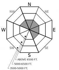
At upper elevations, slabs of drifted snow pose an isolated hazard. These freshly-formed slabs are most common in the terrain that harbors good riding conditions, so take a minute to assess conditions and consequences before climbing or dropping into gullies and bowls with leeward start zones and looming cornices at ridelines.

1. Low
?
Above 6500 ft.
1. Low
?
5000-6500 ft.
1. Low
?
3500-5000 ft.
- 1. Low
- 2. Moderate
- 3. Considerable
- 4. High
- 5. Extreme
-
Type ?
-
Aspect/Elevation ?

-
Likelihood ?CertainVery LikelyLikelyPossible
 Unlikely
 -
Size ?HistoricVery LargeLargeSmall

Approach terrain that collects wind-blown snow with caution, eyes peeled for fresh drifts and dense, hollow-feeling snow. These can break a foot or so deep, and can be dangerous above terrain that magnifies the likelihood of trauma or deep burials, like cliffs, trees, and gullies. You're most likely to find both fresh slabs and older slabs above about 7000 feet and near the Continental Divide. While a few inches of new snow may mask older slabs, you can still detect these by probing and the feel of snow underfoot.
Snow showers produced a few inches of snow yesterday morning, mostly in the Middle Fork and near the Continental DIvide. Winds picked up early Sunday afternoon, with ridgeline stations reporting gusts of 25 to 50 mph. Observers and forecasters reported blowing snow in the Flathead and Apgar Ranges. With little loose snow on windward aspects, the slab-making machine had a supply chain issue and the wind-drifted snow wasn't forming slabs, though it was adding fragile lips to cornices. Winds are forecast to continue today, with a few inches more snow possible. Be alert for thin, freshly-formed slabs of drifted snow if you venture near ridgelines and and summits. You may also find these in leeward basins below convex rollovers or around other terrain prone to collecting wind-blown snow. The freshly formed slabs will be larger in the Flathead Range and Glacier National Park; peaks there have bigger fetches and start zones above 7000 feet.
We've dropped the Persistent Slab avalanche problem involving surface hoar and near-surface facets buried 2/23. These layers are still appearing in snow profiles in the terrain, but not propagating in tests and not producing avalanches on adjacent slopes. I'll still climb or ride steep, convex, mid-elevation slopes one at a time and keep my partners in sight, as insurance against surprises.
Models are showing more snow midweek and very warm, sunny weather is forecast for the end of the week. If these conditions verify, we will likely see new snow and wet snow avalanche hazards develop. These conditions will also increase the likelihood of cornice falls and very large avalanches that break near the ground. Expect more hazards and rising danger as the week progresses.
Today's weather will echo yesterday's, with moderate to strong winds at mid and upper elevations, mostly cloudy skies, and a chance for snow showers. Accumulations, if any, will be a few inches at best. More widespread snowfall is forecast to start late this afternoon and continue overnight, with 3-5" accumulating by morning. The Swan Range and Continental Divide look favored. Another system is forecast for midweek before a very warm southwesterly flow arrives later in the week.
This forecast applies only to backcountry areas outside established ski area boundaries. The forecast describes general avalanche conditions and local variations always occur. This forecast expires at midnight on the posted day unless otherwise noted. The information in this forecast is provided by the USDA Forest Service who is solely responsible for its content.


