| Wednesday | Wednesday Night | Thursday | |
|---|---|---|---|
| Cloud Cover: | Mostly Cloudy | Mostly Cloudy | Mostly Cloudy |
| Temperatures: | 24 to 31 deg. F. | 19 to 21 deg. F. | 27 to 34 deg. F. |
| Wind Direction: | Southwest | West | Southwest |
| Wind Speed: | 5 to 15, G 30 | 5 to 15, G 30 | 5 to 15, G 30 |
| Snowfall: | 0" to 1" in. | 0 to 1" in. | 0" in. |
| Snow Line: | 3500' | 3500' | 3500' |
Flathead Range and Glacier National Park
How to read the forecast
Several natural and human triggered slabs of wind drifted snow occurred yesterday in the Flathead Range and Glacier Park. Watch for lingering slab instabilities in leeward or crossloaded terrain features as you gain elevation. Slabs will be most reactive in areas where they formed over fragile weak layers.

2. Moderate
?
Above 6500 ft.
2. Moderate
?
5000-6500 ft.
1. Low
?
3500-5000 ft.
- 1. Low
- 2. Moderate
- 3. Considerable
- 4. High
- 5. Extreme
-
Type ?
-
Aspect/Elevation ?
-
Likelihood ?CertainVery LikelyLikelyPossible
 Unlikely
 -
Size ?HistoricVery LargeLargeSmall

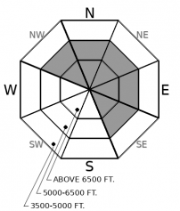
Moderate southwesterly winds continue to drift recent snow into thicker, more cohesive slabs in leeward and crossloaded terrain. Observers yesterday were able to easily trigger small slabs on test slopes, and a natural wind slab was triggered by a sluff. These slabs will be most reactive where they developed over fragile layers of near surface facets or surface hoar, or in areas that see continued wind transport today. Monitor the snow surface for signs of wind transport and thicker drifts. If the snow feels or looks slabby, seek out more protected terrain.
-
Type ?
-
Aspect/Elevation ?
-
Likelihood ?CertainVery LikelyLikelyPossible
 Unlikely
 -
Size ?HistoricVery LargeLargeSmall

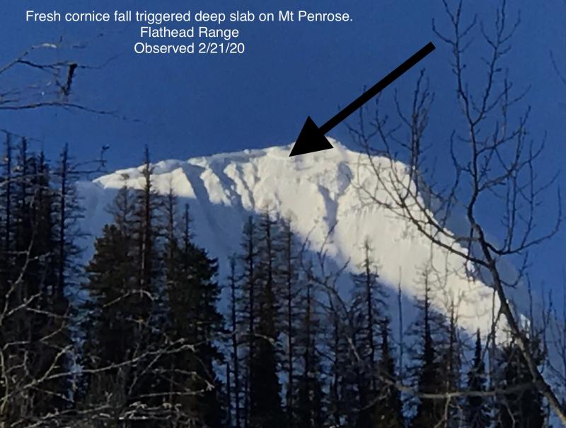
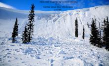
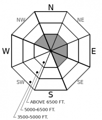
Cornice fall triggered a large avalanche on a northeast-facing slope near Mt. Penrose last Thursday or Friday. The slide is a good reminder of the lingering danger of large avalanches breaking on weak snow near the ground in high alpine bowls and faces in the Flathead Range and Glacier Park on northerly and easterly aspects. While these slides are unlikely, it's good policy to limit your time under steep northerly and easterly start zones near ridges, particularly those with large cornices and active loading. Plumes of snow at ridges are a good sign of the latter.
The Sunday through Monday night storm dumped 2” of SWE in the Swan (up to 2 feet of snow), and about .6” to 1.5” of SWE in the Whitefish, Flathead, and Glacier Park (about a foot of snow, give or take). The storm snow is now settling. Under business-as-usual conditions, settling storm snow heals instabilities and opens the door for steeper terrain. BUT, we aren’t in business-as-usual conditions. That’s because there are persistent weak layers that formed before the storm, during our clear, dry weather. While instabilities aren’t widespread, they can be tricky to spot.
Here’s why: On some slopes, small grained near surface facets and larger feathers of surface hoar survived the sun from last week and the strong winds on Saturday. Today, you are most likely to trigger an avalanche in steep terrain where slabs of recent and wind drifted snow overlap with one of these weak layers, especially surface hoar, because it is the more fragile of the two. We have limited field observations describing the distribution of the surviving weak layers, and those layers that survived are now disguised below fresh powder. The Whitefish and Swan Ranges appear to be hosting more surface hoar right now because more of their terrain was spared from Saturday's winds. The weak layers should be most common in wind-protected terrain and on shadier aspects that face north or east. In some cases, this is well below what we identify as typical start zones near ridgetop.
Slabs over these weak layers are still in their infancy: soft, shallow, and in areas that missed the brunt of snow, few and far between. In much of the Flathead Range and Park, they appear to have formed mostly just in wind drifted terrain. In areas that picked up more snow like the Swan Range, slabs are more widespread and thicker, and more challenging to manage right now. The Whitefish Range, especially the northern part of the range, falls somewhere between the two.
Numerous natural and triggered sluffs have also run in each of the past few days (observation). The size and sensitivity of sluffs is expected to decrease today as the snow settles and snow surfaces remain relatively cool. If we see prolonged sunshine or rain on snow at low elevations, watch for small sluffs around very steep terrain features. These can be trouble if they push you into trees, over rock bands, or drag you down gullies.
A ridge is developing over the Mountain West, bringing a warming trend through the rest of the work week. An embedded shortwave today will bring a few flurries and mostly cloudy skies, with temperatures rising a few degrees warmer than yesterday. Winds around the forecast area are generally light this morning, except for near the Continental Divide, where wind speeds are gusting into the 30's.
This forecast applies only to backcountry areas outside established ski area boundaries. The forecast describes general avalanche conditions and local variations always occur. This forecast expires at midnight on the posted day unless otherwise noted. The information in this forecast is provided by the USDA Forest Service who is solely responsible for its content.


