| Sunday | Sunday Night | Monday | |
|---|---|---|---|
| Cloud Cover: | Mostly Cloudy | Mostly Cloudy | Mostly Cloudy |
| Temperatures: | 28 to 38 deg. F. | 17 to 21 deg. F. | 20 to 30 deg. F. |
| Wind Direction: | Southwest | West | West |
| Wind Speed: | 13G35 | 21G40 | 12G29 |
| Snowfall: | 2" to 6" in. | 5" to 8" in. | 3" to 6" in. |
| Snow Line: | 4000' | 2000' | 1500' |
Flathead Range and Glacier National Park
How to read the forecast
Triggering slabs of wind-drifted snow will be today's primary hazard, unless snow accumulations exceed forecasts. Consider steep slopes with more than about 8 inches of new and drifted snow carefully. The new and drifted snow will pose a hazard in its own right, and may be masking older, harder slabs. Don't dawdle under steep start zones where you see swirling snow or active loading.

2. Moderate
?
Above 6500 ft.
2. Moderate
?
5000-6500 ft.
1. Low
?
3500-5000 ft.
- 1. Low
- 2. Moderate
- 3. Considerable
- 4. High
- 5. Extreme
-
Type ?
-
Aspect/Elevation ?
-
Likelihood ?CertainVery LikelyLikelyPossible
 Unlikely
 -
Size ?HistoricVery LargeLargeSmall

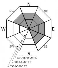
Slabs of drifted new snow will pose a hazard on steep slopes where they are more than about 8 inches thick. You'll find these in the tops of chutes, downwind of low points in ridges, and on the sides of gullies. They may be covering harder slabs that formed in the past few days. These older hard slabs are up to a foot thick and widespread at both mid and upper elevations. They haven't proven to be very reactive to a person's weight for the most part, though today's loading may make them more unstable. Steer clear of steep slopes with fresh drifts or hollow-feeling hard snow. Shooting cracks are a good sign you've found these conditions.
-
Type ?
-
Aspect/Elevation ?
-
Likelihood ?CertainVery LikelyLikelyPossible
 Unlikely
 -
Size ?HistoricVery LargeLargeSmall

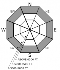
On very steep slopes - those near 40 degrees - where the surface snow is wet, you can trigger small wet snow avalanches that can be dangerous above gullies, creekbeds, tree wells, trees, or rock bands. The likelihood of these slides will increase through the day, as refrozen snow surfaces soften, or during periods of rain. Fresh pinwheels of wet snow and fan-shaped releases of rollerballs are good signs that the hazard of wet snow slides is increasing. These slides are not a hazard on slopes where the snow surface is dry or a supportable crust.
-
Type ?
-
Aspect/Elevation ?
-
Likelihood ?CertainVery LikelyLikelyPossible
 Unlikely
 -
Size ?HistoricVery LargeLargeSmall

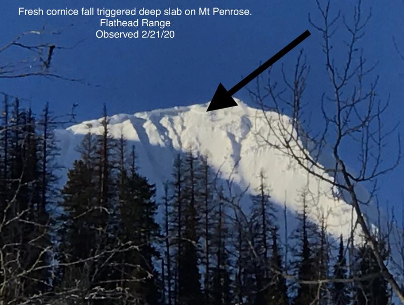
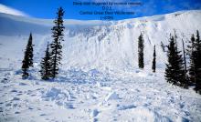
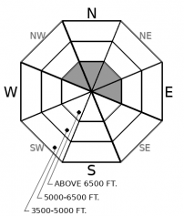
Cornice fall triggered a large avalanche on a northeast-facing slope near Mt. Penrose Thursday or Friday. The slide is a good reminder of the lingering danger of large avalanches breaking on weak snow near the ground in high alpine bowls and faces in the Flathead Range and Glacier Park on northerly and easterly aspects. While these slides are unlikely, it's good policy to limit your time under steep northerly and easterly start zones near ridges, particularly those with large cornices and active loading. Plumes of snow at ridges are a good sign of the latter.
Today's a transition day, with new hazards arriving through one door while others exit a second. First, the building hazards.
Most of the region will see at least a few inches of new snow today, with the most intense snowfall this afternoon. Moderate to strong southwesterly winds will accompany the snow. While snow levels may rise above valley floors this afternoon, mid and upper elevations should see all snow. Accumulations are a little uncertain, with some models favoring the Whitefish Range and others the Swan.
Expect new wind slabs to form through the day, mostly in upper elevation start zones on the lee sides of ridges. These should be mostly soft, and they'll be forming on top of hard slabs that formed over the past few days. They may break at that interface, or involve both generations of wind slabs. While most of these older slabs have stubbornly remained in place, one party in the southern Whitefish Range was able to trigger a small, fresh hard slab yesterday that failed on surface hoar, and another party reported a falling cornice that triggered a pocket of wind slab.
In terrain not affected by recent winds, the new snow will be falling on faceted snow, melt-freeze crusts, and pockets of well-developed surface hoar. I don't expect enough new snow to form stiff and potentially dangerous slabs in most terrain. But there are caveats, given the uncertainty in the models. These would be slopes with more than about 8 inches of new snow, particularly if it's accumulating at more than about an inch an hour. Or if it's falling on buried surface hoar, which should be easy to identify by digging down with your hands to the old snow surface.
The wet snow avalanche hazard of the past few days is diminishing, thanks to at least a few hours of below freezing temperatures last night. However, greenhousing late yesterday left low elevation snow on all aspects wet. With rising temperatures and a chance of rain at low elevations, small wet loose avalanches are possible on steep slopes where the snow surface isn't frozen.
A warm, wet and windy southwesterly flow will bring gusty winds and new snow to the region today, in advance of a cold trough. It's not clear which, if any, range that's favored by the models, though the Swan Range tends to wring lots of snow out of systems like this. More snow is likely tonight.
This forecast applies only to backcountry areas outside established ski area boundaries. The forecast describes general avalanche conditions and local variations always occur. This forecast expires at midnight on the posted day unless otherwise noted. The information in this forecast is provided by the USDA Forest Service who is solely responsible for its content.


