| Wednesday | Wednesday Night | Thursday | |
|---|---|---|---|
| Cloud Cover: | Partly Cloudy | Mostly Clear | Mostly Clear |
| Temperatures: | 19 to 25 deg. F. | 4 to 10 deg. F. | 24 to 30 deg. F. |
| Wind Direction: | Southwest | South | South |
| Wind Speed: | 0 to 10 | 0 to 10 | 0 to 10 |
| Snowfall: | 0" in. | 0" in. | 0" in. |
| Snow Line: | 500' | 1000' | 1000' |
Whitefish Range
Swan Range
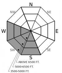
How to read the forecast

2. Moderate
?
Above 6500 ft.
2. Moderate
?
5000-6500 ft.
2. Moderate
?
3500-5000 ft.
- 1. Low
- 2. Moderate
- 3. Considerable
- 4. High
- 5. Extreme
-
Type ?
-
Aspect/Elevation ?

-
Likelihood ?CertainVery LikelyLikelyPossible
 Unlikely
 -
Size ?HistoricVery LargeLargeSmall

Solar radiation and warming temperatures may destabilize the snow surface on steep, sun-baked slopes by this afternoon. As the snow surface moistens, watch for small point releases near rock bands or on very steep slopes. Although sluffs today should mostly be small, they could entrain enough snow to be dangerous in long-running gullies or if they push you into terrain traps such as trees or over cliffs. This instability is easy to recognize and avoid: If you see rollerballs, pinwheels, or natural sluffs, move towards cold, dry snow in the shade or onto lower angle terrain.
The threat of natural loose wet avalanches and cornice falls will accompany the warming trend and sunshine this week. The timing and extent of avalanche activity is uncertain. Observers yesterday reported a few rollerballs and minor point releases as the sun broke through the clouds yesterday afternoon. Today we will see less cloud cover and temperatures will climb a few degrees higher. I expect the relatively cool temperatures will help moderate surface warming and keep most loose wet avalanches relatively small and isolated, with the danger teetering between LOW and MODERATE. Slides could be larger in steep, long-running gullies, the kind that are most common in the Flathead Range and Glacier Park. Thursday’s warmer temperatures and stronger solar radiation will likely bring larger or more widespread activity and increasing concerns for cornice falls. Fortunately, these are easy problems to identify and avoid. Loose wet avalanches give clear warning signs before they occur: rollerballs and pinwheels or adjacent natural activity. Cold, shady aspects will be hosting high quality powder and safer riding, provided you can stay out of the line of fire of a random cornice fall. Cornices don’t give clear warning signs before trundling down slopes, but their presence above you is easy to identify.
In the Flathead Range and Glacier Park, we remain uneasy about the rare yet destructive potential for a cornice fall to trigger a deep slab avalanche. Deep slabs have been trending towards improvement since a cycle in early February, but poor structures remain in isolated areas. This rider yesterday turned away from a committing slope because of an unnerving snowpack structure. There are a lot of sagging “backcountry bombs” perched precariously over the type of terrain that has produced deep slab avalanches this winter, and warm sunny weather can weaken the roots of those sagging cornices.
Sun lovers rejoice! A high amplitude ridge spanning from the Yukon to the West Coast is moving towards Montana. Clearing skies and a warming trend are in store through Friday before the ridge flattens, ushering in precipitation for the weekend. This morning, mountain temperatures are mostly single digits rising towards upper 20’s this afternoon. Cloud cover and snow flurries are expected to stick around this morning, especially near the Continental Divide. Thursday will be warmer as the axis of the ridge moves overhead and draws a stronger southwesterly component.
This forecast applies only to backcountry areas outside established ski area boundaries. The forecast describes general avalanche conditions and local variations always occur. This forecast expires at midnight on the posted day unless otherwise noted. The information in this forecast is provided by the USDA Forest Service who is solely responsible for its content.


