| Thursday | Thursday Night | Friday | |
|---|---|---|---|
| Cloud Cover: | Mostly Cloudy | Mostly Cloudy | Mostly Cloudy |
| Temperatures: | 25 to 32 deg. F. | 16 to 21 deg. F. | 22 to 29 deg. F. |
| Wind Direction: | Southwest | Southwest | Southwest |
| Wind Speed: | 12G25 | 26G40 | 21G39 |
| Snowfall: | 0" in. | 3" to 5" in. | 1" in. |
| Snow Line: | 2000' | 2500' | 1000' |
Whitefish Range
How to read the forecast
Generally stable avalanche conditions will continue today. Afternoon sun and warm temperatures may produce small wet loose avalanches. Look for point releases out of rocky areas or rollerballs as signs to seek out shaded aspects. Shallow pockets of wind drifted snow linger. These will be easy to identify by seeing pillowy looking surfaces below recent cornice formations or on cross-loaded terrain features.

1. Low
?
Above 6500 ft.
1. Low
?
5000-6500 ft.
1. Low
?
3500-5000 ft.
- 1. Low
- 2. Moderate
- 3. Considerable
- 4. High
- 5. Extreme
-
Type ?
-
Aspect/Elevation ?

-
Likelihood ?CertainVery LikelyLikelyPossible
 Unlikely
 -
Size ?HistoricVery LargeLargeSmall

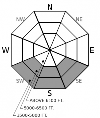
If weather forecast verifies, a break in clouds and warm temperatures will moisten the surface snow and cause wet loose avalanches. Even small avalanches can be consequential if they push you into a terrain trap. Rollerballs or pinwheels are signs that conditions are ripe for wet loose avalanches. Plan your day and exit accordingly to be out from underneath south and southwest facing avalanche paths in the afternoon hours.
-
Type ?
-
Aspect/Elevation ?

-
Likelihood ?CertainVery LikelyLikelyPossible
 Unlikely
 -
Size ?HistoricVery LargeLargeSmall

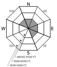
Observers and forecasters continue to find wind slabs predominately on slopes leeward to southwesterly winds. Expect to find isolated wind slabs that will be consequential if they push you into a terrain trap. Steer around dense, pillowy slabs of drifted snow by sticking to terrain that was sheltered by the wind. Northerly winds deposited isolated pockets of wind slabs onto south facing aspects. These slabs should be relatively harmless but can catch you off guard due to being in an atypical location.
Wind slabs have been the primary concern for the past two days. Moderate to strong southwesterly winds rapidly transported new snow on Tuesday. At that time, forecasters and observers found reactive wind slabs 4 to 12 inches thick in the Flathead Range, Swan Range, and Glacier National Park. On Wednesday (yesterday), observers found stubborn wind slabs on northeasterly facing slopes, and small, reactive wind slabs on southerly facing slopes from a brief period of northerly winds. Mild weather will bring a continuation of this trend today.
Today, expect wind slabs to be of most concern at upper elevations below ridgelines and on cross-loaded terrain features in the Flathead Range, Swan Range, and Glacier National Park. You can still find reactive wind slabs in isolated spots at mid-elevations, such as the lee sides of gullies and below ridgelines. Identify and avoid this problem by looking for bulbous pillows of snow, or feeling for denser snow underfoot. Fresh snow covering these slabs may make identifying them by sight alone more challenging. Figure they're lurking in areas prone to collect drifting snow and approach these spots cautiously.
Additionally, if the weather forecast verifies, we can expect to see point releases on south-facing aspects. Weather models are showing a break in clouds during afternoon hours when temperatures are at their warmest. If you feel the warm sun hit your back on your ascent, plan to seek out shaded slopes for safer and better riding conditions. Plan your day accordingly if your exit requires you to cross underneath south-facing avalanche paths during afternoon hours.
A weak ridge will lend us a brief period of mild weather today. Above freezing temperatures will hover around 5000 feet. Expect partly cloudy skies with winds light gusting to moderate. An approaching cold front will bring increasing winds and widespread snow tonight and into tomorrow.
This forecast applies only to backcountry areas outside established ski area boundaries. The forecast describes general avalanche conditions and local variations always occur. This forecast expires at midnight on the posted day unless otherwise noted. The information in this forecast is provided by the USDA Forest Service who is solely responsible for its content.


