| Tuesday | Tuesday Night | Wednesday | |
|---|---|---|---|
| Cloud Cover: | Mostly Cloudy | Mostly Cloudy | Partly Cloudy |
| Temperatures: | 23 to 29 deg. F. | 9 to 14 deg. F. | 21 to 27 deg. F. |
| Wind Direction: | Southwest | Northwest | Northeast |
| Wind Speed: | 15 to 25 G45 | 7 to 17 G30 | 5 to 15 G25 |
| Snowfall: | 1" to 3" in. | 0" in. | 0" in. |
| Snow Line: | 2000' | 1500' | 500' |
Flathead Range and Glacier National Park
How to read the forecast
Winds are increasing and conditions are changing. Watch for new and recent snow to drift into shallow slabs in wind-exposed locations. These could be dangerous around terrain traps, or if they entrain or step down into older snow. Wind sheltered terrain is serving up the safest and best quality riding right now. Mind your sluffs though.

2. Moderate
?
Above 6500 ft.
2. Moderate
?
5000-6500 ft.
1. Low
?
3500-5000 ft.
- 1. Low
- 2. Moderate
- 3. Considerable
- 4. High
- 5. Extreme
-
Type ?
-
Aspect/Elevation ?
-
Likelihood ?CertainVery LikelyLikelyPossible
 Unlikely
 -
Size ?HistoricVery LargeLargeSmall

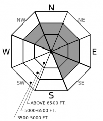
Southwest winds increased overnight and will continue to transport snow today. Recent and falling snow will drift into sensitive slabs in leeward and cross-loaded terrain. Most of these slabs will be shallow and small, but in sustained steep terrain, they can entrain dangerous amounts of soft snow that has accumulated earlier in the week. Blowing snow, fresh drifts, and cracking underfoot are signs to steer towards windward or wind-sheltered terrain.
-
Type ?
-
Aspect/Elevation ?
-
Likelihood ?CertainVery LikelyLikelyPossible
 Unlikely
 -
Size ?HistoricVery LargeLargeSmall

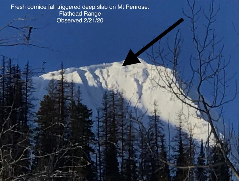
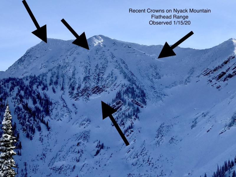
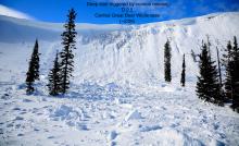
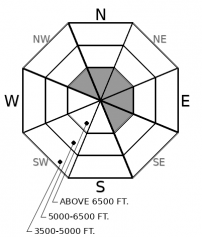
Several deep slabs have run naturally in the past few weeks (example A, example B), following an onslaught of deep slab activity in mid-January. These slabs failed on early-season weak layers near the ground, up to 20 feet thick, and ran full track - clearly unsurvivable events. Although deep slab failures are challenging to predict, they have been reliably failing in the same type of terrain all year: high alpine faces and bowls in the Flathead Range and Park that are oriented towards leeward and colder aspects. Deep slabs may require a large trigger, such as a cornice fall, to initiate, although we remain uneasy about human triggers from thin or shallow parts of the slope where rock bands or variable snow depths cause weak layers to be closer to the snow surface. Give steep alpine terrain like this a healthy dose of caution, especially below cornices. Choose routes that reduce your exposure to the runouts of the high start zones.
Yesterday, observers around the forecast area reported good stability apart from sluffing in very steep terrain, the result of 2” to 5” of fluffy new snow on Sunday night. Our concerns for slab avalanches to fail on the faceted crusts buried 1 to 2 feet deep have been waning as the snowpack continues to adjust to Saturday’s storm. Don’t get anchored to yesterday’s observations; conditions are changing today.
Although winds were light yesterday, they increased significantly overnight. For example, our Mt. Aeneas wind station was averaging about 10 mph yesterday, whereas winds are now cranking at 30 to 40 mph and gusting to 50. The fluffy, sluffy snow on the surface yesterday is readily available for transport, along with a few inches of new snow expected today. We are anticipating shallow instabilities to develop within the newly drifted snow – a straightforward problem to manage. However, we have some uncertainty about additional wind loading re-activating the buried faceted crusts that were quite active over the weekend. If a slide steps down to one of the early February crusts, it could be 1 to 3 feet thick. The simplest way to manage both fresh wind slabs and the uncertainty for older slabs is to ride in wind-protected terrain. In that type of terrain, you’ll have to manage for shallow sluffs while enjoying softer, higher quality snow. Skiers and riders have reported sluffing (or point release avalanches) all week on slopes steeper than about 38 degrees. Use sluff management techniques and slope cuts to manage the problem around terrain traps, or simply lower your slope angles if you don’t want to deal with sluffing.
A disturbance embedded in northwest flow is bringing gusty winds and light snowfall to the region. Snowfall will favor the southern boundary of our forecast area. The strongest winds are also pointed at the Swan, Flathead, and Park. This morning we are seeing average wind speeds varying from the teens in JFS Canyon, 25 mph at Hornet, and 40 mph on Mt. Aeneas, with gusts to 50. Winds will start to die down this afternoon.
This forecast applies only to backcountry areas outside established ski area boundaries. The forecast describes general avalanche conditions and local variations always occur. This forecast expires at midnight on the posted day unless otherwise noted. The information in this forecast is provided by the USDA Forest Service who is solely responsible for its content.


