| Wednesday | Wednesday Night | Thursday | |
|---|---|---|---|
| Cloud Cover: | Mostly Cloudy | Mostly Cloudy | Mostly Cloudy |
| Temperatures: | 21 to 24 deg. F. | 17 to 20 deg. F. | 26 to 31 deg. F. |
| Wind Direction: | Southwest | Southwest | Southwest |
| Wind Speed: | 17G29 | 17G33 | 14G25 |
| Snowfall: | 4" to 6" in. | 4" to 7" in. | 6" to 7" in. |
| Snow Line: | 1000' | 2500' | 2000' |
Swan Range
How to read the forecast
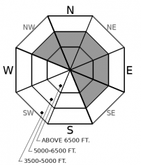
New snow and wind will increase the avalanche danger today by forming slabs of wind-drifted snow at mid and upper elevations. If you find 8 inches of new snow stack up, triggered slabs can be large enough to bury or injure you. Watch for blowing snow and pillowy-looking snow surfaces; these are cues to seek wind-sheltered terrain.

2. Moderate
?
Above 6500 ft.
2. Moderate
?
5000-6500 ft.
1. Low
?
3500-5000 ft.
- 1. Low
- 2. Moderate
- 3. Considerable
- 4. High
- 5. Extreme
-
Type ?
-
Aspect/Elevation ?

-
Likelihood ?CertainVery LikelyLikelyPossible
 Unlikely
 -
Size ?HistoricVery LargeLargeSmall

Expect new and drifting snow to build reactive slabs 6 to 12 inches deep on leeward aspects. Overnight, the Swan Range picked up 1 to 3 inches of fresh snow, and today the range could see an additional 4 to 6 inches. Sustained moderate winds out of the southwest will drift the snow below ridgelines and on cross-loaded gullies further downslope. Drifting snow, pillowy surfaces and cracking in the surface snow are your cues to seek wind-sheltered terrain. In areas with larger fetches and in more extreme terrain, slabs will be large enough to bury and injure a rider.
Out with the sunshine and in with the new. Overnight, most stations are showing 2 to 6 inches of fresh snow with moderate wind speeds. Today, unfortunately, it appears that the bulk of the moisture will remain south. Areas in the southern end of the forecast area, like the Swan Range, will be favored with 4 to 6 inches of snow today. Winds will continue to blow at moderate speeds and thus be prime for transporting snow. A key component moving forward will be the weak layer that new snow is falling on. I will let the video below do the talking for that topic.
In the Flathead Range and Glacier National Park, expect two flavors of wind slabs; soft, reactive wind slabs from today and yesterday, as well as stiff, stubborn wind slabs formed this weekend. New wind slabs in Flathead and Glacier will be sitting on faceting snow above the most recent crust, or older wind slabs. The older slabs produce deeper, more dangerous avalanches. New snow in the Whitefish Range and the Swan Range will be sitting on an inch of low-density snow above a faceted crust. This facets and crust combo will increase the potential to for freshly-formed slabs to propagate widely and run surprisingly far. Steer away from signs of drifting snow to reduce your risk. Areas that have not been touched by the wind will remain cohesionless, resulting in loose dry avalanches.
Deep Slab avalanches are a continuing concern for us. Though you are unlikely to trigger one, the consequences of doing one would be severe. I am continuing to avoid upper elevation, rocky terrain that faces north through east in the Flathead Range and Glacier National Park. A snow pit dug by BNSF railway forecasters shows the structure that is representative of slopes where these monsters have been started - a large stiff slab over weak, faceted crusts near the ground. I am going to give this problem more time before I jump into the kind of terrain that is hosting these foul players near the ground.
Today, expect lingering snow showers and moderate wind speeds. Warm frontal passage will bring temperatures nearing 30 degrees F and snow levels up to 4000 feet.
This forecast applies only to backcountry areas outside established ski area boundaries. The forecast describes general avalanche conditions and local variations always occur. This forecast expires at midnight on the posted day unless otherwise noted. The information in this forecast is provided by the USDA Forest Service who is solely responsible for its content.


