| Monday | Monday Night | Tuesday | |
|---|---|---|---|
| Cloud Cover: | Mostly Clear | Partly Cloudy | Partly Cloudy |
| Temperatures: | 15 to 21 deg. F. | 2 to 5 deg. F. | 15 to 20 deg. F. |
| Wind Direction: | North | West | Southwest |
| Wind Speed: | 0 to 10 | 5 to 10, G20 | 10 to 20, G30 |
| Snowfall: | 0" in. | 0" in. | 0" in. |
| Snow Line: | 0' | 0' | 0' |
Flathead Range and Glacier National Park
How to read the forecast
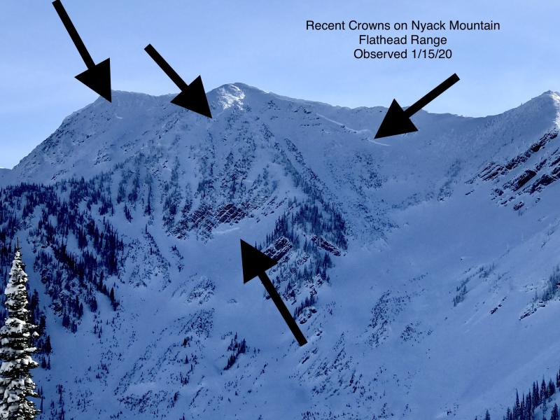
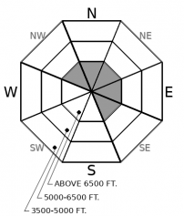
Below Saturday's rain line, a solid melt-freeze crust has locked the snowpack in place. Today is a beautiful day to climb high into the mountains, where conditions are softer and views are spectacular. Choose your terrain carefully as you ascend above the crust: stay on slopes with deep and uniform snowpacks. Several very destructive deep slabs ran only two days ago: though buried persistent weak layers are difficult to trigger, they are also slow to adjust and carry huge consequences.

2. Moderate
?
Above 6500 ft.
1. Low
?
5000-6500 ft.
1. Low
?
3500-5000 ft.
- 1. Low
- 2. Moderate
- 3. Considerable
- 4. High
- 5. Extreme
-
Type ?
-
Aspect/Elevation ?
-
Likelihood ?CertainVery LikelyLikelyPossible
 Unlikely
 -
Size ?HistoricVery LargeLargeSmall

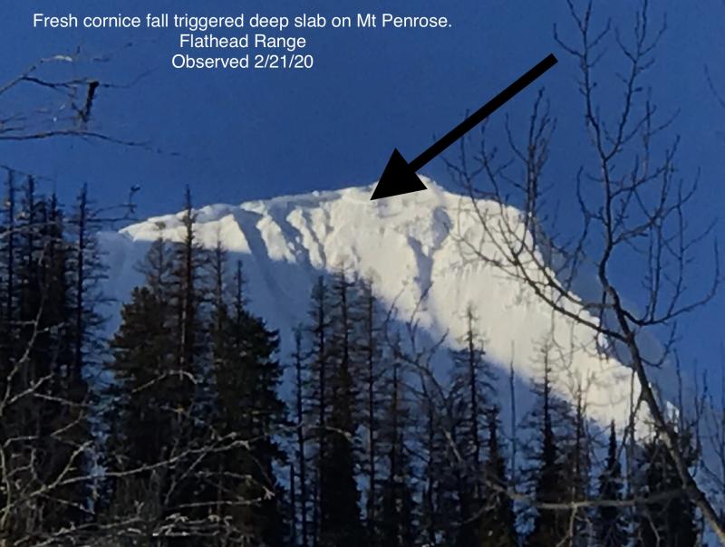
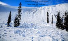
Saturday's warm, wet, and windy weather spurred numerous deep slab avalanches that broke up to 20 feet deep on weak layers near the ground in the Flathead Range. Weather conditions have changed drastically since then, and the odds of a natural or triggered slide are quite low today. The consequences, however, are deadly. While deep slab failures are often unpredictable, they have been reliably failing in a predictable terrain pattern all month: the terrain that held continuous and well developed weak layers during our fall dry spells. Be cautious of steep alpine bowls and faces at high elevations that face the northerly or easterly quadrants of the compass. Although it may require a large trigger such as a cornice fall, deep slabs can also be triggered from shallow or thin parts of the slab. Because those spots are hard to recognize from the surface, give terrain with rock bands or variable snow depths a wide berth to play it safe.
-
Type ?
-
Aspect/Elevation ?

-
Likelihood ?CertainVery LikelyLikelyPossible
 Unlikely
 -
Size ?HistoricVery LargeLargeSmall

At upper elevations, up to 6" or 7" of soft snow sits above firm surfaces or crusts. In isolated areas, this snow has drifted into soft and small slabs. Observers noted some minor cracking in these drifts yesterday, the type of instability that is only a concern in very consequential terrain. Pay attention to how thick and reactive these slabs are if you are seeking out extreme terrain. You can easily avoid the potential for any lingering instabilities by riding where the snow hasn't been stiffened by the wind.
Rain-on-snow on Friday night and Saturday morning blessed the snow surface with a stout, bombproof melt-freeze crust. In terrain where you feel this crust below your feet or machine, the snowpack is generally stable, and you are very unlikely to trigger an avalanche that breaks deeper than whatever new snow is sitting above the crust. In the Swan and the Whitefish Range, that new snow is only a dusting. In the Flathead Range and Glacier Park, there is up to 6" or 7" of soft snow with some minor amounts of wind effect. Our forecasters spread out into the Park and the Flathead Range yesterday hunting for wind slab concerns and found that drifts in the recent snow were small and produced only minor cracking (See observation).
And now the caveat to a stable snowpack: the unwelcomed, unruly guest who is still on your couch this morning, long after the Super Bowl Party has ended. We have tallied at least three deep slabs that ran in the Flathead Range on Saturday - only two days ago - on Mt. Cameahwait and on Grant Peak. These were all unsurvivable, and to be honest, quite remarkable and fascinating slides that as forecasters, we rarely see. Because deep slab conditions like this are so rare, and direct feedback from them is equally rare, we operate under a lot of forecaster uncertainty. Weather conditions have drastically improved since Saturday, and the odds of triggering a deep slab are low. Does the stout crust on the surface help? Yes, where that crust is present, it may be downright impossible to impact a deep weak layer. However, the crust does not reach up to the summits of the Flathead or Glacier Park. Observers near Essex reported the crust up to at least 7,800', yet the crust stopped at 7,100' in our travels to investigate the crown on Mt. Grant. At elevations higher than the rain crust, it is still a winter snowpack, and I'm still cautious of suspect alpine terrain. That's because there is zero margin for error with hard slab avalanches that can break up to 20 feet deep. Deeply buried weak layers are slow to adjust to stress, and they are notorious for surprises. It's a great day to get up high in the alpine and enjoy the views. Choose your terrain carefully.
A note to our regular users. You may have noticed that we decreased the size of deep slabs down to just D3 (very large), in spite of the fact that we observed several D4s from this past cycle. The slabs have not gotten any smaller, but the amount of snow available to entrain in the tracks and runouts is much less, now that the snowpack at lower elevations is refreezing. The adjustment is intended to show that slides won't run quite as large or far as earlier in the week. But for human triggers, the adjustment is trivial: if you get caught in a D3 or D4 hard slab, the consequences will be the same. The size will increase again once we get more soft or wet snow in the tracks and runouts.
Another cold clear day is in store as a Pacific trough sags well south of us. Mountain temperatures this morning are in the single digits and winds are calm. Winds start to increase tomorrow ahead of the next weather system on Tuesday night.
This forecast applies only to backcountry areas outside established ski area boundaries. The forecast describes general avalanche conditions and local variations always occur. This forecast expires at midnight on the posted day unless otherwise noted. The information in this forecast is provided by the USDA Forest Service who is solely responsible for its content.


