| Sunday | Sunday Night | Monday | |
|---|---|---|---|
| Cloud Cover: | Decreasing clouds | Mostly Clear | Mostly Clear |
| Temperatures: | 18 to 24 deg. F. | 2 to 5 deg. F. | 15 to 21 deg. F. |
| Wind Direction: | West | West | North |
| Wind Speed: | 5 to 10, G20 | 0 to 10 | 5 to 15, G20 |
| Snowfall: | 0" in. | 0" in. | 0" in. |
| Snow Line: | 0' | 0' | 0' |
Whitefish Range
Swan Range
How to read the forecast
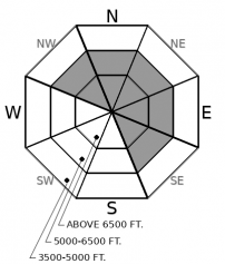
The snowpack has quickly stabilized due to cold air refreezing yesterday's wet snow surface into a stout crust. The isolated exception: small drifts of snow that formed above the crust. Be mindful of terrain traps if you find yourself carving a turn somewhere deeper than dust on crust.

1. Low
?
Above 6500 ft.
1. Low
?
5000-6500 ft.
1. Low
?
3500-5000 ft.
- 1. Low
- 2. Moderate
- 3. Considerable
- 4. High
- 5. Extreme
-
Type ?
-
Aspect/Elevation ?

-
Likelihood ?CertainVery LikelyLikelyPossible
 Unlikely
 -
Size ?HistoricVery LargeLargeSmall

After yesterday's snow surface refroze, about an inch of new snow fell on top of the crust, accompanied by extreme southwesterly winds. That's not much snow for winds to work with, but in isolated areas, you may find small pockets of wind drifted snow that could get you into trouble in extreme terrain or above cliffs. Reading and listening to the snow surface is the easiest way to manage this problem. If you see or feel a crust, you're good to go. It will glisten and sound scratchy. If you cross into a deeper pocket of chalky, dry snow, you've found a wind slab. It will look dull white, feel softer, and sound less scratchy. That might be the best turn of your day, but be cautious if you're in terrain where you can't afford to get knocked off your feet or machine.
The weather has taken us for a wild ride in the past 36 hours. Freezing levels rose to over 7,000' on Friday night, accompanied by up to an inch of rain (or dense snow in the higher peaks of the Flathead and Park). Southerly and southwesterly winds gusted to over 70 mph. The avalanche danger spiked on Friday night into Saturday morning. Limited observations so far confirm that a number of large wind slabs ran in the Flathead Range, and at least one deep slab pulled out to the ground of Mt. Cameahwait. In the Whitefish and Swan Ranges, the high freezing line submerged the ranges in rain, limiting wind transport but causing wet avalanche problems. On Saturday afternoon, a cold front passed across the region, refreezing wet surfaces and effectively ending any wet avalanche concerns. While the front brought only a dusting of new snow to the Whitefish and Swan Ranges, it favored the Continental Divide and Rocky Mountain Front with about 6" of new snow. Winds are still gusting into the 30's this morning, but should ease off by mid morning.
In the Whitefish and Swan Range, the snowpack has quickly stabilized. Riding conditions will be crusty, with only a dusting of new snow on the surface. That dusting of snow was blowing around all night, and might have collected into some small drifts. Those drifts will be small, harmless in size, and easy to spot and avoid. They may not have formed in classic wind-loaded locations due to extreme wind speeds. Rather, they might have formed all the way in Calgary, or random pockets further downslope.
In the Flathead Range and Glacier Park, the danger is also quickly subsiding, but there are larger and more hazardous problems to manage today. Several generations of wind slabs have formed since Thursday. The oldest will be only in the highest terrain, above Friday night's freezing line. Although these should be healing rather quickly now, they will also be the thickest and most dangerous. The 6" of new snow that fell after yesterday's cold front will have drifted into wind slabs that are more common, but smaller. Avoid leeward and crossloaded drifts to manage these problems. Friday's and Saturday's warm, wet, windy, and dramatic weather was a good test on the deep weak layers that we have been advertising in our forecasts all month. They failed yet again. The likelihood of a natural or human triggered deep slab has decreased now that the weather system has passed. With unsurvivable deep slab activity as recently as yesterday, it is best to exercise patience in suspect alpine terrain today.
Cold, calm, and sunny weather is in store for the next two days. Skies will clear today from north to south. Winds are gusting into the 30's this morning at select alpine locations, but should ease through the morning hours. After yesterday's highs reached nearly 40 degrees in the mountains, temperatures have made a welcomed return to winter. Mountain temperatures are currently in the teens and low 20's.
This forecast applies only to backcountry areas outside established ski area boundaries. The forecast describes general avalanche conditions and local variations always occur. This forecast expires at midnight on the posted day unless otherwise noted. The information in this forecast is provided by the USDA Forest Service who is solely responsible for its content.


