| Friday | Friday Night | Saturday | |
|---|---|---|---|
| Cloud Cover: | Mostly Cloudy | Mostly Cloudy | Mostly Cloudy |
| Temperatures: | 34 to 37 deg. F. | 31 to 34 deg. F. | 37 to 40 deg. F. |
| Wind Direction: | Southwest | Southwest | Southwest |
| Wind Speed: | 20 to 25, gusting to 45 | 25 to 35, gusting to 55 | 25 to 35, gusting to 55 |
| Snowfall: | 3" to 4" in. | 0" to 2" in. | 3" to 5" in. |
| Snow Line: | 6500' | 6500' | 5000' |
Swan Range
How to read the forecast
Dangerous avalanche conditions will develop as a wet and windy storm rakes the Swan Range today. Choose simple terrain with low slope angles. Avoid steep slopes where snow is blowing into fresh drifts and where rain is wetting the surface snow.

3. Considerable
?
Above 6500 ft.
3. Considerable
?
5000-6500 ft.
2. Moderate
?
3500-5000 ft.
- 1. Low
- 2. Moderate
- 3. Considerable
- 4. High
- 5. Extreme
-
Type ?
-
Aspect/Elevation ?

-
Likelihood ?CertainVery LikelyLikelyPossible
 Unlikely
 -
Size ?HistoricVery LargeLargeSmall

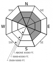
Moderate to strong southwest winds increase into tomorrow. Fresh drifts will be most widespread where more than a few inches of new snow accumulates and winds mix down to mid-elevations. The northern Whitefish, Flathead, and Swan ranges should receive the most snow. The Lake McDonald area and Swan Range should be the windiest. Expect two types of wind slab today – older slabs that are hard and stubborn, and fresh slabs that are more reactive. Avoid exposed terrain above treeline, just below ridges and cornices. Cross loaded features, like gullies, may also hold older drifted snow further down slope. Watch for blowing snow and rounded, textured, drifts. Shooting cracks are a sign of unstable wind slabs.
-
Type ?
-
Aspect/Elevation ?

-
Likelihood ?CertainVery LikelyLikelyPossible
 Unlikely
 -
Size ?HistoricVery LargeLargeSmall

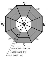
Rising freezing levels and rain on snow can be expected throughout today. Saturated new snow can sluff on very steep slopes. The problem will be most pronounced where snow gets wet for the first time. Expect wet avalanches at middle elevations today, and be wary of overhead hazards if freezing levels reach the upper elevations by early evening. Watch for rollerballs or small sluffs as signs of instability.
Stop me if you’ve heard this refrain before…Strong winds. Rising freezing levels. Rain and snow. These factors keep coming back like the greatest hits on a classic rock station, though they're less catchy.
Early in the week, southwest winds redistributed snow onto leeward aspects. A round of natural storm slabs ran at middle and upper elevations. Cam found recent soft slabs to size 2 in the Middle Fork, and blase and I saw several natural avalanches broke across leeward start zones in the central Swan Range. Yesterday we found these older drifts had hardened and become stubborn. However, a rider in Cascadilla managed to trigger one of the leftovers. Fortunately the rider escaped unscathed. Today, snowfall will be limited to the upper elevations favoring the northern Whitefish and Swan ranges, and near the Flathead crest. Winds will be moderate to strong across the region. Expect new wind slabs to become sensitive where the most new snow is available for transport onto leeward slopes.
Warm temperatures and sun have heated the surface snow at low elevations. Observers reported wet snow, rollers, and sluffing through yesterday. Today will reprise the same theme. Freezing levels will rise higher and precipitation will turn to rain, with the rain snow line somewhere between 6000 and 6500 feet. Expect the wet snow avalanche problem to be most widespread where the surface was previously dry – on very steep middle elevation slopes. If freezing levels are higher than forecast and rain falls on new snow at upper elevations this afternoon, loose wet avalanches could become likely at upper elevations as well.
The hit parade of storms in recent weeks has limited the development of persistent weak layers in the upper snowpack. The stack of January crusts seem well bonded to the surrounding snow. The last avalanches that failed on these crusts were reported early in the week. The few exceptions have been propagating snowpack tests that have failed where graupel sits on top of the most recent ice layer. At the bottom of the snowpack, it’s a whole different tune. Weak layers that developed early in the season have released very large avalanches in the Flathead Range with almost every warm storm this season. A few have failed on a similar structure in the norther Whitefish Range. If the rain line climbs to upper elevations, or wind loading is intense, destructive avalanches will become possible in craggy alpine terrain.
Light to moderate snow will continue thoughout the day at upper elevations. By late morning, freezing levels should rise to middle elevations and may climb to 7,000' in the evening. Preciptation below there will be a rain/snow mix. Winds will be strong to moderate and increase tonight into tomorrow with a tightening pressure gradient aloft.
This forecast applies only to backcountry areas outside established ski area boundaries. The forecast describes general avalanche conditions and local variations always occur. This forecast expires at midnight on the posted day unless otherwise noted. The information in this forecast is provided by the USDA Forest Service who is solely responsible for its content.


