| Friday | Friday Night | Saturday | |
|---|---|---|---|
| Cloud Cover: | Mostly Cloudy | Mostly Cloudy | Mostly Cloudy |
| Temperatures: | 31 to 37 deg. F. | 25 to 28 deg. F. | 28 to 34 deg. F. |
| Wind Direction: | Southwest | Southwest | Southwest |
| Wind Speed: | 17G32 | 24G37 | 19G32 |
| Snowfall: | 4" to 6" in. | 1" to 3" in. | 0 to 1" in. |
| Snow Line: | 5000' | 4000' | 3000' |
Whitefish Range
How to read the forecast
Fresh wind slabs near ridgetops will create dangerous avalanche conditions. Wet snow down low can sluff on steep slopes. Be conservative with your terrain choices with an eye for consequences and overhead hazards. Watch for rollerballs and natural sluffs on steep slopes. As you gain elevation, avoid areas of drifted snow below cornices on leeward slopes. They can crack and slide under your weight. Unpredictable deep slab avalanches pose an overhead hazard under alpine start zones.

3. Considerable
?
Above 6500 ft.
2. Moderate
?
5000-6500 ft.
2. Moderate
?
3500-5000 ft.
- 1. Low
- 2. Moderate
- 3. Considerable
- 4. High
- 5. Extreme
-
Type ?
-
Aspect/Elevation ?
-
Likelihood ?CertainVery LikelyLikelyPossible
 Unlikely
 -
Size ?HistoricVery LargeLargeSmall

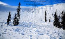
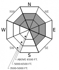
Moderate to strong southwest winds will continue through this evening. There has been plenty of soft snow available for them to redistribute in the Flathead and Whitefish Ranges. The Swan Range will receive the most new snow today, providing more ammo for fresh drifts. Fresh slabs will be easy to trigger, but larger, thicker slabs have been developing over slick crusts, and they may not bond well either. You’ll find bigger slabs in exposed terrain above treeline, just below ridges and cornices, like this recent large natural avalanche. Cross loaded features, like gullies, may also hold drifted snow further down slope. Watch for blowing snow and rounded, textured, drifts. Shooting cracks are a sign of unstable wind slabs.
-
Type ?
-
Aspect/Elevation ?
-
Likelihood ?CertainVery LikelyLikelyPossible
 Unlikely
 -
Size ?HistoricVery LargeLargeSmall

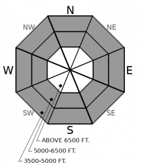
The freezing level has hovered in the middle elevation band since yesterday with no overnight freeze and some light rain. Saturated snow will easily sluff on the ice crust deposited early in the week; the size will depend on how much wet snow is above the crust and how large the terrain is. There is more wet snow to slide above about 5,000 feet in the Flathead and Swan Ranges. Watch for rollerballs or small sluffs on steep slopes to clue you into instabilities. Even small wet sluffs can be hard to escape and can have big consequences when combined with terrain traps. Watch for long-running sluffs coming down from overhead when traveling below steep gullies.
-
Type ?
-
Aspect/Elevation ?
-
Likelihood ?CertainVery LikelyLikelyPossible
 Unlikely
 -
Size ?HistoricVery LargeLargeSmall

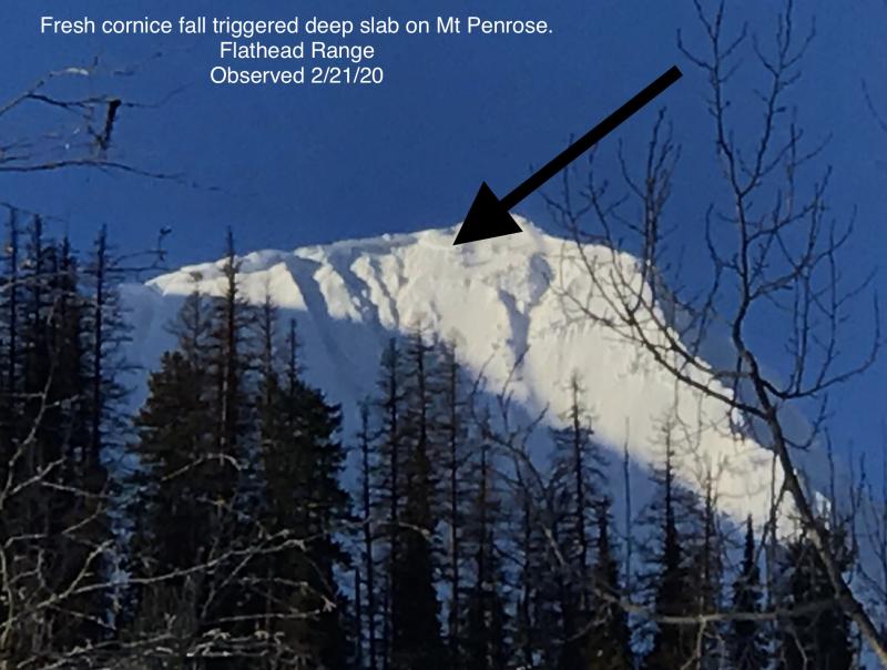
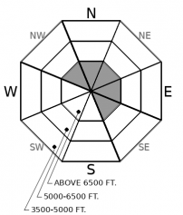
Deep slab avalanches are hard to predict and can be dangerously large. Shallow spots where the snowpack is thinner are likely trigger points deep slabs. You can find that kind of variable snow cover on rocky, leeward, alpine terrain. Convexities and unsupported slopes ending in rock bands are also suspicious. Small avalanches may be just the thing to suddenly overload deeply buried weak layers: reduce your exposure below suspect start zones. Most recently, cornice fall may have triggered a large persistent slab avalanche in the Flathead Range. The snowpack structure we’re worried about is most common in that zone and avalanches there can be bigger and more destructive, capable of breaking trees and producing huge debris piles in valley bottoms. Similar snowpack structure also exists in the northern Whitefish Range, and elsewhere.
Warm southwest flow is sticking with Montana today. It’s like your annoying cousin from Seattle who came to visit and won’t leave. He likes the heat turned up, he’s spilling water everywhere, he won’t stop talking, and he’s putting a dent in the couch.
Our lead forecaster, blase, saw rollerballs up to 6,700 in Skyland yesterday, and conditions have not improved. Weather stations below 6,000 feet haven’t recorded temperatures below freezing since yesterday, and freezing levels will hover around that elevation until dinner time tonight. So the snow at middle and lower elevations is already wet, and new precipitation today will likely be rain near and below treeline. Crusts from last weekend are buried under recent new snow and will be ideal sliding surfaces for wet snow avalanches. If the wet, warm weather breaks down the crusts, there’s also plenty of loose snow underneath that can become saturated and sluff.
Wind slabs were reactive to riders in the Flathead and Whitefish ranges on Wednesday. Yesterday, a D2 avalanche ran down on a northeast-facing slope from below a corniced ridge near 7200 feet. It likely involved recently-drifted snow; a natural cornice fall driven by warming may have been the trigger. Near ridgetops, southwest winds will continue to blow at speeds ideal for moving snow today. They’ll have more new snow to move in the Swan Range.
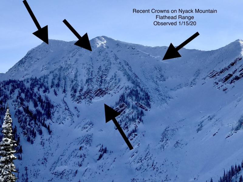
Crusts that formed around the holidays, and early-season, are buried 5 or more feet deep under a settling upper snowpack. These persistent weak layers failed most recently in the Flathead Range and northern Whitefish Range, but a similar snowpack structure exists elsewhere. Deep slab avalanches are very difficult to predict. What we do know is that warming and continued loading from wind and snow can make them more active.
We might get a break from your punk cousin tonight. Temperatures fall slightly and precipitation tapers of as a weak cold front passes and brief high pressure builds into the area on Saturday. Snow levels rise again, though, by Saturday night. Somebody buy this guy a ticket back to Seattle! He’s ruining all the pow!
Warm wet weather persists today until a cold from passes this afternoon allowing temperatures to dip. High pressure builds briefly on Saturday allowing a break in precipitation before another disturbance passes by into Sunday.
This forecast applies only to backcountry areas outside established ski area boundaries. The forecast describes general avalanche conditions and local variations always occur. This forecast expires at midnight on the posted day unless otherwise noted. The information in this forecast is provided by the USDA Forest Service who is solely responsible for its content.


