| Tuesday | Tuesday Night | Wednesday | |
|---|---|---|---|
| Cloud Cover: | Mostly Cloudy | Mostly Cloudy | Overcast |
| Temperatures: | 30 to 38 deg. F. | 20 to 25 deg. F. | 28 to 36 deg. F. |
| Wind Direction: | Southwest | Southwest | West |
| Wind Speed: | 7 to 12 gusting to 25 | 15 to 20 gusting to 30 | 20 to 25 gusting to 35 |
| Snowfall: | 0-2" in. | 4" to 7" in. | 2-4" in. |
| Snow Line: | 4500' | 3000' | 2000' |
Whitefish Range
Swan Range
Flathead Range and Glacier National Park
How to read the forecast
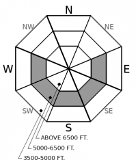
A wet snow avalanche hazard continues today, primarily on and below steep, sunny, slopes. Avoid riding in this terrain if you see snowballs running down slope or wet snow sticks to your boards, snowshoes, or machine. This danger will develop sooner and be more widespread if skies are sunnier than forecast. Stick to sheltered slopes that aren't below leeward, upper-elevation start zones to reduce your exposure to destructive avalanches that break on weak layers near the ground.

2. Moderate
?
Above 6500 ft.
2. Moderate
?
5000-6500 ft.
1. Low
?
3500-5000 ft.
- 1. Low
- 2. Moderate
- 3. Considerable
- 4. High
- 5. Extreme
-
Type ?
-
Aspect/Elevation ?

-
Likelihood ?CertainVery LikelyLikelyPossible
 Unlikely
 -
Size ?HistoricVery LargeLargeSmall

Triggered and natural wet snow avalanches remain a hazard today. The hazard will develop soonest and be most widespread on very steep, mid elevation slopes that face into the sun. It will be isolated at elevations above and below that because of cloud cover and inversions. Move on to colder, shadier slopes if you see balls of wet snow fanning downslope. Once these start entraining snow, the resulting sluffs can be tough to escape and can easily bury you or push you into or over a terrain trap. Manage your day so you can exit without having to travel under steep, sun-exposed slopes, particularly those that funnel debris into gullies.
-
Type ?
-
Aspect/Elevation ?

-
Likelihood ?CertainVery LikelyLikelyPossible
 Unlikely
 -
Size ?HistoricVery LargeLargeSmall

Avoid riding on or below steep, leeward slopes at upper elevations. The potential for triggered or natural avalanches lingers in the ongoing warm weather. These can break on weak layers near the base of the snowpack, producing very large and destructive slides like those that ran last week. Most recent reports of these avalanches are from the Flathead Range, where early season weak layers are well-developed and well-preserved. The danger exists in other ranges, though it appears to be confined to high, cold, alpine terrain.
Monday saw less warming of snow surfaces and less wet snow avalanche activity than anticipated, thanks to valley inversions and lingering or approaching cloud cover, depending on location. With brief or no overnight freeze at mid elevations, Loose Wet avalanches remain a hazard in that elevation band today. Valley inversions will limit warming at low elevations. Light southwest winds and clouds should keep a lid on radiation and temperatures at upper elevations.
More large and very large natural avalanches look to have run in the cycle early last week. These occurred in the Flathead Range on upper elevation, leeward slopes. Basically, the big, alpine terrain just below the crest of the range. Several of the slopes weren't well buttressed from below; others look to have the kind of rocky ground cover that promotes variable snow depths and multiple potential trigger points. These avalanches slid on weak layers near the ground - facets or facet/ crust combinations from November or possibly October. On similar slopes that haven't slid, the slabs above these weak interfaces are consolidating in the current warm temperatures and undergoing other processes that increase the potential for more natural avalanches, despite the lack of loading. Bottom line: keep well out from under terrain like this today.
We had several reports of surface hoar or small facets already growing on top of the most recent holiday rain crust - the MLK freezing rain crust. That's not a problem now, though it may be a concern if those crystals are buried intact. The crust is not omnipresent; so far reports indicate it's thickest on the west side of the Whitefish Range, and thinner in areas to the east and southeast. It doesn't exist in some valley bottoms yet is present higher in the same drainages. It would be very helpful to get a more precise idea of where it's located, since snow should start burying it tonight and through the week. Let us know where you're finding it and whether it's topped by facets or surface hoar.
Warm air continues to flow into the region from the southwest, though a trough swinging towards the area will bring cooler, wetter air late today. Valley inversions will be slow to break today. Expect another day of mild temperatures at mid and upper elevations, with light to moderate winds. The chance of showers increases this afternoon, though precipation type - snow, rain, freezing rain - will depend on timing and elevation. The rest of the week looks wetter.
This forecast applies only to backcountry areas outside established ski area boundaries. The forecast describes general avalanche conditions and local variations always occur. This forecast expires at midnight on the posted day unless otherwise noted. The information in this forecast is provided by the USDA Forest Service who is solely responsible for its content.


